

 Vorschau anzeigen
 Versenden
 Teilen
 Details anzeigen

 Herunterladen
 Ähnliche Objekte
 Röntgenaufnahme
 Diashow
 Stats
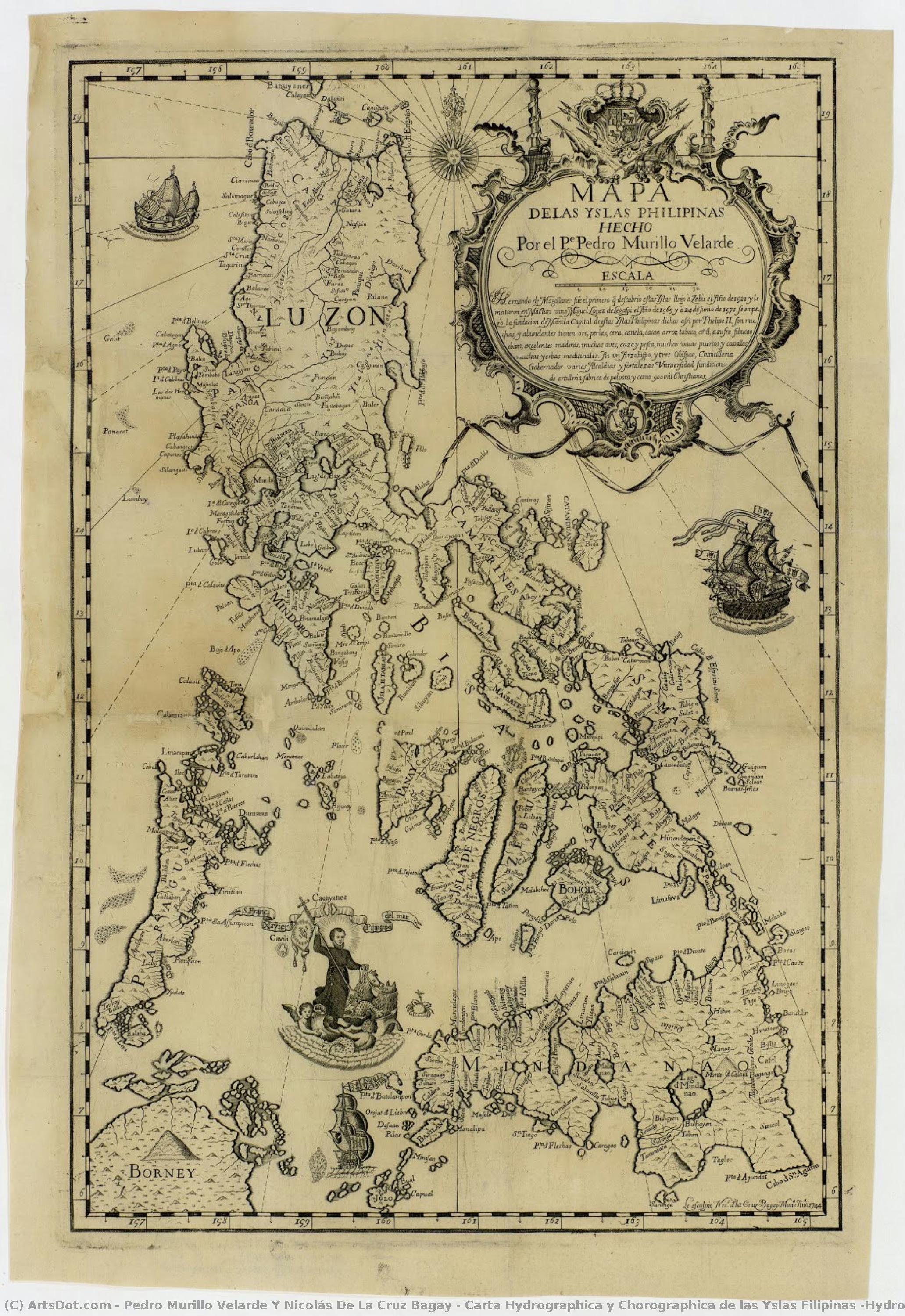
StatsCarta Hydrographica y Chorographica de las Yslas Filipinas (Hydrographic and Chorographic Map of the Philippines)


 Weiterlesen
Erwerben Sie ein hochauflösendes, optimiertes digitales Bild, das der Online-Vorschau weit überlegen ist.
Jede Datei wird von unseren hauseigenen Spezialisten mit modernsten Werkzeugen und fachmännischer manueller Retusche sorgfältig vorbereitet. Wir stellen sicher, dass jedes Bild eine außergewöhnliche Klarheit, präzise Farbgenauigkeit und feinste Details aufweist.
Die endgültige Datei wird innerhalb von 72 Stunden per E-Mail zugestellt und ist für den sofortigen Einsatz in professionellen, redaktionellen und Druckumgebungen optimiert. Es handelt sich um dieselbe Qualität, der führende Designstudios, Verlage und Galerien vertrauen.
Digitales Bild
Laden Sie eine hochauflösende Datei für die persönliche Präsentation, den Druck und kreative Projekte herunter. ( Switch to Print Handgemalte Reproduktion bestellen)
In jeder Bestellung digitaler Bilder enthalten
Professionelle digitale Bereitstellung, garantiert
Wenn Sie sich für ArtsDot.com entscheiden, erhalten Sie nicht nur ein Bild – Sie erhalten ein professionell aufbereitetes digitales Kunstwerk, das mit höchster Präzision erstellt und durch eine Zufriedenheitsgarantie abgesichert wird. Hier ist alles, was automatisch mit Ihrer Bestellung geliefert wird:

Schnelle E-Mail-Zustellung
Ihre hochauflösende digitale Bilddatei wird Ihnen innerhalb von 72 Stunden nach der Bestellung per E-Mail zugestellt – bereit zur sofortigen Verwendung.

KI-optimierte digitale Datei
Ihre Kunstwerke werden professionell mithilfe fortschrittlicher KI-Tools und manueller Bearbeitung optimiert, um maximale Detailtreue, Klarheit und Farbgenauigkeit zu gewährleisten.

Lebenslanger kostenloser Neudruckservice
Datei versehentlich gelöscht oder verloren? Keine Sorge – wir senden sie Ihnen jederzeit kostenlos erneut zu.

Keine Einfuhrgebühren – jemals
Genießen Sie Ihr Kunstwerk sofort ohne Zollgebühren, Einfuhrabgaben oder Versandkosten – digitale Downloads sind immer steuerfrei.

Garantierte Farbtreue
Wir garantieren, dass Ihr digitales Bild mithilfe professioneller Werkzeuge und Farbmanagement die Originalfarben so präzise wie möglich wiedergibt.

100-Tage-Zufriedenheitsgarantie
Wenn Sie mit Ihrem digitalen Bild nicht zufrieden sind, werden wir es überarbeiten oder 100% innerhalb von 100 Tagen erstatten – ohne Wenn und Aber.

100% Geld-zurück-Garantie
Nicht zufrieden? Erhalten Sie innerhalb von 100 Tagen nach Erhalt Ihrer digitalen Datei eine vollständige Rückerstattung – ohne Wenn und Aber.

Rabatte bei Großbestellungen
3 Bilder kaufen, 10% sparen – 5 Bilder kaufen, 15% sparen – Ab 10 Bildern 20% sparen. Ideal für kreative Projekte, Galerien und Agenturen.
Ähnliche Kunstwerke








Biografie des Künstlers
The Architect of the Archipelago: The Legacy of Pedro Murillo Velarde
In the golden age of Spanish maritime exploration, few names resonate with as much scientific and cultural weight as Pedro Murillo Velarde. A man whose life was defined by the intersection of faith, mathematics, and discovery, Velarde was far more than a mere cartographer; he was a visionary who sought to capture the very soul of the Philippine archipelago through the precision of science. Born in Madrid, Spain, his early years were steeped in the rigorous intellectual traditions of Jesuit education. At Loyola College Madrid, he honed his mastery over the celestial and the terrestrial, developing an exceptional aptitude for astronomy and geometric calculations. This profound scientific foundation would later serve as the compass for his most enduring contribution to human knowledge.
The trajectory of Velarde’s life shifted irrevocably in 1726 when he accepted a prestigious mission from the Jesuit Order to relocate to Manila. Tasked with establishing a new observatory in the Spanish East Indies, Velarde brought with him an unwavering dedication to empirical observation. His arrival in the Philippines marked the beginning of a transformative era where European scientific methodology met the rich, complex realities of the Pacific. This period of his life was not merely about mapping coastlines; it was about translating the vast, intricate geography of a burgeoning colonial frontier into a language that the rest of the world could comprehend.
A Symphony of Collaboration and Craft
The true brilliance of Velarde’s work lies in its profound collaborative nature, representing a rare and beautiful union between European scholarship and indigenous artistry. While Velarde provided the mathematical rigor and hydrographic data gathered from arduous Jesuit expeditions, he recognized that such a monumental undertaking required a master's touch in physical form. This led to his historic partnership with Nicolás de la Cruz Bagay, an artisan of extraordinary talent from Pangasinan. As an engraver of unparalleled skill, Bagay possessed the ability to translate complex topographical surveys onto copper plates with breathtaking clarity.
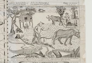
Together, they breathed life into the Carta Hydrographica y Chorographica de las Islas Filipinas. This was not a solitary achievement but a multidisciplinary masterpiece that also drew upon the artistic vision of Francisco Suárez. The resulting work was a tapestry of information, where scientific accuracy met aesthetic splendor. Through their combined efforts, the map became more than a navigational tool; it became a narrative medium. It depicted not only the intricate web of rivers, harbors, and islands but also the human element of the archipelago, illustrating various ethnic groups and the vibrant life that pulsed through the Spanish East Indies.
The Mother of All Philippine Maps
Completed in 1734, the Velarde Map has earned its venerable title as the "Mother of all Philippine Maps." Its historical significance cannot be overstated, as it stands as the first and most important scientific chart of the Philippines ever produced. The map’s intricate detail—capturing maritime routes from Manila to Spain and New Spain—provided a vital lifeline for colonial commerce and naval strategy. It was a document of immense political power, dedicated to the King of Spain, yet it possessed an ethnographic depth that captured the diverse identities of the islands, from the Sangley to the various indigenous tribes.
The map’s journey through history is as dramatic as its creation. During the British occupation of Manila in the late 18th century, the very copper plates used to print this masterpiece were seized and transported to England. This displacement led to a proliferation of copies across Europe, turning the Velarde Map into a celebrated antiquity that commanded high prices among collectors. Today, we look upon the work of Pedro Murillo Velarde not just as a relic of colonial cartography, but as a monumental achievement of human intellect—a moment in time when science and art converged to define the identity of an entire nation.
Kurzinfos
- Artistic Movement Or Style: Jesuit Cartography
- Artists Or Movements Influenced By This Artist: ['Cartography']
- Artists Who Influenced This Artist: ['Juan Ruiz Zafra']
- Date Of Birth: Living
- Full Name: Pedro Murillo Velarde y Nicolás de la Cruz Bagay
- Nationality: Spanish
- Notable Artworks: ['Carta Hydrographica y Chorographica de las Islas Filipinas']
- Place Of Birth: Spain