

 Ver en contexto
 Enviar
 Compartir
 Detalles

 Descargar
 Similares
 Radiografía
 Presentación de diapositivas
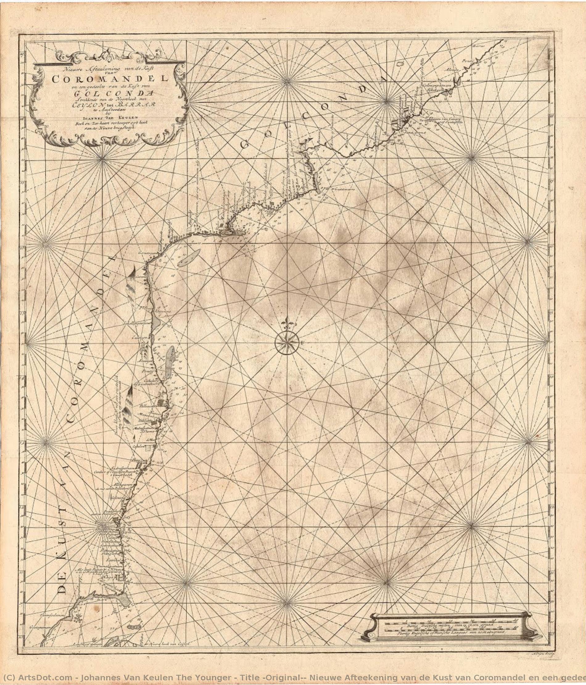
Title (Original): Nieuwe Afteekening van de Kust van Coromandel en een gedeelte van de Kust van Golgonda.
 Engraving
- Cartography
 Early Modern
 62.0 x 54.0 cm
 Archivos Kalakriti
 Ver más
Giclée / Impresión de arte
Impresiones giclée o en lienzo de calidad de museo con producción rápida y opciones de acabado flexibles. ( Comprar pintura hecha a mano Comprar imagen)




































Elija entre nuestros tamaños predefinidos que respetan las proporciones originales de la obra.

Puede introducir sus propias dimensiones para adaptarse a un marco o espacio específico. Si el tamaño seleccionado no coincide con las proporciones de la imagen original, recortaremos la obra de arte o extenderemos la imagen con un borde con efecto espejo o de color sólido. Se enviará una maqueta digital para su aprobación antes de que comience la producción.
Tenga en cuenta que la vista previa en pantalla no refleja el recorte o la extensión real. Solo la maqueta mostrará con precisión la composición final.
Aunque existen tamaños personalizados, recomendamos seleccionar una dimensión de la lista predefinida para preservar las proporciones originales.
Envío a todo el mundo () en 2 semanas en lugar de las 4/5 semanas estándar. (1 septiembre)

Envío exprés gratuito a todo el mundo

Lienzo de lino de alta calidad

Seguro de envío total

Garantía de reembolso de impuestos aduaneros

Garantía de fidelidad cromática exacta

Política de devolución de 60 días (solo por defectos)

Garantía de devolución del 100% del dinero

Descuento por cantidad
 La opción de vidrio solo está disponible en tamaños inferiores a 110 cm.

Title (Original): Nieuwe Afteekening van de Kust van Coromandel en een gedeelte van de Kust van Golgonda.
Giclée / Impresión de arte
Dimensiones de la reproducción
-


Precio total final
$ 62
A Cartographic Voyage Through Time
In the delicate, weathered lines of this exquisite sea chart, we find more than just a geographical record; we encounter a window into the Age of Discovery. This remarkable piece, titled Nieuwe Afteekening van de Kust van Coromandel en een gedeelte van de Kust van Golgonda, serves as a profound testament to the maritime ambitions of the Dutch East India Company (VOC). Created by the skilled hand of Johannes van Keulen the Younger, this map captures the rugged beauty and strategic importance of the Coromandel Coast. As your eyes wander across the aged, tea-stained parchment, you are transported to an era where navigation was a high-stakes dance with the unknown, and every coastline meticulously etched onto paper represented a potential gateway to immense wealth and global influence.
The composition is a masterclass in 18th-century cartographic elegance. The map presents a sweeping view of the Indian coastline, stretching from the southern reaches of the Palk Strait up toward the Andhra Coast. There is a rhythmic quality to the way the coastlines curve and bend, punctuated by the precise placement of vital ports such as Negapatnam, Pondichery, and the bustling Madraspatnam. The visual language is one of disciplined detail; a dense grid system overlays the geography, lending a sense of mathematical order to the wild, untamed edges of the sea. The palette is a sophisticated study in neutrals—muted browns, warm tans, and creamy ochres—that evoke the nostalgic scent of old libraries and the salt-sprayed decks of merchant vessels.
The Artistry of Precision and Legacy
Technically, this work represents the pinnacle of Dutch engraving and publishing traditions. The fine, hair-thin lines suggest the meticulous use of pen and ink, likely transferred through copperplate engraving, a method that allowed for the incredible density of information seen here. Every label, from the legendary fort of Golconda to the small, vital trading posts, is rendered with a calligraphic grace that balances legibility with aesthetic charm. The subtle textures of the paper—the visible grain and the organic stains of time—add a tactile dimension to the piece, making it feel less like a mere document and more like a living relic of history.
For the discerning collector or interior designer, this map offers an unparalleled opportunity to introduce a sense of intellectual depth and historical gravity into a space. It is not merely a decoration; it is a conversation piece that speaks of exploration, trade routes, and the complex tapestry of colonial history. When hung in a study, a grand library, or a sophisticated living area, the map acts as an anchor, grounding modern surroundings with its timeless, scholarly aura. Its understated color scheme allows it to integrate seamlessly into both classical and contemporary aesthetics, providing a focal point that is both intellectually stimulating and visually soothing.
A Symbol of Global Connection
Beyond its geographical utility, the map carries deep symbolic weight. It represents the intersection of science, commerce, and empire. The presence of various flags—the VOC, the EIC, and even French and Danish markers—tells a silent story of the competing colonial powers vying for dominance over the Indian Ocean. To gaze upon this chart is to contemplate the vast networks of human movement that shaped our modern, interconnected world. It captures a moment in time when the map was the most powerful tool of sovereignty.
Owning a high-quality reproduction of this work allows one to possess a fragment of this grand narrative. It invites the viewer to slow down, to trace the paths of ancient mariners, and to appreciate the meticulous craftsmanship of the Van Keulen dynasty. Whether you are drawn to its technical brilliance, its historical significance, or its ability to evoke a sense of wanderlust, this piece remains an enduring masterpiece of the cartographic arts, promising to bring a touch of maritime legend to any curated collection.
Obras relacionadas






Biografía del artista
primeros años y antecedentes
johannes van keulen el joven, cartógrafo y editor neerlandés, nació en ámsterdam en 1704. era nietos de johannes van keulen, un renombrado cartógrafo que había publicado influyentes atlas náuticos.negocio familiar y cartógrafo oficial
johannes van keulen el joven heredó el negocio familiar de su padre, gerard van keulen, convirtiéndose en el cartógrafo oficial de la oficina de ámsterdam de la compañía neerlandesa de las indias orientales. este cargo le permitió dar continuidad al legado de la obra cartográfica de su abuelo.publicación de nuevas ediciones del zee-fakkel
uno de los logros más notables de johannes van keulen el joven fue la publicación de nuevas ediciones del zee-fakkel, un atlas de cinco volúmenes que había sido publicado por primera vez por su abuelo. este atlas representó una contribución significativa al campo de la cartografía, proporcionando mapas precisos y detallados para la navegación.estilo artístico e influencias
aunque el trabajo de johannes van keulen el joven se centraba primordialmente en la cartografía, sus grabados y mapas exhibían una mezcla única de estilo artístico y precisión técnica. su uso de las técnicas de grabado y su meticulosa atención al detalle reflejan la profunda influencia del arte de la edad de oro neerlandesa.obras notables y colecciones
- el museo stedelijk museum amsterdam, en los Países Bajos, alberga una colección de obras de johannes van keulen el joven, incluyendo sus contribuciones cartográficas.
- algunos de sus grabados más destacados pueden encontrarse en la colección del museo huis ten bosch (la haia, Países Bajos).
legado y muerte
johannes van keulen el joven falleció en ámsterdam en 1755, dejando tras de sí un legado imborrable en la cartografía. sus aportaciones al campo siguen siendo reconocidas a través de sus obras publicadas y del impacto que el negocio de su familia tuvo en el desarrollo de la navegación.- ve más obras de johannes van keulen el joven en https://ArtsDot.com/@/johannes-van-keulen-the-younger
- explora la colección del stedelijk museum amsterdam en /es/art/show/art-d3bby5-es/
- conoce más sobre la vida y obra de johannes van keulen en wikipedia en https://en.wikipedia.org/wiki/johannes_van_keulen
Johannes Van Keulen El Joven
1704 - 1755 , Países Bajos
Datos clave
- Artistas O Movimientos Influenciados Por Este Artista: ['Lancret']
- Artistas Que Influyeron En Este Artista: ['Watteau']
- Fecha De Muerte: 10 de diciembre de 1761
- Fecha De Nacimiento: 24 de junio de 1704
- Lugar De Nacimiento: Eppan, Austria
- Movimiento O Estilo Artístico: Pintor Rococó
- Nacionalidad: Austriaco
- Nombre Completo: Johann Georg Platzer
- Obras Notables:
- Alegoría de las cuatro estaciones
- Escena de baile
- Escena de la fuente
Artículos relacionados
El Siglo XVII en el Arte: 10 Obras Maestras para Decorar con Historia y Elegancia
Descubre 10 obras maestras del siglo XVII: Rembrandt, Vermeer, Caravaggio y más. Explora la historia, el arte barroco y encuentra reproducciones de alta calidad para decorar tu hogar con elegancia en ArtsDot.com.
Los 10 cuadros más famosos con tonos verde mar medio: Arte, historia y decoración
Descubre los 10 cuadros más famosos con tonos verde mar medio. Explora la historia, artistas como Monet y Renoir, e inspírate para decorar tu hogar con arte impresionista. Reproducciones de alta calidad en ArtsDot.com.
Evoking the Horizon: A Historical & Artistic Exploration of Coastal Scenes in Painting
Explore the rich history of coastal scenes in painting! Discover Impressionist masterpieces, American realism & contemporary visions. Learn about renowned artists and find your perfect seascape at ArtsDot.
Illuminating a Century of Change: Artistic Expression & Societal Shifts in 17th-Century Europe
Explore the artistic brilliance of the 17th-century Dutch Golden Age & Baroque period. Discover Rembrandt, genre painting, and chiaroscuro techniques. Expert insights for art lovers & collectors.
Decoding Baroque Grandeur: A Guide to the Drama and Emotion of 17th-Century Art
Explore the breathtaking drama of 17th-century Baroque art. Our expert guide decodes the use of chiaroscuro, emotional intensity, and historical grandeur to help you appreciate and curate timeless masterpieces for your collection.

