

 プレビュー
プレビュー
 プリントを購入
 シェアする
シェアする シェアする
シェアする
 詳細を見る
詳細を見る

 ダウンロード
 似ている作品
 X線調査
X線調査 スライドショー
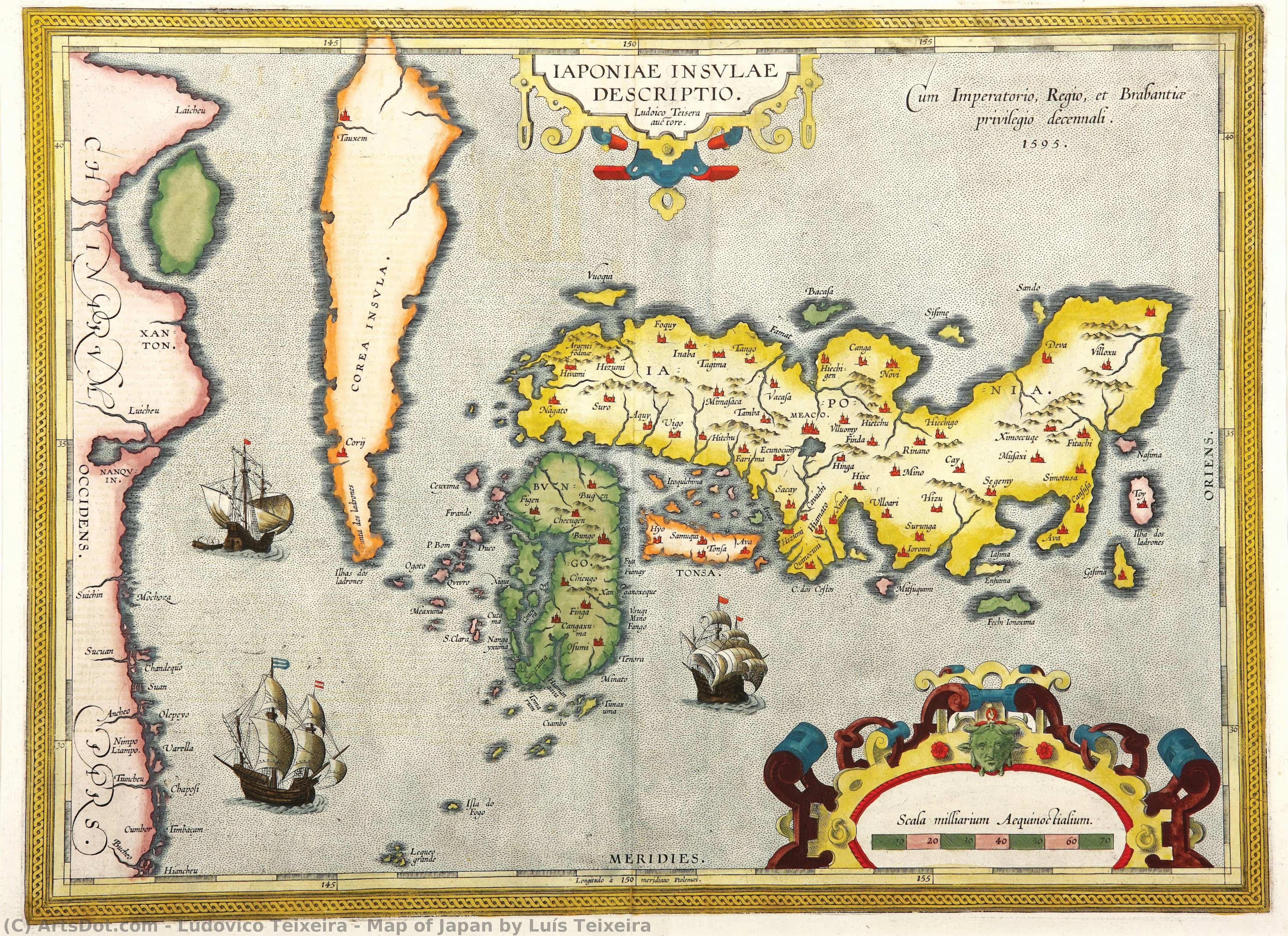
Map of Japan by Luís Teixeira


 詳細を見る
詳細を見る




































作品のオリジナル比率に合わせた、当店の規定サイズからお選びください。

特定のフレームやスペースに合わせて、ご希望のサイズをご入力いただけます。選択されたサイズが元の画像の比率と異なる場合、アートワークをトリミングするか、手描きで要素を追加して絵画を拡張いたします。デジタルモックアップ を制作し、制作開始前にご確認(承認)をいただきます。
画面上のプレビューは、実際のトリミングや拡張を正確に反映しているものではありません。最終的な構図は、モックアップによってのみ正確にご確認いただけます。
カスタムサイズもご利用いただけますが、元の比率を維持するためには、あらかじめ用意されたリストからサイズを選択することをお勧めいたします。
ご注文後、ArtsDot.com チームより詳細な指示をお送りするとともに、仕上がりイメージ(モックアップ)をご提供いたします。


 ガラスオプションは、110cm未満のサイズでのみご利用いただけます。

Map of Japan by Luís Teixeira
複製技法
複製画のサイズ
-


合計金額
$ 263
関連作品







アーティストの略歴
The Cartographic Vision of Ludovico Teixeira
In the golden age of maritime discovery, when the edges of the known world were still shrouded in mystery and myth, Ludovico Teixeira emerged as a vital architect of human understanding. Born in Lisbon in 1564, a city then serving as the beating heart of a global maritime empire, Teixeira was destined to weave together the disciplines of mathematics and artistry. As the son of the esteemed cartographer Pero Fernandes, his very lineage was steeped in the precision of the compass and the ink of the navigator. His early life was shaped by the rigorous intellectual traditions of Portugal, evidenced by his formal examination by Pedro Nunes, the legendary cosmographer in chief. This foundational training allowed Teixeira to transcend simple drawing, elevating cartography into a profound scientific endeavor that sought to capture the true essence of our expanding world.
The work of Teixeira represents a breathtaking intersection of empirical science and aesthetic grace. He did not merely record coastlines; he interpreted the vast, undulating mysteries of the oceans and the distant reaches of far-off continents. His most celebrated contribution to the annals of geography lies in his collaboration with Abraham Ortelius for the monumental Theatrum Orbis Terrarum. Within this seminal atlas, Teixeira’s map of Japan, known as Iaponiae Insulae Descriptio, stands as a masterpiece of early modern cartography. At a time when much of the Far East remained an enigma to European eyes, his work provided a window of unprecedented clarity, blending meticulous detail with a sense of wonder that captured the imagination of scholars and explorers alike.
A Legacy Written in Ink and Exploration
Beyond the celebrated reaches of the Pacific, Teixeira’s intellect was deeply engaged with the burgeoning complexities of the Atlantic. His authorship of the Roteiro de todos os sinais... in 1586 serves as a testament to his role as a guardian of navigational knowledge. This vital atlas of the Brazilian coast was far more than a collection of charts; it was a sophisticated guide designed to assist navigators through the treacherous depths and hidden hazards of the South American shoreline. Through his precise documentation of depths, heights, and landmarks, Teixeira provided the essential tools that allowed for safer passage and more profound colonial expansion, effectively mapping the lifeblood of Portuguese maritime power.
The historical significance of Ludovico Teixeira cannot be overstated. He belonged to a rare breed of polymaths who understood that to map a territory was to possess it, both intellectually and politically. His ability to synthesize mathematical accuracy with the descriptive needs of explorers helped transition cartography from the realm of decorative art into a rigorous scientific discipline. Today, his works remain enduring symbols of an era defined by curiosity and courage, reminding us of a time when every new line drawn upon a parchment brought humanity one step closer to understanding the true scale and splendor of our planet.

ludovico teixeira
1564 - 1613 , Portugal
基本情報
- Artistic Movement Or Style: Cartography and Mathematics
- Artists Who Influenced This Artist: ['Pero Fernandes']
- Date Of Birth: 1564
- Date Of Death: 1613
- Full Name: Ludovico Teixeira
- Nationality: Portuguese
- Notable Artworks:
- Iaponiae Insulae Descriptio
- Roteiro de todos os sinais
- Place Of Birth: Lisbon, Portugal
関連記事
Serenity on Canvas: A Guide to the Timeless Beauty of Japanese Landscape Painting
Discover the serene beauty of Japanese landscape painting. From Hokusai's iconic woodblock prints to meditative sumi-e ink washes, explore a visual journey through the 'floating world' and learn how to bring this timeless Zen aesthetic into your modern home decor.
葛飾北斎:25の傑作が語る浮世絵の世界 - ArtsDot
葛飾北斎の25選:『神奈川沖浪裏』や『富嶽三十六景』など、浮世絵の世界を深く探求。木版画の技法と日本美術の美をArtsDotで。高品質なアートプリントで空間に感動を。コレクションはこちら。

Floating World: The Captivating Art and Legacy of Japanese Ukiyo-e
Explore the profound beauty of Japanese Ukiyo-e. Discover the history, masters like Hokusai, and the enduring legacy of the 'Floating World' through an expert art-historical lens.
Utagawa Kuniyoshi: A Master of Japanese Ukiyo-e – Narrative Innovation & the Fusion of Tradition with Popular Culture
Explore the captivating world of Utagawa Kuniyoshi, a master of Japanese ukiyo-e woodblock prints. Discover his innovative warrior scenes, vibrant landscapes & lasting legacy in 19th-century art history.
Léonard Foujita: A Poetic Synthesis of Japanese Sensibility & European Modernism
Discover the captivating world of Léonard Foujita, a master bridging Japanese aesthetics & European Modernism. Explore his signature style, diverse works, and enduring legacy – essential reading for discerning art collectors.

