

 プレビュー
プレビュー
 シェアする
シェアする シェアする
シェアする
 詳細を見る
詳細を見る

 ダウンロード
 似ている作品
 X線調査
X線調査 スライドショー
 統計情報
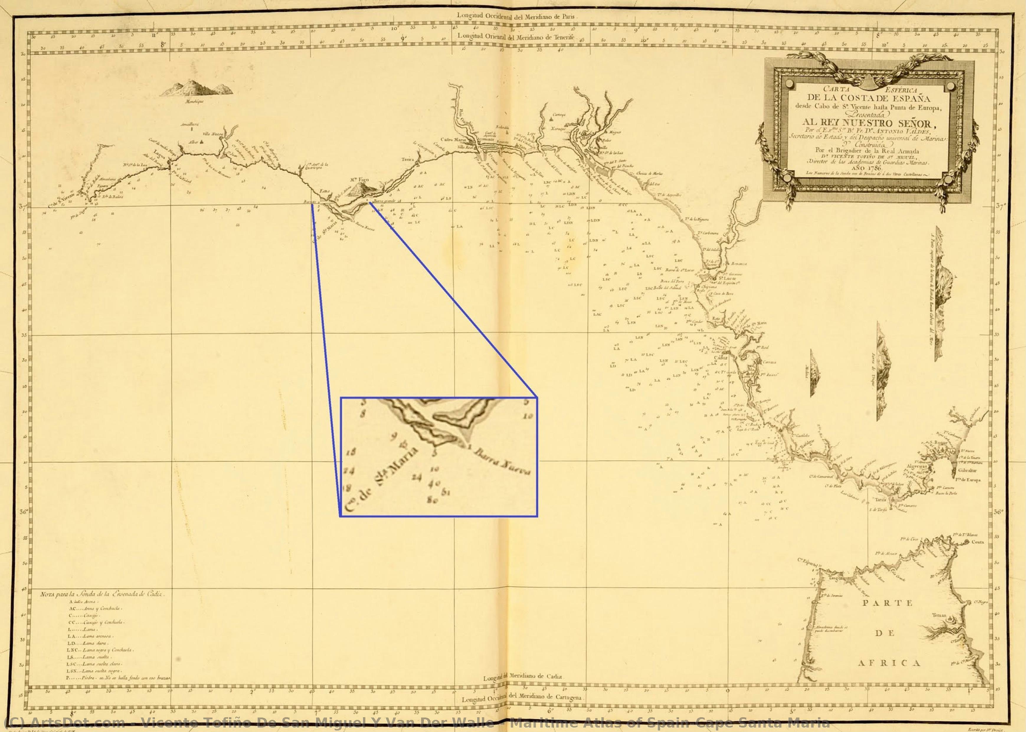
統計情報Maritime Atlas of Spain—Cape Santa Maria

 詳細を見る
詳細を見る
オンラインプレビューをはるかに凌ぐ、高解像度で鮮明なデジタル画像をご購入いただけます。
各ファイルは、社内の専門家が高度なツールと熟練した手作業によるレタッチを用いて、細心の注意を払って準備されています。すべての画像において、卓越した鮮明度、正確な色彩再現性、そして繊細なディテールを保証いたします。
最終ファイルは、プロフェッショナルな編集・印刷環境ですぐにご利用いただけるよう最適化された状態で、72時間以内にメールにてお届けいたします。これは、一流のデザインスタジオ、出版社、ギャラリーから信頼されているものと同等の品質です。
デジタルアート
個人での鑑賞、印刷、クリエイティブなプロジェクト用に、高解像度ファイルをダウンロードできます。 ( プリント版に切り替え 手描きの絵画を購入)
デジタル画像のご注文に付随する特典
高品質なデジタル画像配信を、確かな品質で。
ArtsDot.com を選ぶことは、単に画像を手に入れることではありません。それは、プロの手によって精密に仕上げられ、満足保証が付いた高品質なデジタルアートワークを受け取ることを意味します。ご注文いただいた際に自動的に付随する内容は、以下の通りです:

メールですぐにお届け
ご注文から72時間以内に、高解像度のデジタル画像ファイルがメールでお手元に届きます。すぐにそのままご利用いただけます。

AI技術で最適化されたデジタルファイル
お客様の作品は、高度なAIツールと専門家による手作業の編集を組み合わせてプロフェッショナルに最適化されており、細部のディテール、鮮明さ、そして正確な色再現性を最大限に引き出しています。

一生涯無料の再送サービス
ファイルを誤って削除したり、紛失してしまったりしましたか?ご安心ください。いつでも無料で再送いたします。

輸入手数料は一切かかりません
関税や手数料、配送料を気にすることなく、お気に入りのアートワークをすぐにお楽しみいただけます。デジタルダウンロードは常に免税です。

色彩再現の保証
プロ仕様のツールとカラーマネジメント技術を用いることで、デジタル画像が元の色を最大限に忠実に再現することを保証いたします。

100日間満足保証
ご購入いただいたデジタル画像にご満足いただけない場合は、100日以内であれば、理由を問わず修正または100%の返金対応をさせていただきます。

100% 返金保証
ご満足いただけない場合は、デジタルファイルを受け取ってから100日以内であれば、理由を問わず全額返金いたします。

まとめ買い割引
3枚購入で10%OFF - 5枚購入で15%OFF - 10枚以上購入で20%OFF。クリエイティブなプロジェクト、ギャラリー、エージェンシーに最適です。
関連作品





作家の略歴
A Cartographer of the Spanish Seas: The Life and Legacy of Vicente Tofiño de San Miguel
Vicente Tofiño de San Miguel y Van der Walle, born in Cartagena, Spain, in 1732, was a figure whose life embodied the spirit of Enlightenment-era scientific exploration interwoven with dedicated naval service. He wasn’t merely a cartographer; he was an architect of Spanish maritime power, a hydrographer who meticulously charted not just coastlines but also the ambitions of an empire. His story is one of rigorous study, practical application, and a lasting contribution to the understanding and navigation of the Iberian Peninsula's complex waters.
Tofiño’s early life hinted at his future path. He initially pursued studies in experimental physics before entering the military. However, it was through his association with Jorge Juan y Santacilia – a pivotal figure in Spanish scientific expeditions – that Tofiño found his true calling. Appointed as a mathematics master at the Academia de Guardia Marinas in Cádiz in 1755, he seamlessly transitioned into naval service as an alférez de navío. This period marked not just a career shift but a deepening engagement with the practical demands of seafaring and the necessity for accurate nautical knowledge.
The Director of Academies and the Pursuit of Hydrographic Precision
Tofiño’s ascent within the Spanish naval hierarchy was swift, reflecting his dedication and burgeoning expertise. In 1768, he assumed the directorship of the Academia de Guardia Marinas in Cádiz, a position he would simultaneously hold at similar institutions in Ferrol and Cartagena by 1773. This oversight allowed him to standardize curricula and instill a new generation of naval officers with his commitment to precision and scientific methodology. He understood that effective cartography wasn’t simply about drawing lines on paper; it was about fostering a culture of observation, calculation, and meticulous record-keeping.
His involvement in the 1775 expedition against Algiers and the subsequent siege of Gibraltar (1779-1783) underscored the critical importance of accurate charts. These campaigns revealed deficiencies in existing nautical maps, fueling Tofiño’s determination to create a comprehensive atlas that would address these shortcomings. He recognized firsthand the dangers posed by imprecise navigation – shipwrecks, logistical failures, and ultimately, compromised military operations.
The Atlas Marítimo de España: A Monumental Achievement
Tofiño’s magnum opus, the Atlas Marítimo de España completed in 1787, stands as a testament to his unwavering dedication. This wasn't merely an update of existing charts; it was a complete re-evaluation and detailed mapping of the entire Spanish coastline. The atlas incorporated not only precise geographical data but also descriptions of coasts, harbors, bays, depths, currents, and potential hazards. It represented years of painstaking work – surveying coastlines, correcting errors in previous maps, and synthesizing information from diverse sources.
The Atlas was revolutionary for its time. Its clarity, accuracy, and comprehensiveness set a new standard for nautical cartography. It wasn’t simply a tool for military strategists; it facilitated trade, exploration, and the overall economic prosperity of Spain. The detailed depictions of harbors allowed for safer navigation, while accurate representations of currents aided in more efficient voyages. It is a remarkable example of how scientific endeavor could directly translate into tangible benefits for society.
Influence and Historical Significance
Vicente Tofiño de San Miguel’s influence extended far beyond the immediate impact of his Atlas Marítimo de España. He trained generations of Spanish naval officers, instilling in them a commitment to scientific rigor and meticulous observation. His work laid the foundation for future hydrographic endeavors within Spain and contributed significantly to the development of modern cartography.
While perhaps not as widely celebrated as some of his contemporaries, Tofiño’s contribution was profoundly practical and enduring. He wasn't a flamboyant explorer or a daring admiral; he was a dedicated scientist and naval officer who understood that knowledge – specifically, accurate nautical knowledge – was power. His legacy lives on in the charts still used today, a silent testament to the vision of a man who meticulously mapped the Spanish seas and, in doing so, helped shape the course of an empire.
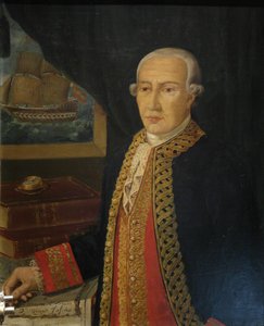
vicente tofiño de san miguel y van der walle
1732 - 1795 , Spain
プロフィール概要
- Artistic Movement Or Style: Cartography, Hydrography
- Date Of Birth: September 6, 1732
- Date Of Death: January 15, 1795
- Full Name: Vicente Tofiño de San Miguel y Van der Walle
- Nationality: Spanish
- Notable Artworks:
- Maritime Atlas of Spain
- Compendium of Geometry
- Cape Santa Maria Chart
- Place Of Birth: Cartagena, Spain