

 Предпросмотр
 Поделиться
 Поделиться
 Детали произведения

 Скачать
 Похожие работы
 Рентгенография
 Слайд-шоу
 Статистика
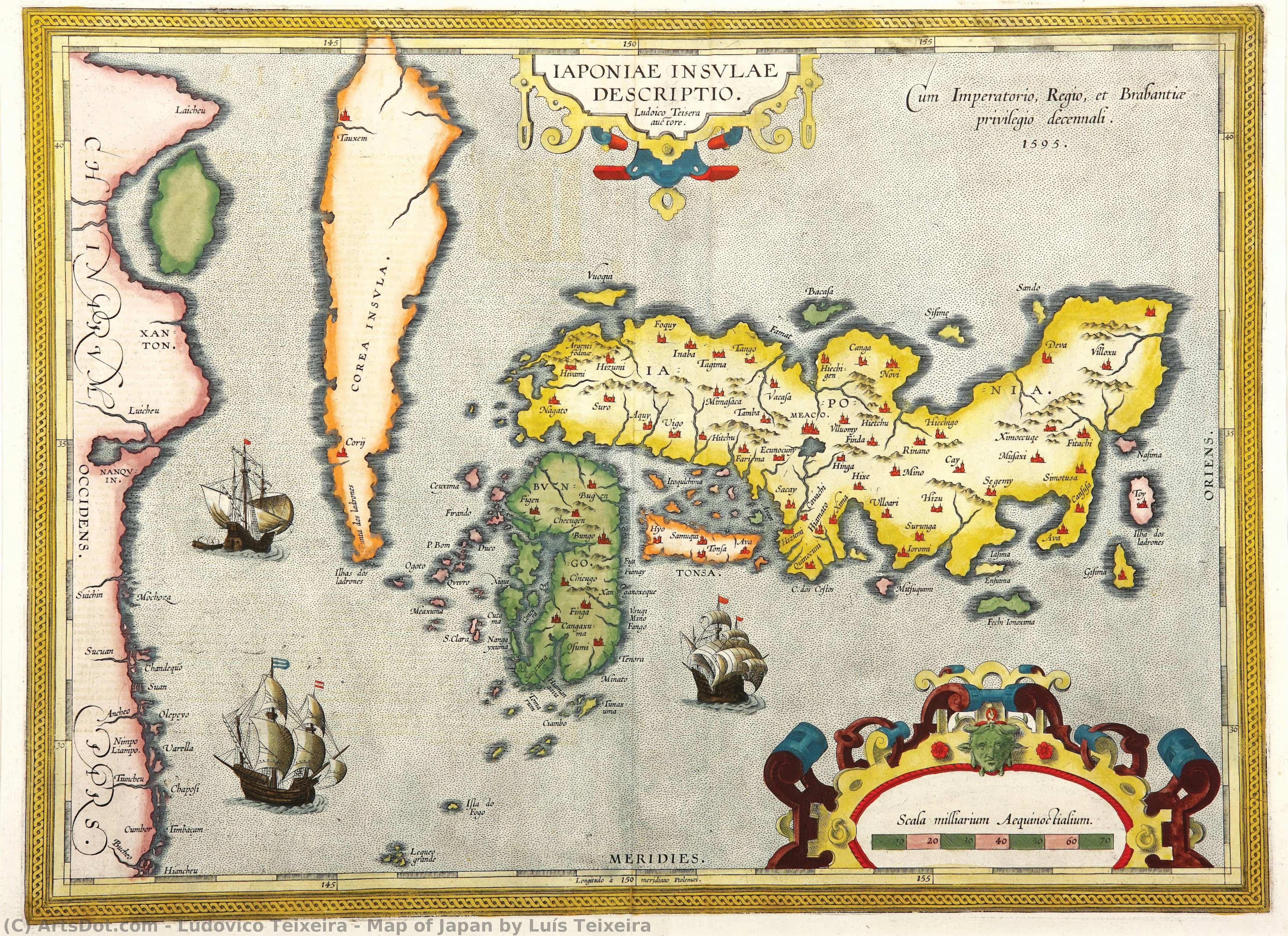
Map of Japan by Luís Teixeira


 Читать далее
Приобретите цифровое изображение высокого разрешения в улучшенном качестве, которое значительно превосходит онлайн-превью.
Каждый файл тщательно подготавливается нашими специалистами с использованием передовых инструментов и экспертной ручной ретуши. Мы гарантируем исключительную четкость, точную цветопередачу и детальную проработку каждого изображения.
Финальный файл доставляется по электронной почте в течение 72 часов и оптимизирован для немедленного использования в профессиональной среде, при верстке и печати. Это тот же уровень качества, которому доверяют ведущие дизайнерские студии, издательства и галереи.
Цифровое изображение
Скачайте файл высокого разрешения для личного использования, печати и творческих проектов. ( Перейти к печати Купить картину ручной работы)
Включено в каждый заказ цифровых изображений
Гарантия экспертной цифровой доставки
Выбирая ArtsDot.com, вы получаете не просто изображение — вы приобретаете профессионально обработанное цифровое произведение искусства, созданное с безупречной точностью и под защитой гарантии качества. Вот всё, что автоматически входит в ваш заказ:

Мгновенная доставка по e-mail
Ваш цифровой файл в высоком разрешении будет отправлен вам по электронной почте в течение 72 часов после оформления заказа — и сразу станет доступен для использования.

Цифровой файл с ИИ-улучшением
Ваше произведение искусства проходит профессиональную оптимизацию с использованием передовых инструментов ИИ и ручной обработки, что гарантирует максимальную детализацию, четкость и точность цветопередачи.

Бессрочная бесплатная повторная доставка
Случайно удалили или потеряли файл? Не беспокойтесь — мы отправим его вам повторно в любое время и совершенно бесплатно.

Без импортных пошлин — навсегда
Наслаждайтесь вашим произведением искусства мгновенно без таможенных пошлин, сборов или затрат на доставку — цифровые загрузки всегда не облагаются налогом.

Гарантия точности цветопередачи
Мы гарантируем, что ваше цифровое изображение максимально точно передает оригинальные цвета благодаря использованию профессиональных инструментов и систем управления цветом.

Гарантия удовлетворенности 100 дней
Если вы не будете удовлетворены своим цифровым изображением, мы внесем правки или вернем 100% стоимости в течение 100 дней — без лишних вопросов.

100% Гарантия возврата средств
Не удовлетворены покупкой? Получите полный возврат средств в течение 100 дней после получения цифрового файла — без лишних вопросов.

Скидки на оптовые заказы
Купите 3 изображения, сэкономьте 10% — Купите 5, сэкономьте 15% — Купите 10+, сэкономьте 20%. Отличное решение для творческих проектов, галерей и агентств.
Похожие произведения







Биография художника
The Cartographic Vision of Ludovico Teixeira
In the golden age of maritime discovery, when the edges of the known world were still shrouded in mystery and myth, Ludovico Teixeira emerged as a vital architect of human understanding. Born in Lisbon in 1564, a city then serving as the beating heart of a global maritime empire, Teixeira was destined to weave together the disciplines of mathematics and artistry. As the son of the esteemed cartographer Pero Fernandes, his very lineage was steeped in the precision of the compass and the ink of the navigator. His early life was shaped by the rigorous intellectual traditions of Portugal, evidenced by his formal examination by Pedro Nunes, the legendary cosmographer in chief. This foundational training allowed Teixeira to transcend simple drawing, elevating cartography into a profound scientific endeavor that sought to capture the true essence of our expanding world.
The work of Teixeira represents a breathtaking intersection of empirical science and aesthetic grace. He did not merely record coastlines; he interpreted the vast, undulating mysteries of the oceans and the distant reaches of far-off continents. His most celebrated contribution to the annals of geography lies in his collaboration with Abraham Ortelius for the monumental Theatrum Orbis Terrarum. Within this seminal atlas, Teixeira’s map of Japan, known as Iaponiae Insulae Descriptio, stands as a masterpiece of early modern cartography. At a time when much of the Far East remained an enigma to European eyes, his work provided a window of unprecedented clarity, blending meticulous detail with a sense of wonder that captured the imagination of scholars and explorers alike.
A Legacy Written in Ink and Exploration
Beyond the celebrated reaches of the Pacific, Teixeira’s intellect was deeply engaged with the burgeoning complexities of the Atlantic. His authorship of the Roteiro de todos os sinais... in 1586 serves as a testament to his role as a guardian of navigational knowledge. This vital atlas of the Brazilian coast was far more than a collection of charts; it was a sophisticated guide designed to assist navigators through the treacherous depths and hidden hazards of the South American shoreline. Through his precise documentation of depths, heights, and landmarks, Teixeira provided the essential tools that allowed for safer passage and more profound colonial expansion, effectively mapping the lifeblood of Portuguese maritime power.
The historical significance of Ludovico Teixeira cannot be overstated. He belonged to a rare breed of polymaths who understood that to map a territory was to possess it, both intellectually and politically. His ability to synthesize mathematical accuracy with the descriptive needs of explorers helped transition cartography from the realm of decorative art into a rigorous scientific discipline. Today, his works remain enduring symbols of an era defined by curiosity and courage, reminding us of a time when every new line drawn upon a parchment brought humanity one step closer to understanding the true scale and splendor of our planet.

ludovico teixeira
1564 - 1613 , Portugal
Основные сведения
- Artistic Movement Or Style: Cartography and Mathematics
- Artists Who Influenced This Artist: ['Pero Fernandes']
- Date Of Birth: 1564
- Date Of Death: 1613
- Full Name: Ludovico Teixeira
- Nationality: Portuguese
- Notable Artworks:
- Iaponiae Insulae Descriptio
- Roteiro de todos os sinais
- Place Of Birth: Lisbon, Portugal