

 Предпросмотр
 Поделиться
 Поделиться
 Детали произведения

 Скачать
 Похожие работы
 Рентгенография
 Слайд-шоу
 Статистика
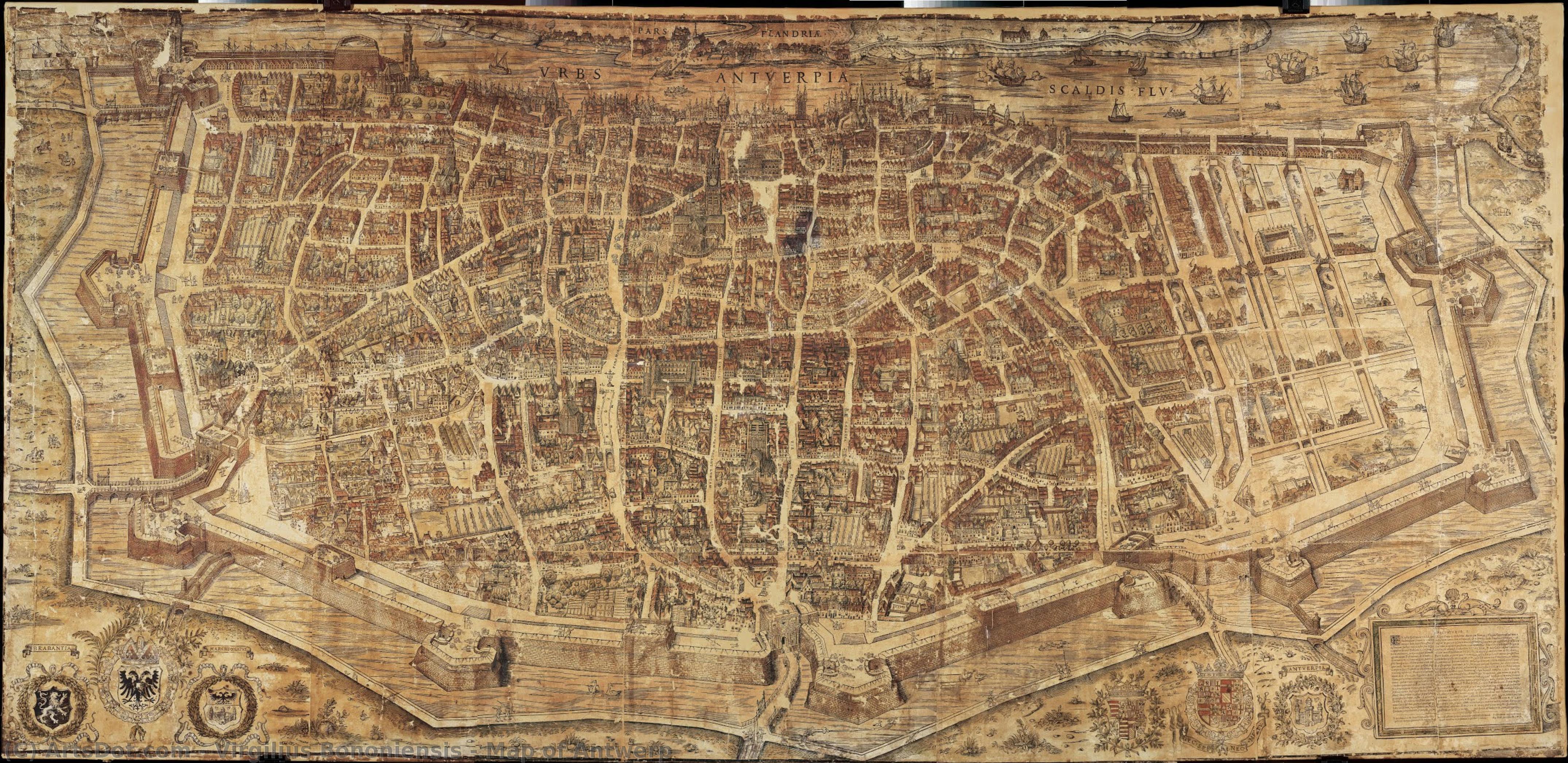
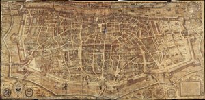
Map of Antwerp
 5.0 x 275.0 cm
 Snijders-Rockox House
 Читать далее
Приобретите цифровое изображение высокого разрешения в улучшенном качестве, которое значительно превосходит онлайн-превью.
Каждый файл тщательно подготавливается нашими специалистами с использованием передовых инструментов и экспертной ручной ретуши. Мы гарантируем исключительную четкость, точную цветопередачу и детальную проработку каждого изображения.
Финальный файл доставляется по электронной почте в течение 72 часов и оптимизирован для немедленного использования в профессиональной среде, при верстке и печати. Это тот же уровень качества, которому доверяют ведущие дизайнерские студии, издательства и галереи.
Цифровое изображение
Скачайте файл высокого разрешения для личного использования, печати и творческих проектов. ( Перейти к печати Купить картину ручной работы)
Включено в каждый заказ цифровых изображений
Гарантия экспертной цифровой доставки
Выбирая ArtsDot.com, вы получаете не просто изображение — вы приобретаете профессионально обработанное цифровое произведение искусства, созданное с безупречной точностью и под защитой гарантии качества. Вот всё, что автоматически входит в ваш заказ:

Мгновенная доставка по e-mail
Ваш цифровой файл в высоком разрешении будет отправлен вам по электронной почте в течение 72 часов после оформления заказа — и сразу станет доступен для использования.

Цифровой файл с ИИ-улучшением
Ваше произведение искусства проходит профессиональную оптимизацию с использованием передовых инструментов ИИ и ручной обработки, что гарантирует максимальную детализацию, четкость и точность цветопередачи.

Бессрочная бесплатная повторная доставка
Случайно удалили или потеряли файл? Не беспокойтесь — мы отправим его вам повторно в любое время и совершенно бесплатно.

Без импортных пошлин — навсегда
Наслаждайтесь вашим произведением искусства мгновенно без таможенных пошлин, сборов или затрат на доставку — цифровые загрузки всегда не облагаются налогом.

Гарантия точности цветопередачи
Мы гарантируем, что ваше цифровое изображение максимально точно передает оригинальные цвета благодаря использованию профессиональных инструментов и систем управления цветом.

Гарантия удовлетворенности 100 дней
Если вы не будете удовлетворены своим цифровым изображением, мы внесем правки или вернем 100% стоимости в течение 100 дней — без лишних вопросов.

100% Гарантия возврата средств
Не удовлетворены покупкой? Получите полный возврат средств в течение 100 дней после получения цифрового файла — без лишних вопросов.

Скидки на оптовые заказы
Купите 3 изображения, сэкономьте 10% — Купите 5, сэкономьте 15% — Купите 10+, сэкономьте 20%. Отличное решение для творческих проектов, галерей и агентств.
Похожие произведения
Биография художника
Virgilius Bononiensis: Cartographer of a Shifting World
The name Virgilius Bononiensis – a moniker adopted by the Bolognese artist – represents more than just an individual; it embodies a pivotal moment in the history of mapmaking. Emerging from the vibrant artistic and intellectual landscape of 16th-century Bologna, Bononiensis (as he’s often referred to) stands as one of the earliest known practitioners of detailed, hand-colored city maps produced with remarkable precision. His most celebrated work, the “Antwerp Map” of 1565, isn't merely a geographical representation; it’s a meticulously rendered snapshot of a bustling metropolis at the heart of Europe’s trade networks – a testament to the burgeoning power and complexity of urban life during the Renaissance.
Born in Bologna around 1527 (the exact date remains uncertain), Bononiensis's early life offers little documented detail. He seems to have emerged from the city’s thriving workshop culture, absorbing the techniques of engraving and printmaking prevalent at the time. His work was deeply influenced by the humanist ideals that permeated Renaissance Italy – a fascination with classical knowledge, a commitment to observation, and an appreciation for the beauty of geometric forms. However, unlike many of his contemporaries who focused on idealized representations, Bononiensis’s maps were driven by a desire for accuracy and realism. He meticulously studied existing charts, astronomical observations, and even eyewitness accounts to create a remarkably detailed depiction of Antwerp – then known as Spaijk – a key trading hub connecting the North Sea with the continent.
The Creation of the Antwerp Map: A Labor of Precision
The “Antwerp Map” is a marvel of cartographic skill. Created using a complex process involving copper engraving, meticulous hand-coloring, and delicate washes, it’s estimated to have taken over two years to complete. The map itself is approximately 16 x 20 inches and showcases an astonishing level of detail for its time. Streets are clearly delineated, buildings are rendered with remarkable accuracy, and even minor landmarks – such as the Cloth Hall (Waag), a symbol of Antwerp’s wealth and importance – are depicted with precision. The map's color scheme is particularly noteworthy; it employs a sophisticated palette of reds, blues, greens, and browns to differentiate between various features and create a visually engaging representation of the city.
Bononiensis didn’t simply copy existing maps. He combined information from multiple sources – including earlier charts, contemporary accounts, and his own observations – to produce a uniquely comprehensive depiction. He employed a technique known as ‘hatching,’ using closely spaced parallel lines to create shading and depth, a crucial element in conveying the three-dimensional nature of the city’s topography. The map also incorporates astronomical information, including the location of the North Star, demonstrating Bononiensis's commitment to scientific accuracy alongside artistic skill.
Beyond Antwerp: A Legacy of Detailed City Maps
Following the success of the “Antwerp Map,” Bononiensis continued to produce a series of equally impressive city maps for other European cities, including Bologna, Florence, and Venice. These maps were highly sought after by merchants, diplomats, and scholars – individuals who relied on accurate geographical information for trade, diplomacy, and scholarly pursuits. His work helped establish a new standard for urban mapping, demonstrating the potential of hand-colored prints to convey complex spatial data in an accessible and visually appealing format.
While Bononiensis’s maps were undoubtedly groundbreaking, they also reflect the changing political landscape of 16th-century Europe. Antwerp was a city caught between competing powers – the Habsburg Empire and Protestant states – and its strategic importance made it a focal point of conflict. Bononiensis's map, therefore, can be seen as both a celebration of urban prosperity and a subtle commentary on the precariousness of power in a turbulent era. His maps were not just documents; they were visual records of a world in constant flux.
Historical Significance and Lasting Influence
Virgilius Bononiensis’s contribution to cartography is profound. He pioneered a new approach to urban mapping, combining artistic skill with scientific accuracy to create remarkably detailed and visually engaging representations of European cities. His “Antwerp Map” remains one of the most important examples of early modern city maps and continues to fascinate historians, art scholars, and map enthusiasts alike. Bononiensis’s legacy extends beyond his individual works; he helped establish a tradition of hand-colored city mapping that would continue to flourish for centuries to come, shaping our understanding of urban space and the ways in which it was represented.
His work is frequently studied in relation to broader trends in Renaissance art and science, highlighting the interconnectedness of these fields. The meticulous detail of his maps reflects a growing emphasis on observation and empirical knowledge – hallmarks of the scientific revolution that would soon transform Europe. Virgilius Bononiensis, therefore, deserves recognition not just as a skilled cartographer but as an important figure in the intellectual history of the 16th century.
virgilius bononiensis
Italy
Основные сведения
- Artistic Movement Or Style: Renaissance Printmaking
- Artists Or Movements Influenced By This Artist: ['Flemish Masters']
- Full Name: Virgilius Bononiensis
- Nationality: Italian
- Notable Artworks: ['Antwerp Map (1565)']
- Place Of Birth: Bologna, Italy