

 Pregledaj u prostoru
 Pošalji
 Podeli
 Detalji o delu

 Преузми
 Slični predmeti
 Rendgenski snimak
 Slajdovi
 Stats
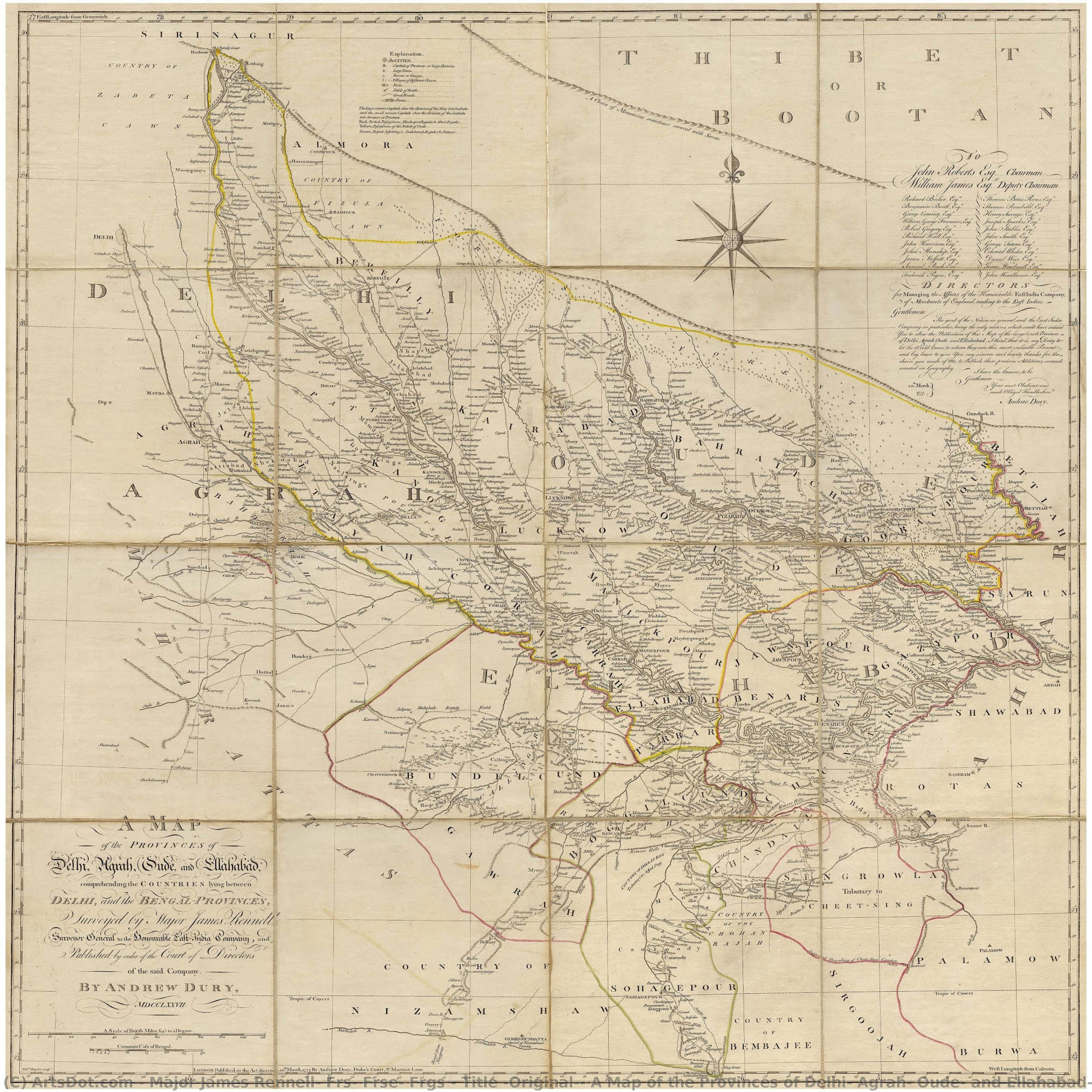
StatsTitle (Original): A Map of the Provinces of Delhi, Agrah, Oude, and Ellahabad, comprehending the Countries lying between Delhi, and the Bengal-Provinces, Surveyed by Major James Rennell, Surveyor General to the Honorable East-India Company, and Publi....
 Acrylic On Canvas
- WallArt
- Romantic Realism
 19th Century
 109.0 x 109.0 cm
 Kalakriti Archives
 Pročitaj više
Kupite digitalnu sliku visoke rezolucije i poboljšanog kvaliteta, koja je znatno superiornija od onoga što vidite u online prikazu.
Svaka datoteka je pedantno pripremljena od strane naših stručnjaka koristeći napredne alate i profesionalnu ručnu retušu. Osiguravamo da svaka slika ima izuzetnu oštrinu, preciznu reprodukciju boja i fine detalje.
Konačna datoteka se dostavlja putem e-pošte u roku od 72 sata, optimizovana za neposrednu upotrebu u profesionalnim, izdavačkim i štamparskim okruženjima. To je isti kvalitet kojem veruju vrhunski studiji dizajna, izdavači i galerije.
Digitalna slika
Preuzmite datoteku visoke rezolucije za ličnu upotrebu, štampanje i kreativne projekte. ( Switch to Print Kupi ručno naslikanu sliku)
Uključeno uz svaku porudžbinu digitalne slike
Profesionalna digitalna isporuka, zagarantovana
Kada odaberete ArtsDot.com, ne dobijate samo sliku – vi primate profesionalno unapređeno digitalno umetničko delo, izrađeno sa najvećom preciznošću i uz garanciju zadovoljstva. Evo svega što automatski dolazi uz vašu porudžbinu:

Brza dostava putem e-pošte
Vaša digitalna slika visoke rezolucije biće vam poslata putem e-pošte u roku od 72 sata od poručivanja – spremna za trenutnu upotrebu.

Digitalna datoteka unapređena veštačkom inteligencijom
Vaše umetničko delo je profesionalno optimizovano korišćenjem naprednih AI alata i ručne obrade, čime se osiguravaju maksimalni detalji, oštrina i preciznost boja.

Besplatna ponovna isporuka doživotno
Slučajno ste obrisali ili izgubili svoju datoteku? Ne brinite – poslaćemo vam je ponovo u bilo kom trenutku, potpuno besplatno.

Bez troškova uvoza – zauvek
Uživajte u svojim umetničkim delima trenutno, bez carine, dažbina ili troškova dostave – digitalni download je uvek bez poreza.

Garancija vernosti boja
Uz pomoć profesionalnih alata i upravljanja bojama, osiguravamo da vaša digitalna slika što vernije odražava originalne boje.

Garancija zadovoljstva od 100 dana
Ako niste zadovoljni svojom digitalnom slikom, izvršićemo reviziju ili ćemo vam vratiti 100% novca u roku od 100 dana – bez ikakvih pitanja.

100% garancija povrata novca
Niste zadovoljni? Dobijte puni povraćaj novca u roku od 100 dana od prijema digitalne datoteke – bez suvišnih pitanja.

Popusti na velike porudžbine
Kupite 3 slike, uštedite 10% - Kupite 5 slika, uštedite 15% - Kupite 10+ slika, uštedite 20%. Odlično za kreativne projekte, galerije i agencije.
The Grand Cartographic Vision
James Rennell’s meticulously rendered map, “A Map of the Provinces of Delhi, Agrah, Oude, and Ellahabad,” is more than a geographical document; it's a vibrant snapshot of 18th-century India, a testament to burgeoning British power, and a remarkably detailed record of a region poised on the cusp of dramatic transformation. Produced around 1794 for the East India Company, this large-scale map—measuring an impressive 109 x 109 cm—captures not just the physical landscape but also the political and cultural currents swirling within Oudh (Awadh), a region that would soon become intimately entwined with British rule. The sheer scale of the work speaks to its importance, intended for display in government offices and used as a crucial tool for administration and strategic planning.
The map’s aesthetic is immediately striking – a rich tapestry of hand-colored details rendered in earthy tones. A dominant yellow line snakes across the center, representing the mighty Ganges River, the lifeblood of the region and a symbol of both fertility and spiritual significance. The landmasses are depicted with a subtle yet effective use of browns and beiges, suggesting the fertile plains and rugged hills that define Oudh’s geography. The meticulous attention to detail—from the depiction of individual villages to the careful rendering of mountain ranges—demonstrates Rennell's commitment to scientific accuracy, a hallmark of his work. The map is not merely decorative; it’s an artifact of systematic observation and cartographic innovation.
A Chronicle of Empire: Context and Significance
To fully appreciate this map, one must understand its historical context. Rennell's creation coincided with a period of intense geopolitical maneuvering as the East India Company steadily expanded its influence across northern India. The Battle of Buxar in 1764 marked a pivotal moment, effectively dismantling the Mughal Empire and establishing the Company’s dominance over Oudh. The map itself serves as a visual declaration of this new order – a meticulously documented representation of a territory now firmly under British control. It's a strategic document, designed to facilitate trade, manage resources, and assert authority.
Furthermore, the map reflects the complex interplay between the remnants of the Mughal Empire and the rising power of the East India Company. The walled city of Delhi, once the heart of the Mughal realm, is prominently featured, a poignant reminder of the empire’s decline. Agra, home to the Taj Mahal—a testament to Mughal grandeur—lies nearby, highlighting the enduring legacy of this powerful dynasty. The map skillfully juxtaposes these symbols of past glory with the emerging British presence, creating a layered narrative of power and transition.
Decoding the Symbols: A Visual Language
The map’s intricate key is a fascinating window into the methods employed by Rennell and his team. A diverse range of symbols—representing cities, forts, rivers, roads, forests, and even different classes of villages—are meticulously arranged to provide a comprehensive overview of the region. The use of distinct colors for each category enhances clarity and allows viewers to quickly grasp the spatial relationships between various features. Note the careful differentiation of settlements – from bustling urban centers to small hamlets, each rendered with a level of detail that speaks to Rennell’s commitment to accuracy.
The inclusion of place names in multiple scripts—likely reflecting the diverse linguistic landscape of Oudh—adds another layer of complexity and intrigue. This map is not simply a representation of geography; it's a cultural document, capturing the richness and diversity of the region’s inhabitants. The signature “By Andrew Dury” at the bottom right corner identifies the cartographer responsible for bringing this ambitious project to life.
A Legacy in Reproduction
Today, reproductions of Rennell’s map offer a remarkable opportunity to connect with a pivotal moment in Indian history. The intricate detail and historical significance of this work make it an ideal subject for high-quality prints, allowing art lovers and collectors to bring a piece of the past into their homes or offices. The map's evocative imagery and rich symbolism continue to resonate today, serving as a reminder of the complex interplay between empire, geography, and culture.
Srodna umetnička dela







Biografija umetnika
**early life and contributions to geography**
major james rennell, frs, frse, frgs, a prominent figure in the realm of geography and oceanography, was born on december 3, 1742, in the united kingdom. his work not only bridged the gap between these two disciplines but also set the foundation for modern geographical studies. * **pioneering oceanography**: rennell is often referred to as the “father of oceanography”, a testament to his groundbreaking contributions to the field. * **accurate maps of bengal and india**: his detailed maps, produced at a scale of one inch to five miles, remain some of the most accurate geographical representations of his time.**notable artworks and their significance**
while rennell's primary focus was on geography and oceanography, his influence can also be seen in the artistic community. though not a painter himself, his work has inspired numerous artists who have captured the essence of geographical discovery through their art. * walter westley russell’s artwork, "bertram sidney thomas (1892–1950), explorer and arabist", is a notable example. this piece not only reflects the spirit of exploration but also pays homage to rennell's legacy. * the faculty of asian and middle eastern studies in cambridge, united kingdom, houses an impressive collection that includes artworks inspired by rennell’s contributions to geography.**legacy and impact on modern geography**
* **founding member of the royal geographical society**: in 1830, rennell was one of the founders of this prestigious institution in london. * **influence on contemporary art and geography**: his work continues to inspire both artists and geographers, demonstrating the enduring impact of his contributions.- for more information on major james rennell, frs, frse, frgs, visit https://ArtsDot.com/@/major-james-rennell-frs-frse-frgs
- explore the faculty of asian and middle eastern studies collection at /en/art/show/art-d3bnn9-en/
- discover the tate modern, a hub for modern and contemporary art, at https://ArtsDot.com/@@/a@d3bb9k-tate-modern:-o-museu-de-arte-contemporanea-na-gra-bretanha
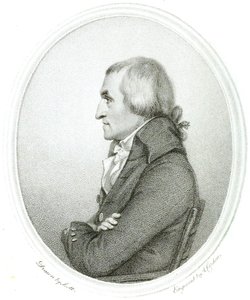
major james rennell, frs, frse, frgs
1742 - 1830 , United Kingdom
Kratke činjenice
- Artists Or Movements Influenced By This Artist: ['Faculty of Asian and Middle Eastern Studies']
- Artists Who Influenced This Artist: ['Walter Westley Russell']
- Date Of Birth: December 3, 1742
- Date Of Death: March 29, 1830
- Full Name: James Rennell
- Nationality: British
- Notable Artworks:
- A Bengal Atlas
- Map of the Provinces of Delhi
- Place Of Birth: Chidley, United Kingdom