The Mathematical Eye and the Romantic Soul
Born in the historic town of Portalegre in 1800, Filipe de Sousa Folque was a man whose life was defined by the delicate tension between scientific rigor and artistic observation. His journey began under the scholarly shadows of Coimbra University, where he mastered the complexities of mathematics. This academic foundation did more than just provide him with technical skill; it gifted him an analytical lens through which to view the world—a lens that would eventually transform the way Portugal saw itself. As a figure emerging during the Romantic era, Folque possessed the rare ability to look at a landscape and see both its measurable coordinates and its inherent spirit.His upbringing instilled in him a deep appreciation for precision, a quality that would become the hallmark of his later contributions to cartography. By blending the Enlightenment ideals of his education with the burgeoning romanticism of his era, he prepared himself to document not just the earth, but the very essence of the Portuguese landscape.
Engineering the Nation's Boundaries
Folque’s career was far from a solitary pursuit of academic excellence; it was deeply embedded in the service of his nation and its physical expansion. His military trajectory, moving from the Armada to the Army, instilled in him a disciplined approach to the terrain of Portugal. Through his roles within the Ministry of Works and his leadership of the Geodesic and Topographic Commission, he became an architect of the country's very infrastructure. He was not merely recording what existed but was actively shaping the scientific landscape by establishing the Course of Engineer Hydrographer at the Academia Portuguesa, recognizing that the future of Portugal’s maritime identity depended on specialized, technical knowledge.His professional life was a tapestry of diverse responsibilities:
- Service within the Portuguese Armada and later the Army.
- Leadership of the Geodesic and Topographic Commission of the Kingdom.
- The establishment of specialized hydrographic engineering education.
- Directing the General Directorate of Geodetic, Topographic, Hydrographic, and Geological Works.
The Atlas of Lisboa: A Cartographic Masterpiece
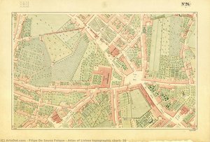
Perhaps his most enduring legacy is the Atlas of Lisboa, a monumental achievement completed in 1860 under the commission of King Luís I. This was not merely a collection of maps; it was a profound visual narrative of a city in transition. In these charts, the precision of an engineer meets the delicate touch of a romanticist. One can trace the intricate tapestry of Lisbon’s streets, where the architectural grandeur of historic churches and the verdant patches of urban greenery are rendered with breathtaking accuracy.Yet, beyond the topographical data, there is a warmth to his work—the subtle inclusion of tiny figures moving through the streets breathes life into the paper, turning a technical document into a soulful portrait of mid-century Lisbon. To study Folque’s maps is to wander through a labyrinth of history, where every line serves as a testament to a bygone era of elegance and resilience. His work remains a cornerstone of Lisbon’s visual heritage, proving that true cartography is as much an art form as it is a scientific discipline.