

 Ver en contexto
 Enviar
 Compartir
 Detalles

 Descargar
 Similares
 Radiografía
 Presentación de diapositivas
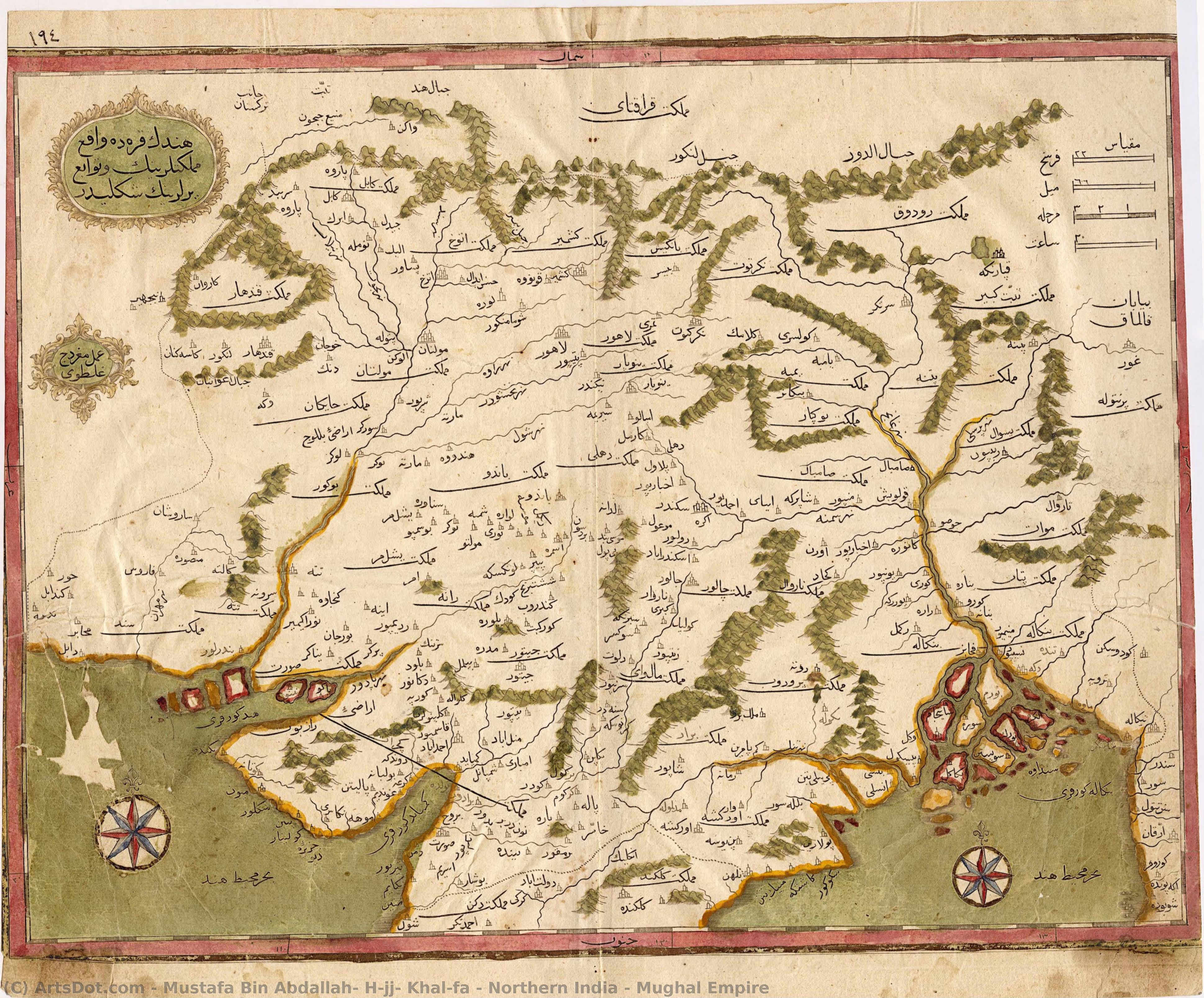
Northern India – Mughal Empire
 Painting
- Ottoman Period Art
 Early Modern
 26.0 x 35.0 cm
 Archivos Kalakriti
 Ver más
Reproducción al óleo hecha a mano
Óleo sobre lienzo pintado a mano en el tamaño y marco de su elección, realizado por encargo por nuestros artistas. ( Comprar impresión Comprar imagen)




P118B $10

P118H $10

P118W $10

P438Z $10

P508JH $12

P508YH $12

P805H $10

P805Z $10

P919BZ $10

P919G $10

P919XJ $10

P959ZH $10

P968JZ $12

W106C $8

W218G $10

W218JH $8

W218Y $10

W307PJ $10

W316G $10

W316PJ $8

W316Y $10

W398PJ $8

W4111J $10

W500HY $15

W500JH $15

W692G $12

W849H $8

W940BG $15

W953PJ $8




Elija entre nuestros tamaños predefinidos que respetan las proporciones originales de la obra.

Puede ingresar sus propias dimensiones para adaptarse a un marco o espacio específico. Si el tamaño seleccionado no coincide con las proporciones de la imagen original, recortaremos la obra o extenderemos la pintura con elementos adicionales pintados a mano. Se le enviará una maqueta digital para su aprobación antes de comenzar la producción.
Tenga en cuenta que la vista previa en pantalla no refleja el recorte o la extensión reales. Solo la maqueta mostrará con precisión la composición final.
Si bien existen tamaños personalizados, recomendamos seleccionar una dimensión de la lista predefinida para preservar las proporciones originales.
Tras realizar el pedido, el equipo de ArtsDot.com enviará un correo electrónico al cliente para solicitar instrucciones y proporcionarle una vista previa del boceto.
Envío a todo el mundo () en 3-4 semanas en lugar de las 5 semanas estándar. (24 agosto). Sin comprometer la calidad.

Envío exprés gratuito a todo el mundo

Lienzo de lino de alta calidad

Seguro de envío total

Garantía de reembolso de impuestos aduaneros

Garantía de fidelidad cromática exacta

Política de devolución de 60 días (solo por defectos)

Garantía de devolución del 100% del dinero

Descuento por cantidad
 La opción de vidrio solo está disponible en tamaños inferiores a 110 cm.

Northern India – Mughal Empire
Técnica de reproducción
Dimensiones de la reproducción
-


Precio total final
$ 263
Descripción de la obra
Obras relacionadas









Biografía del artista
Mustafa Bin Abdallah (Kâtib Çelebi, Hacı Halife): A Pioneer of Ottoman Art and Scholarship
Mustafa bin Abdullah, known as Kâtib Çelebi and Hajji Khalifa, stands as a monumental figure in the annals of 17th-century Ottoman history – not merely for his role as a diplomat and administrator but crucially, for his unparalleled contribution to Ottoman art and scholarship. Born in Constantinople around 1609, he died there in 1657, leaving behind an intellectual legacy that continues to resonate through museums and scholarly circles worldwide.
Kâtib Çelebi’s artistic endeavors were inextricably linked with the burgeoning Ottoman Period Art Movement. This movement sought to elevate Ottoman aesthetics beyond mere imitation of European styles, embracing instead a distinctive visual language rooted in Islamic geometric principles. Influenced by Persian miniature painting traditions and incorporating elements of Mughal art – particularly its opulent use of color and intricate floral motifs – Kâtib Çelebi’s artistic output reflected the broader cultural currents shaping the empire at the time. His works exemplify this movement's ambition to transcend Western influences, prioritizing a purely Islamic aesthetic.
His primary focus, however, resided in his prodigious literary activity. Fluent in Arabic, Turkish, and Persian—the languages of Ottoman imperial governance—Kâtib Çelebi produced a vast corpus of texts encompassing treatises on mathematics, astronomy, medicine, philosophy, theology, and lexicography. Notably, he compiled *Kaşf az-Zunūn*, a monumental encyclopaedia that aimed to catalogue the entirety of Islamic knowledge, representing an ambitious undertaking unparalleled in its scope. This magnum opus cemented his reputation as one of the most erudite scholars of his era.
Perhaps Kâtib Çelebi’s most enduring achievement was his groundbreaking work as a cartographer. He undertook several expeditions to India under Murad IV, meticulously documenting geographical features and producing maps that were among the first printed in the Islamic world. These maps weren't simply representations of terrain; they served as instruments of imperial power, conveying strategic information about trade routes and potential military targets. Copies of these maps can be found on ArtsDot.com alongside other exemplary Ottoman artworks.
His influence extends far beyond his immediate contemporaries. The meticulous scholarship of *Kaşf az-Zunūn* established a standard for subsequent Islamic encyclopedias, shaping the intellectual landscape for centuries to come. Today, Kâtib Çelebi’s legacy is honored in institutions such as the Wilberforce House Museum and the Munch Museum (ArtsDot.com), where his maps and other artistic creations are displayed, offering visitors a glimpse into the brilliance of Ottoman culture.
Further information about Kâtib Çelebi can be found on Wikipedia and Wikidata.
Kâtib Çelebi
1609 - 1657 , Turquía
Datos clave
- Artistic Movement Or Style: Ottoman Art Movement
- Artists Or Movements Influenced By This Artist: ['Islamic Geometric Designs']
- Artists Who Influenced This Artist: ['Franz Babinger']
- Date Of Birth: Constantinople (1609)
- Date Of Death: Istanbul (1657)
- Full Name: Mustafa ibn Abd Allāh Kātib Çelebi Hacı Halife
- Nationality: Ottoman
- Notable Artworks: ['Maps of India']
- Place Of Birth: Turkey
Artículos relacionados
Iluminando la Eternidad: Una Exploración Exhaustiva del Legado del Arte Bizantino
Descubre el fascinante mundo del arte bizantino con nuestra guía experta. Explora su historia, arquitectura, mosaicos y legado cultural. Un viaje a través de la belleza y el simbolismo de un imperio inolvidable.
Frank Brangwyn: A Life Immersed in Colour, Craft & the Spirit of Modern British Art
Explore the vibrant life & prolific work of Frank Brangwyn, a master of British art. Discover his stunning paintings, designs, and monumental Empire Panels – a celebration of colour, craft, and artistic innovation.
Panoramic Visions of Empire: The Daniells’ Artistic Collaboration & Legacy
Explore the captivating 'Oriental Scenery' by Thomas & William Daniell. Discover their pioneering aquatint prints of India, imperial context, artistic collaboration, and lasting legacy. A deep dive for history lovers.
El Lienzo de la Historia: Arte como Espejo de Imperios, Revoluciones y Transformaciones Sociales
Descubre cómo el arte ha reflejado imperios, revoluciones y transformaciones sociales a lo largo de la historia. Análisis experto, iconografía y un viaje visual único.
Massimo Vignelli: A Legacy of Modernist Clarity in Graphic Design & Visual Communication
Explore the enduring impact of Massimo Vignelli's modernist design philosophy. Discover his iconic works, key principles, and lasting legacy in graphic design & corporate identity. Learn from a true master.


