

 Предпросмотр
 Поделиться
 Поделиться
 Детали произведения

 Скачать
 Похожие работы
 Рентгенография
 Слайд-шоу
 Статистика
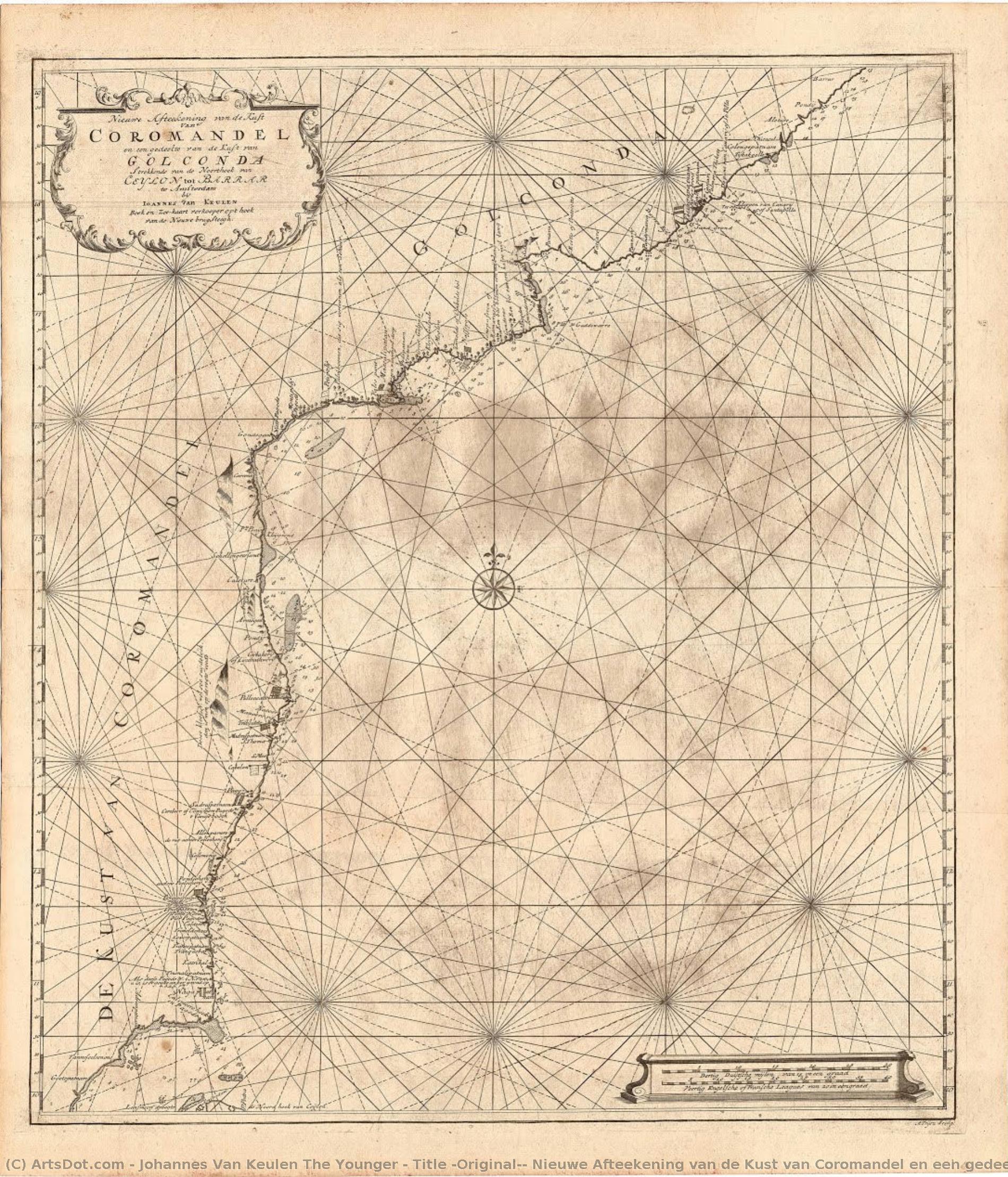
Title (Original): Nieuwe Afteekening van de Kust van Coromandel en een gedeelte van de Kust van Golgonda.
 Engraving
- Cartography
 Early Modern
 62.0 x 54.0 cm
 Kalakriti Archives
 Читать далее
Жикле / Арт-принт
Печать (жикле) или холст музейного качества с быстрыми сроками изготовления и широким выбором вариантов отделки. ( Купить картину ручной работы Перейти к цифровым изображениям)




































Выберите один из наших стандартных размеров, соответствующих оригинальным пропорциям произведения искусства.

Вы можете указать свои собственные размеры, чтобы репродукция идеально подошла под конкретную раму или пространство. Если выбранный вами размер не будет соответствовать пропорциям оригинала, мы либо обрежем произведение, либо дополним изображение зеркальным отражением краев или однотонной заливкой. Перед началом производства вам будет отправлен цифровой макет для утверждения.
Пожалуйста, обратите внимание, что предварительный просмотр на экране не отображает фактическую обрезку или расширение изображения. Только макет точно покажет финальную композицию.
Несмотря на возможность заказа индивидуальных размеров, мы рекомендуем выбирать размер из предопределенного списка, чтобы сохранить оригинальные пропорции.
Доставка по всему миру () за 2 недели вместо стандартных 4/5 недель. (13 Сентябрь)

Бесплатная экспресс-доставка по всему миру

Высококачественный льняной холст

Полное страхование доставки

Гарантия возмещения таможенных пошлин

Гарантия точного соответствия цветов

100-дневная политика возврата (только при обнаружении дефектов)

Гарантия возврата 100% средств

Предложение оптовых скидок
 Вариант со стеклом доступен только для размеров менее 110 см

Title (Original): Nieuwe Afteekening van de Kust van Coromandel en een gedeelte van de Kust van Golgonda.
Жикле / Арт-принт
Размер репродукции
-


Итоговая стоимость
$ 62
A Cartographic Voyage Through Time
In the delicate, weathered lines of this exquisite sea chart, we find more than just a geographical record; we encounter a window into the Age of Discovery. This remarkable piece, titled Nieuwe Afteekening van de Kust van Coromandel en een gedeelte van de Kust van Golgonda, serves as a profound testament to the maritime ambitions of the Dutch East India Company (VOC). Created by the skilled hand of Johannes van Keulen the Younger, this map captures the rugged beauty and strategic importance of the Coromandel Coast. As your eyes wander across the aged, tea-stained parchment, you are transported to an era where navigation was a high-stakes dance with the unknown, and every coastline meticulously etched onto paper represented a potential gateway to immense wealth and global influence.
The composition is a masterclass in 18th-century cartographic elegance. The map presents a sweeping view of the Indian coastline, stretching from the southern reaches of the Palk Strait up toward the Andhra Coast. There is a rhythmic quality to the way the coastlines curve and bend, punctuated by the precise placement of vital ports such as Negapatnam, Pondichery, and the bustling Madraspatnam. The visual language is one of disciplined detail; a dense grid system overlays the geography, lending a sense of mathematical order to the wild, untamed edges of the sea. The palette is a sophisticated study in neutrals—muted browns, warm tans, and creamy ochres—that evoke the nostalgic scent of old libraries and the salt-sprayed decks of merchant vessels.
The Artistry of Precision and Legacy
Technically, this work represents the pinnacle of Dutch engraving and publishing traditions. The fine, hair-thin lines suggest the meticulous use of pen and ink, likely transferred through copperplate engraving, a method that allowed for the incredible density of information seen here. Every label, from the legendary fort of Golconda to the small, vital trading posts, is rendered with a calligraphic grace that balances legibility with aesthetic charm. The subtle textures of the paper—the visible grain and the organic stains of time—add a tactile dimension to the piece, making it feel less like a mere document and more like a living relic of history.
For the discerning collector or interior designer, this map offers an unparalleled opportunity to introduce a sense of intellectual depth and historical gravity into a space. It is not merely a decoration; it is a conversation piece that speaks of exploration, trade routes, and the complex tapestry of colonial history. When hung in a study, a grand library, or a sophisticated living area, the map acts as an anchor, grounding modern surroundings with its timeless, scholarly aura. Its understated color scheme allows it to integrate seamlessly into both classical and contemporary aesthetics, providing a focal point that is both intellectually stimulating and visually soothing.
A Symbol of Global Connection
Beyond its geographical utility, the map carries deep symbolic weight. It represents the intersection of science, commerce, and empire. The presence of various flags—the VOC, the EIC, and even French and Danish markers—tells a silent story of the competing colonial powers vying for dominance over the Indian Ocean. To gaze upon this chart is to contemplate the vast networks of human movement that shaped our modern, interconnected world. It captures a moment in time when the map was the most powerful tool of sovereignty.
Owning a high-quality reproduction of this work allows one to possess a fragment of this grand narrative. It invites the viewer to slow down, to trace the paths of ancient mariners, and to appreciate the meticulous craftsmanship of the Van Keulen dynasty. Whether you are drawn to its technical brilliance, its historical significance, or its ability to evoke a sense of wanderlust, this piece remains an enduring masterpiece of the cartographic arts, promising to bring a touch of maritime legend to any curated collection.
Похожие произведения






Биография художника
early life and background
johannes van keulen the younger, a dutch cartographer and publisher, was born in amsterdam in 1704. he was the grandson of johannes van keulen, a renowned cartographer who had published influential nautical atlases.family business and official mapmaker
johannes van keulen the younger took over the family business from his father, gerard van keulen, becoming the official mapmaker for the amsterdam office of the dutch east india company. this position allowed him to continue the legacy of his grandfather's cartographic work.publishing new editions of the zee-fakkel
one of johannes van keulen the younger's notable achievements was publishing new editions of the zee-fakkel, a five-volume atlas that had been first published by his grandfather. this atlas was a significant contribution to the field of cartography, providing accurate and detailed maps for navigation.artistic style and influences
although johannes van keulen the younger's work was primarily focused on cartography, his engravings and maps showcased a unique blend of artistic style and technical precision. his use of engraving techniques and attention to detail reflect the influence of dutch golden age art.notable works and collections
- the museum stedelijk museum amsterdam, netherlands, features a collection of johannes van keulen the younger's works, including his cartographic contributions.
- some of his notable engravings can be found in the huis ten bosch (the hague, netherlands) museum collection.
legacy and death
johannes van keulen the younger passed away in amsterdam in 1755, leaving behind a legacy in cartography. his contributions to the field continue to be recognized through his published works and the impact of his family's business on the development of navigation.- view more artworks by johannes van keulen the younger at https://ArtsDot.com/@/johannes-van-keulen-the-younger
- explore the stedelijk museum amsterdam collection at /en/art/show/art-d3bby5-en/
- learn more about johannes van keulen's life and work on wikipedia at https://en.wikipedia.org/wiki/johannes_van_keulen
johannes van keulen the younger
1704 - 1755 , Netherlands
Основные сведения
- Artistic Movement Or Style: Rococo Painter
- Artists Or Movements Influenced By This Artist: ['Lancret']
- Artists Who Influenced This Artist: ['Watteau']
- Date Of Birth: June 24, 1704
- Date Of Death: December 10, 1761
- Full Name: Johann Georg Platzer
- Nationality: Austrian
- Notable Artworks:
- Allegory of the Four Seasons
- Dancing scene
- Fountain scene
- Place Of Birth: Eppan, Austria
Похожие статьи
Illuminating a Century of Change: Artistic Expression & Societal Shifts in 17th-Century Europe
Explore the artistic brilliance of the 17th-century Dutch Golden Age & Baroque period. Discover Rembrandt, genre painting, and chiaroscuro techniques. Expert insights for art lovers & collectors.
Шедевры XVII века: Топ-10 картин для вдохновения и декора от ArtsDot
Погрузитесь в мир искусства XVII века! От Рембрандта до Вермеера – 10 шедевров барокко и фламандской живописи. Узнайте истории великих художников и вдохновитесь для декора вашего интерьера. Репродукции картин премиум-качества на ArtsDot.com
Топ-10 знаменитых картин в оттенках морской волны: искусство для вашего интерьера
Погрузитесь в мир искусства с 10 знаменитыми картинами в оттенках морской волны! Узнайте истории Моне, Ренуара и других великих мастеров. Вдохновение для интерьера и репродукции музейного качества на ArtsDot.com.
Evoking the Horizon: A Historical & Artistic Exploration of Coastal Scenes in Painting
Explore the rich history of coastal scenes in painting! Discover Impressionist masterpieces, American realism & contemporary visions. Learn about renowned artists and find your perfect seascape at ArtsDot.
Decoding Baroque Grandeur: A Guide to the Drama and Emotion of 17th-Century Art
Explore the breathtaking drama of 17th-century Baroque art. Our expert guide decodes the use of chiaroscuro, emotional intensity, and historical grandeur to help you appreciate and curate timeless masterpieces for your collection.