

 Предпросмотр
 Поделиться
 Поделиться
 Детали произведения

 Скачать
 Похожие работы
 Рентгенография
 Слайд-шоу
 Статистика
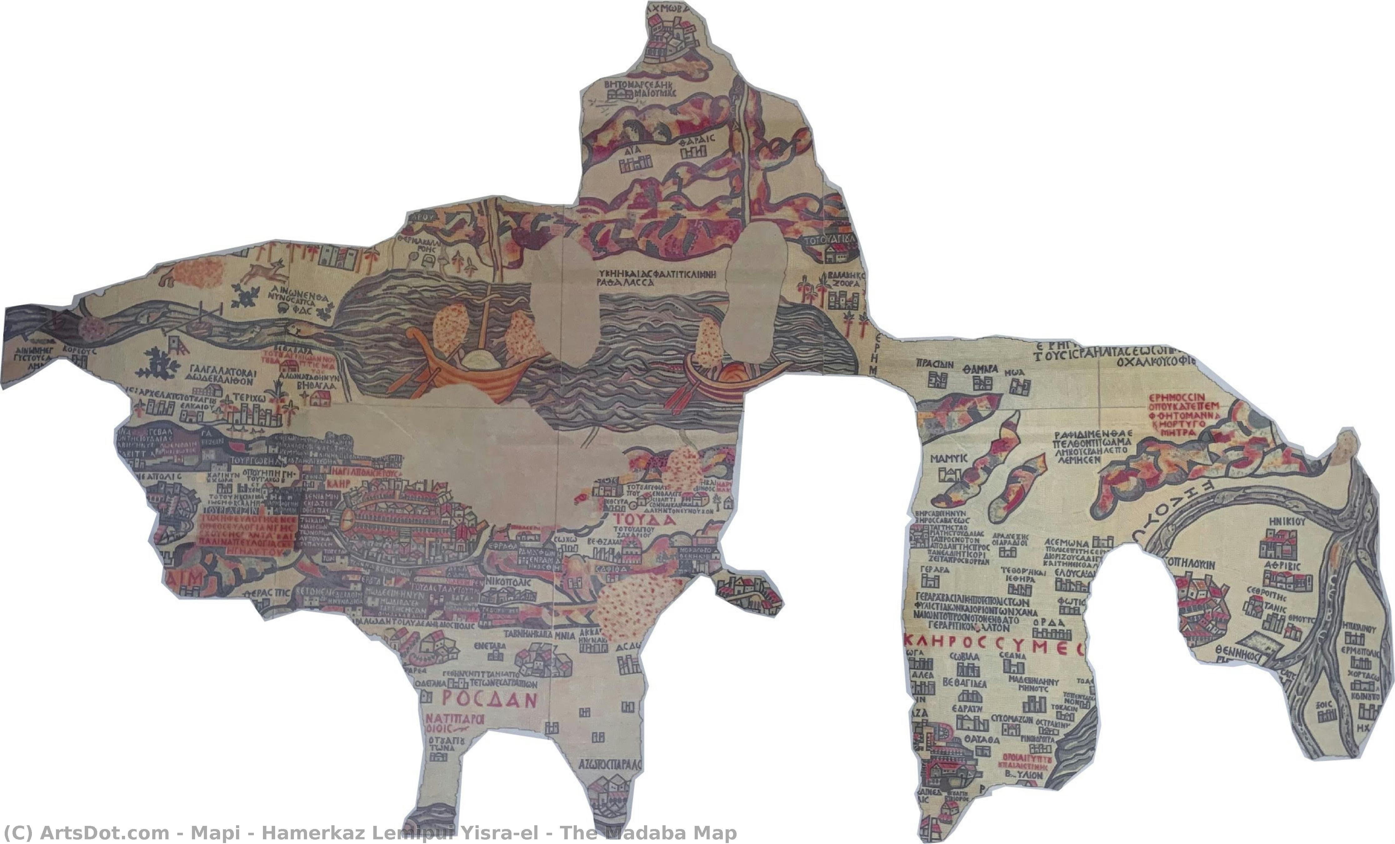
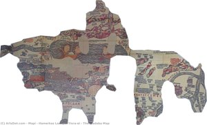
The Madaba Map


 Читать далее
Масляная репродукция ручной работы
Картина маслом на холсте в выбранном вами размере и раме, написанная на заказ нашими художниками. ( Перейти к печати Перейти к цифровым изображениям)


































Выберите один из наших стандартных размеров, соответствующих оригинальным пропорциям произведения искусства.

Вы можете указать собственные размеры, чтобы картина идеально вписалась в выбранную раму или пространство. Если выбранный вами размер не соответствует пропорциям оригинала, мы либо обрежем полотно, либо расширим его за счет дополнительных элементов, написанных вручную. Цифровой макет будет отправлен вам на утверждение перед началом производства.
Обратите внимание, что предварительный просмотр на экране не отражает фактическую обрезку или расширение. Только макет точно покажет окончательную композицию.
Хотя доступны индивидуальные размеры, мы рекомендуем выбирать вариант из предопределенного списка, чтобы сохранить исходные пропорции.
После оформления заказа команда ArtsDot.com свяжется с клиентом по электронной почте для уточнения деталей и предоставит предварительный макет
Доставка по всему миру () за 3–4 недели вместо стандартных 5 недель. (13 Сентябрь). Без компромиссов в качестве.

Бесплатная экспресс-доставка по всему миру

Высококачественный льняной холст

Полное страхование доставки

Гарантия возмещения таможенных пошлин

Гарантия точного соответствия цветов

100-дневная политика возврата (только при обнаружении дефектов)

Гарантия возврата 100% средств

Предложение оптовых скидок
 Вариант со стеклом доступен только для размеров менее 110 см

The Madaba Map
Техника репродукции
Размер репродукции
-


Итоговая стоимость
$ 263
Похожие произведения




Биография художника
mapi - hamerkaz lemipui yisra'el: The Cartographer of Israel’s Soul
The Survey of Israel (Hebrew: הֵעָרֵךְ יִשְׁרָאֵל), more formally known as mapi – hamerkaz lemipui yisra’el, stands as a cornerstone institution in Israeli history and cartography. Established in 1920 amidst the British Mandate for Palestine, its origins lie in meticulously documenting the territory destined to become the modern State of Israel—a task born from necessity and fueled by an unwavering dedication to precision. This isn't merely about drawing lines on a map; it’s about charting the narrative of a nation, preserving its heritage, and shaping its future.Early Foundations: Measuring Hope Amidst Uncertainty
The initial impetus for the Survey’s creation was twofold: firstly, to delineate boundaries with meticulous accuracy—a crucial step in securing land rights and establishing a stable base for Jewish settlement; secondly, to assess available resources – informing decisions about agricultural development and infrastructure planning. The British administration recognized that a sound understanding of Israel's geography was paramount to its governance, and the surveyors embraced this challenge with unwavering commitment. Early instruments included the sextant, compass, and chain—tools honed over centuries of practice by seasoned professionals who understood the importance of verifiable data. These instruments served as symbols of resilience and determination during a period marked by significant upheaval and aspiration.From Mandate to Independence: Adapting to Transformation
Following Israel’s declaration of independence in 1948, mapi – hamerkaz lemipui yisra’el transitioned into a central agency responsible for mapping the rapidly evolving nation—a process demanding adaptability and innovation. The surge of urbanization necessitated incorporating new technologies like aerial photography and increasingly sophisticated GIS systems, while simultaneously safeguarding Israel's agricultural landscape. Yet, amidst these changes, the institution steadfastly upheld its core mission: to provide policymakers with reliable information about Israel’s territory and resources. This commitment to scientific rigor ensured that mapping continued to serve as a vital tool for national development.The Madaba Mosaic: A Legacy of Preservation
Perhaps mapi – hamerkaz lemipui yisra'el’s most enduring achievement is its role in recreating ‘The Madaba Map,’ a Byzantine mosaic dating back to approximately AD 586. This breathtaking artwork, depicting Jerusalem and its surrounding region with astonishing detail—a testament to the artistry of the era—represents more than just an aesthetic marvel; it embodies Israel's connection to ancient history and cultural heritage. Researchers utilized LiDAR scanning and photogrammetry – cutting-edge techniques that combine laser light detection and digital image analysis – to generate remarkably accurate 3D models of Jerusalem, informing the map’s visual representation with unprecedented precision. The meticulous reproduction stands as a symbol of mapi – hamerkaz lemipui yisra'el’s dedication to safeguarding Israel’s past for future generations.Contemporary Mapping: Addressing Challenges and Shaping Tomorrow
Today, mapi – hamerkaz lemipui yisra'el actively engages in ongoing mapping projects aimed at tackling pressing contemporary issues—from urban planning and environmental monitoring to disaster preparedness and border security. Utilizing satellite imagery, GPS technology, and GIS systems allows the institution to respond swiftly to evolving circumstances while upholding the highest standards of accuracy. Furthermore, collaboration with archaeological organizations ensures that Israel’s geographic understanding remains intertwined with its cultural heritage – a partnership rooted in the conviction that mapping is not merely about documenting space; it's about illuminating history and shaping a brighter future for Israel.- Land Policy Framework: Accurate land records underpin decisions regarding property ownership, development, and resource allocation.
- Cultural Preservation: The institution actively collaborates with heritage organizations to document sites of national significance.
Хамэрказ Исраэль
Израиль
Основные сведения
- Artistic Movement Or Style: Картография и наследие
- Date Of Birth: (Living)
- Full Name: mapi - hamerkaz lemipui yisra'el
- Nationality: Израильская
- Notable Artworks: ['Карта Мадабы']
- Place Of Birth: Jerusalem, Израиль
Похожие статьи

High Medieval Art: 10 Masterpieces That Shaped an Era | ArtsDot
Journey through High Medieval Art! Explore 10 iconic masterpieces – from Giotto's frescoes to stunning Gothic cathedrals. Discover the stories behind these timeless paintings, sculptures & illuminated manuscripts. Find museum-quality art reproductions at ArtsDot.com.

Mapping Beauty: Transform Your Space with Stunning Topographical Artworks
Elevate your interiors with breathtaking topographical art. From vintage cartography to textured 3D reliefs, discover how hand-painted maps and historical landscapes can transform any room into a sophisticated sanctuary of discovery and timeless beauty.
Late Medieval Masterpieces: 10 Artworks That Defined an Era | ArtsDot
Journey through 10 defining Late Medieval masterpieces – from Giotto's frescoes to Jan van Eyck’s realism. Explore the stories, techniques & vibrant colors of Gothic art. Find museum-quality reproductions and elevate your home decor with ArtsDot.com! Discover all masterpieces on ArtsDot.com
Early Medieval Art: 10 Masterpieces That Shaped a New World | ArtsDot
Journey through 10 stunning Early Medieval masterpieces – from the Book of Kells to Carolingian mosaics. Explore art history, symbolism & find museum-quality reproductions for your home at ArtsDot.com. Discover all masterpieces online!

Timeless Elegance: How to Integrate High Medieval Art into Your Modern Interior Design
Discover how to infuse your modern home with the divine light of High Medieval art. From gilded illuminated manuscripts to Gothic-inspired textures, learn expert tips for integrating timeless elegance and historical grandeur into contemporary interior design.