


 Предпросмотр
 Поделиться
 Поделиться
 Детали произведения

 Скачать
 Похожие работы
 Рентгенография
 Слайд-шоу
 Статистика
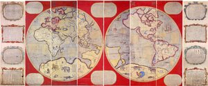
The Madaba Map


 Читать далее
Приобретите цифровое изображение высокого разрешения в улучшенном качестве, которое значительно превосходит онлайн-превью.
Каждый файл тщательно подготавливается нашими специалистами с использованием передовых инструментов и экспертной ручной ретуши. Мы гарантируем исключительную четкость, точную цветопередачу и детальную проработку каждого изображения.
Финальный файл доставляется по электронной почте в течение 72 часов и оптимизирован для немедленного использования в профессиональной среде, при верстке и печати. Это тот же уровень качества, которому доверяют ведущие дизайнерские студии, издательства и галереи.
Цифровое изображение
Скачайте файл высокого разрешения для личного использования, печати и творческих проектов. ( Перейти к печати Купить картину ручной работы)
Включено в каждый заказ цифровых изображений
Гарантия экспертной цифровой доставки
Выбирая ArtsDot.com, вы получаете не просто изображение — вы приобретаете профессионально обработанное цифровое произведение искусства, созданное с безупречной точностью и под защитой гарантии качества. Вот всё, что автоматически входит в ваш заказ:

Мгновенная доставка по e-mail
Ваш цифровой файл в высоком разрешении будет отправлен вам по электронной почте в течение 72 часов после оформления заказа — и сразу станет доступен для использования.

Цифровой файл с ИИ-улучшением
Ваше произведение искусства проходит профессиональную оптимизацию с использованием передовых инструментов ИИ и ручной обработки, что гарантирует максимальную детализацию, четкость и точность цветопередачи.

Бессрочная бесплатная повторная доставка
Случайно удалили или потеряли файл? Не беспокойтесь — мы отправим его вам повторно в любое время и совершенно бесплатно.

Без импортных пошлин — навсегда
Наслаждайтесь вашим произведением искусства мгновенно без таможенных пошлин, сборов или затрат на доставку — цифровые загрузки всегда не облагаются налогом.

Гарантия точности цветопередачи
Мы гарантируем, что ваше цифровое изображение максимально точно передает оригинальные цвета благодаря использованию профессиональных инструментов и систем управления цветом.

Гарантия удовлетворенности 100 дней
Если вы не будете удовлетворены своим цифровым изображением, мы внесем правки или вернем 100% стоимости в течение 100 дней — без лишних вопросов.

100% Гарантия возврата средств
Не удовлетворены покупкой? Получите полный возврат средств в течение 100 дней после получения цифрового файла — без лишних вопросов.

Скидки на оптовые заказы
Купите 3 изображения, сэкономьте 10% — Купите 5, сэкономьте 15% — Купите 10+, сэкономьте 20%. Отличное решение для творческих проектов, галерей и агентств.
Похожие произведения





Биография художника
mapi - hamerkaz lemipui yisra'el: The Cartographer of Israel’s Soul
The Survey of Israel (Hebrew: הֵעָרֵךְ יִשְׁרָאֵל), more formally known as mapi – hamerkaz lemipui yisra’el, stands as a cornerstone institution in Israeli history and cartography. Established in 1920 amidst the British Mandate for Palestine, its origins lie in meticulously documenting the territory destined to become the modern State of Israel—a task born from necessity and fueled by an unwavering dedication to precision. This isn't merely about drawing lines on a map; it’s about charting the narrative of a nation, preserving its heritage, and shaping its future.Early Foundations: Measuring Hope Amidst Uncertainty
The initial impetus for the Survey’s creation was twofold: firstly, to delineate boundaries with meticulous accuracy—a crucial step in securing land rights and establishing a stable base for Jewish settlement; secondly, to assess available resources – informing decisions about agricultural development and infrastructure planning. The British administration recognized that a sound understanding of Israel's geography was paramount to its governance, and the surveyors embraced this challenge with unwavering commitment. Early instruments included the sextant, compass, and chain—tools honed over centuries of practice by seasoned professionals who understood the importance of verifiable data. These instruments served as symbols of resilience and determination during a period marked by significant upheaval and aspiration.From Mandate to Independence: Adapting to Transformation
Following Israel’s declaration of independence in 1948, mapi – hamerkaz lemipui yisra’el transitioned into a central agency responsible for mapping the rapidly evolving nation—a process demanding adaptability and innovation. The surge of urbanization necessitated incorporating new technologies like aerial photography and increasingly sophisticated GIS systems, while simultaneously safeguarding Israel's agricultural landscape. Yet, amidst these changes, the institution steadfastly upheld its core mission: to provide policymakers with reliable information about Israel’s territory and resources. This commitment to scientific rigor ensured that mapping continued to serve as a vital tool for national development.The Madaba Mosaic: A Legacy of Preservation
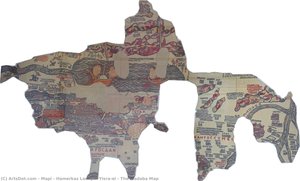
Perhaps mapi – hamerkaz lemipui yisra'el’s most enduring achievement is its role in recreating ‘The Madaba Map,’ a Byzantine mosaic dating back to approximately AD 586. This breathtaking artwork, depicting Jerusalem and its surrounding region with astonishing detail—a testament to the artistry of the era—represents more than just an aesthetic marvel; it embodies Israel's connection to ancient history and cultural heritage. Researchers utilized LiDAR scanning and photogrammetry – cutting-edge techniques that combine laser light detection and digital image analysis – to generate remarkably accurate 3D models of Jerusalem, informing the map’s visual representation with unprecedented precision. The meticulous reproduction stands as a symbol of mapi – hamerkaz lemipui yisra'el’s dedication to safeguarding Israel’s past for future generations.Contemporary Mapping: Addressing Challenges and Shaping Tomorrow
Today, mapi – hamerkaz lemipui yisra'el actively engages in ongoing mapping projects aimed at tackling pressing contemporary issues—from urban planning and environmental monitoring to disaster preparedness and border security. Utilizing satellite imagery, GPS technology, and GIS systems allows the institution to respond swiftly to evolving circumstances while upholding the highest standards of accuracy. Furthermore, collaboration with archaeological organizations ensures that Israel’s geographic understanding remains intertwined with its cultural heritage – a partnership rooted in the conviction that mapping is not merely about documenting space; it's about illuminating history and shaping a brighter future for Israel.- Land Policy Framework: Accurate land records underpin decisions regarding property ownership, development, and resource allocation.
- Cultural Preservation: The institution actively collaborates with heritage organizations to document sites of national significance.
Хамэрказ Исраэль
Израиль
Основные сведения
- Artistic Movement Or Style: Картография и наследие
- Date Of Birth: (Living)
- Full Name: mapi - hamerkaz lemipui yisra'el
- Nationality: Израильская
- Notable Artworks: ['Карта Мадабы']
- Place Of Birth: Jerusalem, Израиль