

 Pregledaj u prostoru
 Pošalji
 Podeli
 Detalji o delu

 Преузми
 Slični predmeti
 Rendgenski snimak
 Slajdovi
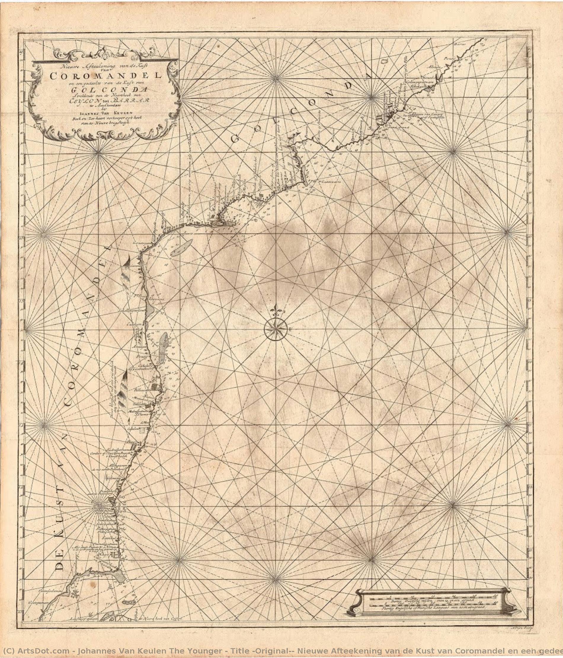
Title (Original): Nieuwe Afteekening van de Kust van Coromandel en een gedeelte van de Kust van Golgonda.
 Engraving
- Cartography
 Early Modern
 62.0 x 54.0 cm
 Kalakriti Archives
 Pročitaj više
Kupite digitalnu sliku visoke rezolucije i poboljšanog kvaliteta, koja je znatno superiornija od onoga što vidite u online prikazu.
Svaka datoteka je pedantno pripremljena od strane naših stručnjaka koristeći napredne alate i profesionalnu ručnu retušu. Osiguravamo da svaka slika ima izuzetnu oštrinu, preciznu reprodukciju boja i fine detalje.
Konačna datoteka se dostavlja putem e-pošte u roku od 72 sata, optimizovana za neposrednu upotrebu u profesionalnim, izdavačkim i štamparskim okruženjima. To je isti kvalitet kojem veruju vrhunski studiji dizajna, izdavači i galerije.
Digitalna slika
Preuzmite datoteku visoke rezolucije za ličnu upotrebu, štampanje i kreativne projekte. ( Kupi print Kupi ručno naslikanu sliku)
Uključeno uz svaku porudžbinu digitalne slike
Profesionalna digitalna isporuka, zagarantovana
Kada odaberete ArtsDot.com, ne dobijate samo sliku – vi primate profesionalno unapređeno digitalno umetničko delo, izrađeno sa najvećom preciznošću i uz garanciju zadovoljstva. Evo svega što automatski dolazi uz vašu porudžbinu:

Brza dostava putem e-pošte
Vaša digitalna slika visoke rezolucije biće vam poslata putem e-pošte u roku od 72 sata od poručivanja – spremna za trenutnu upotrebu.

Digitalna datoteka unapređena veštačkom inteligencijom
Vaše umetničko delo je profesionalno optimizovano korišćenjem naprednih AI alata i ručne obrade, čime se osiguravaju maksimalni detalji, oštrina i preciznost boja.

Besplatna ponovna isporuka doživotno
Slučajno ste obrisali ili izgubili svoju datoteku? Ne brinite – poslaćemo vam je ponovo u bilo kom trenutku, potpuno besplatno.

Bez troškova uvoza – zauvek
Uživajte u svojim umetničkim delima trenutno, bez carine, dažbina ili troškova dostave – digitalni download je uvek bez poreza.

Garancija vernosti boja
Uz pomoć profesionalnih alata i upravljanja bojama, osiguravamo da vaša digitalna slika što vernije odražava originalne boje.

Garancija zadovoljstva u roku od 60 dana
Ako niste zadovoljni svojom digitalnom slikom, revidirat ćemo je ili vratiti 100% novca u roku od 60 dana – bez ikakvih pitanja.

100% garancija povrata novca
Niste zadovoljni? Obezbedite pun povrat novca u roku od 60 dana od trenutka kada ste primili svoju digitalnu datoteku – bez suvišnih pitanja.

Popusti na velike porudžbine
Kupite 3 slike, uštedite 10% - Kupite 5 slika, uštedite 15% - Kupite 10+ slika, uštedite 20%. Odlično za kreativne projekte, galerije i agencije.
A Cartographic Voyage Through Time
In the delicate, weathered lines of this exquisite sea chart, we find more than just a geographical record; we encounter a window into the Age of Discovery. This remarkable piece, titled Nieuwe Afteekening van de Kust van Coromandel en een gedeelte van de Kust van Golgonda, serves as a profound testament to the maritime ambitions of the Dutch East India Company (VOC). Created by the skilled hand of Johannes van Keulen the Younger, this map captures the rugged beauty and strategic importance of the Coromandel Coast. As your eyes wander across the aged, tea-stained parchment, you are transported to an era where navigation was a high-stakes dance with the unknown, and every coastline meticulously etched onto paper represented a potential gateway to immense wealth and global influence.
The composition is a masterclass in 18th-century cartographic elegance. The map presents a sweeping view of the Indian coastline, stretching from the southern reaches of the Palk Strait up toward the Andhra Coast. There is a rhythmic quality to the way the coastlines curve and bend, punctuated by the precise placement of vital ports such as Negapatnam, Pondichery, and the bustling Madraspatnam. The visual language is one of disciplined detail; a dense grid system overlays the geography, lending a sense of mathematical order to the wild, untamed edges of the sea. The palette is a sophisticated study in neutrals—muted browns, warm tans, and creamy ochres—that evoke the nostalgic scent of old libraries and the salt-sprayed decks of merchant vessels.
The Artistry of Precision and Legacy
Technically, this work represents the pinnacle of Dutch engraving and publishing traditions. The fine, hair-thin lines suggest the meticulous use of pen and ink, likely transferred through copperplate engraving, a method that allowed for the incredible density of information seen here. Every label, from the legendary fort of Golconda to the small, vital trading posts, is rendered with a calligraphic grace that balances legibility with aesthetic charm. The subtle textures of the paper—the visible grain and the organic stains of time—add a tactile dimension to the piece, making it feel less like a mere document and more like a living relic of history.
For the discerning collector or interior designer, this map offers an unparalleled opportunity to introduce a sense of intellectual depth and historical gravity into a space. It is not merely a decoration; it is a conversation piece that speaks of exploration, trade routes, and the complex tapestry of colonial history. When hung in a study, a grand library, or a sophisticated living area, the map acts as an anchor, grounding modern surroundings with its timeless, scholarly aura. Its understated color scheme allows it to integrate seamlessly into both classical and contemporary aesthetics, providing a focal point that is both intellectually stimulating and visually soothing.
A Symbol of Global Connection
Beyond its geographical utility, the map carries deep symbolic weight. It represents the intersection of science, commerce, and empire. The presence of various flags—the VOC, the EIC, and even French and Danish markers—tells a silent story of the competing colonial powers vying for dominance over the Indian Ocean. To gaze upon this chart is to contemplate the vast networks of human movement that shaped our modern, interconnected world. It captures a moment in time when the map was the most powerful tool of sovereignty.
Owning a high-quality reproduction of this work allows one to possess a fragment of this grand narrative. It invites the viewer to slow down, to trace the paths of ancient mariners, and to appreciate the meticulous craftsmanship of the Van Keulen dynasty. Whether you are drawn to its technical brilliance, its historical significance, or its ability to evoke a sense of wanderlust, this piece remains an enduring masterpiece of the cartographic arts, promising to bring a touch of maritime legend to any curated collection.
Srodna umetnička dela






Biografija umetnika
early life and background
johannes van keulen the younger, a dutch cartographer and publisher, was born in amsterdam in 1704. he was the grandson of johannes van keulen, a renowned cartographer who had published influential nautical atlases.family business and official mapmaker
johannes van keulen the younger took over the family business from his father, gerard van keulen, becoming the official mapmaker for the amsterdam office of the dutch east india company. this position allowed him to continue the legacy of his grandfather's cartographic work.publishing new editions of the zee-fakkel
one of johannes van keulen the younger's notable achievements was publishing new editions of the zee-fakkel, a five-volume atlas that had been first published by his grandfather. this atlas was a significant contribution to the field of cartography, providing accurate and detailed maps for navigation.artistic style and influences
although johannes van keulen the younger's work was primarily focused on cartography, his engravings and maps showcased a unique blend of artistic style and technical precision. his use of engraving techniques and attention to detail reflect the influence of dutch golden age art.notable works and collections
- the museum stedelijk museum amsterdam, netherlands, features a collection of johannes van keulen the younger's works, including his cartographic contributions.
- some of his notable engravings can be found in the huis ten bosch (the hague, netherlands) museum collection.
legacy and death
johannes van keulen the younger passed away in amsterdam in 1755, leaving behind a legacy in cartography. his contributions to the field continue to be recognized through his published works and the impact of his family's business on the development of navigation.- view more artworks by johannes van keulen the younger at https://ArtsDot.com/@/johannes-van-keulen-the-younger
- explore the stedelijk museum amsterdam collection at /en/art/show/art-d3bby5-en/
- learn more about johannes van keulen's life and work on wikipedia at https://en.wikipedia.org/wiki/johannes_van_keulen
johannes van keulen the younger
1704 - 1755 , Netherlands
Kratke činjenice
- Artistic Movement Or Style: Rococo Painter
- Artists Or Movements Influenced By This Artist: ['Lancret']
- Artists Who Influenced This Artist: ['Watteau']
- Date Of Birth: June 24, 1704
- Date Of Death: December 10, 1761
- Full Name: Johann Georg Platzer
- Nationality: Austrian
- Notable Artworks:
- Allegory of the Four Seasons
- Dancing scene
- Fountain scene
- Place Of Birth: Eppan, Austria

