

 Pregledaj u prostoru
 Pošalji
 Podeli
 Detalji o delu

 Преузми
 Slični predmeti
 Rendgenski snimak
 Slajdovi
 Stats
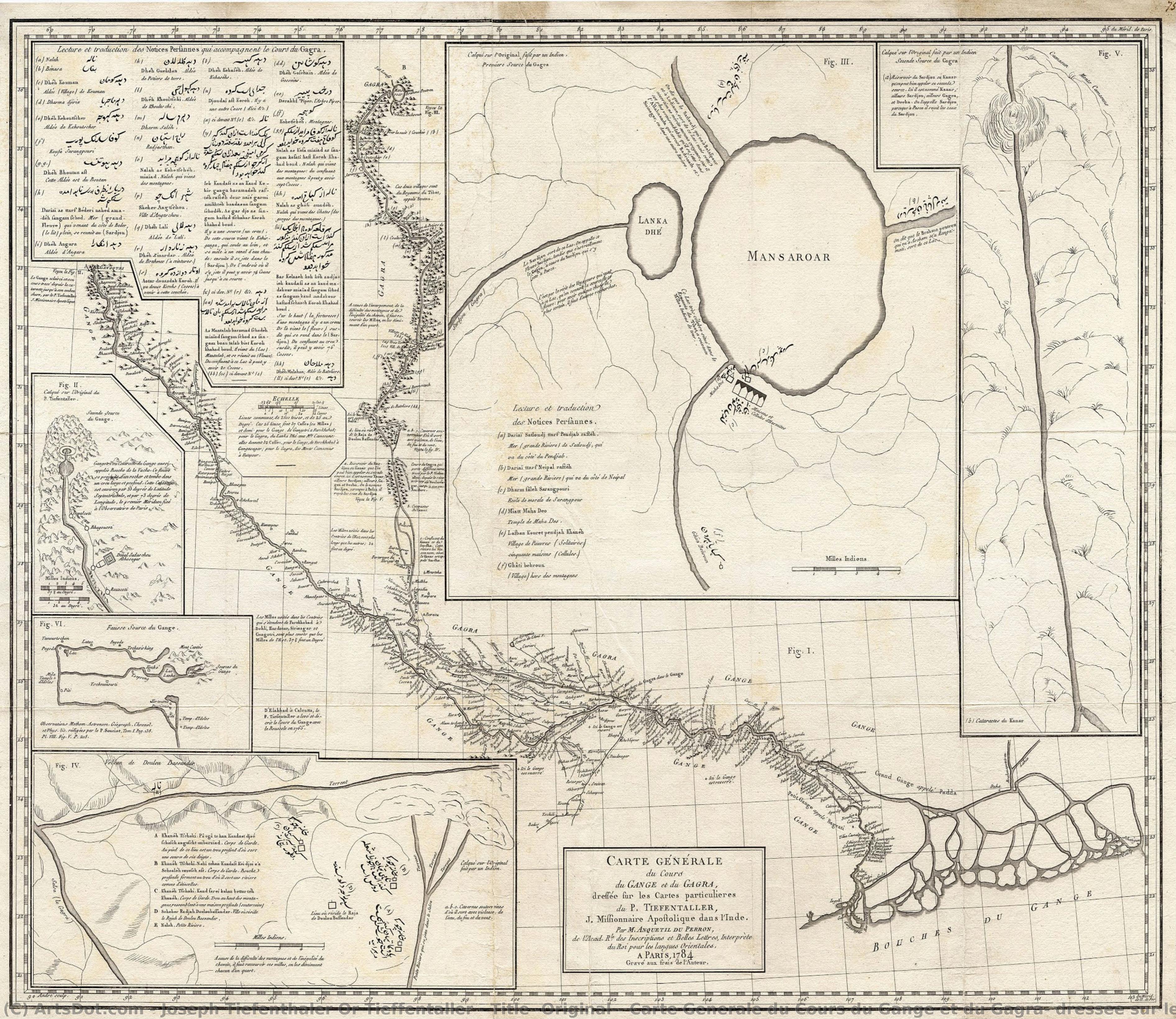
StatsTitle (Original): Carte Generale du Cours du Gange et du Gagra, dressee sur les Cartes particulieres du \nP. Tiefentaller, J. Missionnaire Apostolique dans l
 Engraving
- Enlightenment Cartography
 Early Modern
 61.0 x 76.0 cm
 Kalakriti Archives
 Pročitaj više
Kupite digitalnu sliku visoke rezolucije i poboljšanog kvaliteta, koja je znatno superiornija od onoga što vidite u online prikazu.
Svaka datoteka je pedantno pripremljena od strane naših stručnjaka koristeći napredne alate i profesionalnu ručnu retušu. Osiguravamo da svaka slika ima izuzetnu oštrinu, preciznu reprodukciju boja i fine detalje.
Konačna datoteka se dostavlja putem e-pošte u roku od 72 sata, optimizovana za neposrednu upotrebu u profesionalnim, izdavačkim i štamparskim okruženjima. To je isti kvalitet kojem veruju vrhunski studiji dizajna, izdavači i galerije.
Digitalna slika
Preuzmite datoteku visoke rezolucije za ličnu upotrebu, štampanje i kreativne projekte. ( Switch to Print Kupi ručno naslikanu sliku)
Uključeno uz svaku porudžbinu digitalne slike
Profesionalna digitalna isporuka, zagarantovana
Kada odaberete ArtsDot.com, ne dobijate samo sliku – vi primate profesionalno unapređeno digitalno umetničko delo, izrađeno sa najvećom preciznošću i uz garanciju zadovoljstva. Evo svega što automatski dolazi uz vašu porudžbinu:

Brza dostava putem e-pošte
Vaša digitalna slika visoke rezolucije biće vam poslata putem e-pošte u roku od 72 sata od poručivanja – spremna za trenutnu upotrebu.

Digitalna datoteka unapređena veštačkom inteligencijom
Vaše umetničko delo je profesionalno optimizovano korišćenjem naprednih AI alata i ručne obrade, čime se osiguravaju maksimalni detalji, oštrina i preciznost boja.

Besplatna ponovna isporuka doživotno
Slučajno ste obrisali ili izgubili svoju datoteku? Ne brinite – poslaćemo vam je ponovo u bilo kom trenutku, potpuno besplatno.

Bez troškova uvoza – zauvek
Uživajte u svojim umetničkim delima trenutno, bez carine, dažbina ili troškova dostave – digitalni download je uvek bez poreza.

Garancija vernosti boja
Uz pomoć profesionalnih alata i upravljanja bojama, osiguravamo da vaša digitalna slika što vernije odražava originalne boje.

Garancija zadovoljstva od 100 dana
Ako niste zadovoljni svojom digitalnom slikom, izvršićemo reviziju ili ćemo vam vratiti 100% novca u roku od 100 dana – bez ikakvih pitanja.

100% garancija povrata novca
Niste zadovoljni? Dobijte puni povraćaj novca u roku od 100 dana od prijema digitalne datoteke – bez suvišnih pitanja.

Popusti na velike porudžbine
Kupite 3 slike, uštedite 10% - Kupite 5 slika, uštedite 15% - Kupite 10+ slika, uštedite 20%. Odlično za kreativne projekte, galerije i agencije.
A Cartographic Symphony of East and West
In the grand tapestry of Enlightenment-era exploration, few artifacts capture the profound meeting of disparate worlds as elegantly as this exquisite map of the Ganges and Ghaghara Rivers. This intricate engraving is far more than a mere geographical record; it is a visual dialogue between European scientific rigor and ancient Indian spiritual topography. The composition serves as a bridge across centuries, weaving together the meticulous astronomical measurements of Jesuit missionary Joseph Tieffenthaler with the sacred pilgrimage routes established by Indian cartographers over millennia. As one gazes upon the flowing lines of the great rivers, there is a palpable sense of discovery, an invitation to wander through a landscape that is simultaneously a physical reality and a deeply spiritual realm.
The artistry of this piece lies in its sophisticated layering of information and perspective. The central map, rendered with remarkable precision, showcases the lifeblood of Northern India—the Ganges and Ghaghara (Karnali) rivers—tracing their winding paths through the vast Gangetic Plain down to the bustling port of Calcutta. This primary focus is beautifully complemented by a series of inset maps that act as windows into the mysterious origins of these waters. These smaller vignettes, particularly those depicting the ‘Gomukh’ or Cow’s Mouth at the foot of the Gangotri Glacier and the serene Lake Manasarovar in Tibet, provide a sense of depth and scale that transcends simple navigation. The interplay of French and Persian toponymy across the parchment creates a rich, multilingual texture, reminding the viewer of the Mughal Court's enduring influence amidst the burgeoning era of European scientific inquiry.
The Legacy of the Jesuit Explorer
To understand the soul of this map, one must look to the life of its primary architect, Joseph Tieffenthaler. An Austrian Jesuit missionary born in Italy, Tieffenthal_haler spent over four decades traversing the Indian subcontinent, not merely as a man of faith, but as a dedicated scientist of the earth. Armed with a quadrant and an unyielding curiosity, he transformed his missionary journeys into a monumental feat of cartographic achievement. This work represents the culmination of his life's labor, later assembled by the esteemed French orientalist Abraham-Hyacinthe Antequil du Perron. The map stands as a testament to a period when the pursuit of knowledge was an adventurous, often perilous, endeavor that required a unique blend of cultural empathy and mathematical precision.
For the discerning collector or interior designer, this reproduction offers a profound sense of intellectual prestige and timeless elegance. The monochromatic beauty of the engraving lends itself to a variety of sophisticated decor styles, from the classic grandeur of a traditional library to the curated minimalism of a modern gallery space. It is a piece that invites conversation, acting as a focal point that stimulates thought about history, geography, and the interconnectedness of human civilization. Owning such a work is not merely about possessing an image; it is about preserving a fragment of the Enlightenment spirit—a celebration of the moment when the world began to truly map its own complexity.
Srodna umetnička dela






Biografija umetnika
early life and missionary work
joseph tiefenthaler or tieffentaller, an austrian jesuit missionary, was born on august 27, 1710, in salorno, near bolzano, italy. his life's trajectory would lead him to become one of the earliest european geographers to write about india, leaving an indelible mark on the world of geography and art.artistic contributions
tiefenthaler's most notable work is descriptio indiae, a comprehensive geographical description of india. this opus not only solidified his position as a pioneering geographer but also showcased his artistic prowess, particularly in the realm of cartography.- cartographic innovations: tiefenthaler's work introduced novel cartographic techniques, setting a precedent for future geographers.
- cultural significance: his descriptions of india provided a unique window into the region's cultural and geographical landscape, influencing european perceptions of the subcontinent.
notable artworks and their significance
- carte generale du cours du gange et du gagra, a map showcasing the courses of the sacred ganges and ghaghara rivers, represents a synergy of indian and european sources. (available for reproduction on ArtsDot)
- this piece is an early example of accurate geographical depiction, blending indian pilgrimage mapping with european enlightenment era cartography.
legacy and influence
tiefenthaler's work has been recognized as a foundational element in the development of indian geography. his innovative approach to cartography has influenced numerous artists and geographers, making him a pivotal figure in the history of geography.- influence on future geographers: tiefenthaler's techniques have been adopted by subsequent geographers, ensuring his legacy endures.
- cultural impact: his descriptions of india have contributed to a broader understanding of the region's cultural and geographical significance.
museums and collections featuring tiefenthaler's work
- the museum parrocchiale (verolanuova, italy) - while not exclusively featuring tiefenthaler's work, this museum showcases a collection of artworks from various periods, including those influenced by his cartographic innovations. (view collection on ArtsDot)
- other notable museums featuring geographical and cartographical works can be found on ArtsDot's art database.

Joseph Tiefenthaler
1710 - 1785 , Italy