

 Preview
 Send
Send Share
Share
 Details

 Download
 Similars
 X-Ray
X-Ray Diaporama
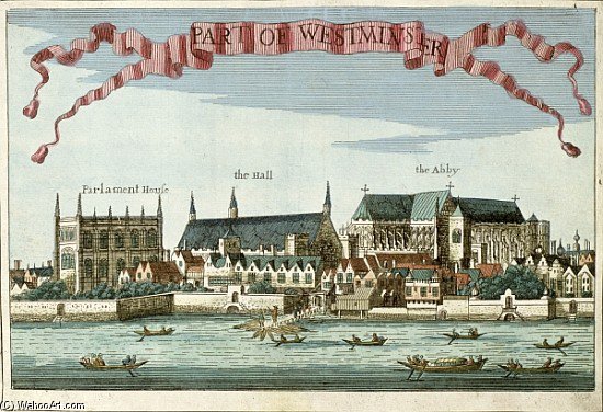
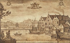
Westminster Showing The Abbey, Hall And Parliament House, From ''a Book Of The Prospects Of The Rema
 Read More
Purchase a high-resolution, enhanced digital image, far superior to the online preview.
Each file is meticulously prepared by our in-house specialists using advanced tools and expert manual retouching. We ensure every image has exceptional clarity, precise color accuracy, and fine detail.
The final file is delivered via email within 72 hours, optimized for immediate use in professional, editorial, and print environments. This is the same quality trusted by top-tier design studios, publishers, and galleries.
Digital Image
Download a high-resolution file for personal display, printing, and creative projects. ( Buy Print Buy Hand Made Painting)
Included in Every Digital Image Order
Expert Digital Delivery, Guaranteed
When you choose ArtsDot.com, you're not just getting an image - you're receiving a professionally enhanced digital artwork, crafted with precision and backed by a satisfaction guarantee. Here's everything that comes with your order, automatically:

Fast Email Delivery
Your high-resolution digital image file will be emailed to you within 72 hours of ordering - ready for immediate use.

AI-Enhanced Digital File
Your artwork is professionally optimized using advanced AI tools and manual editing, ensuring maximum detail, clarity, and color accuracy.

Free Lifetime Re-Delivery
Accidentally deleted or lost your file? No worries - we'll resend it to you anytime, free of charge.

No Import Fees - Ever
Enjoy your artwork instantly with zero customs, duties, or delivery fees - digital downloads are always tax-free.

Color Accuracy Guarantee
We ensure your digital image reflects the original colors as closely as possible using professional tools and color management.

60-Day Satisfaction Guarantee
If you're not satisfied with your digital image, we'll revise it or refund 100% within 60 days - no questions asked.

100% Money-Back Guarantee
Not satisfied? Get a full refund within 60 days of receiving your digital file - no questions asked.

Bulk Order Discounts
Buy 3 images, save 10% - Buy 5, save 15% - Buy 10+, save 20%. Great for creative projects, galleries, and agencies.
Related Artworks
Artist Biography
Robert Morden: Cartographer of a Shifting World
The seventeenth century was an era of profound transformation, marked by burgeoning exploration, shifting political landscapes, and the relentless march of scientific inquiry. Within this dynamic context emerged Robert Morden (c. 1650 – 1703), an English bookseller, publisher, and mapmaker whose meticulous engravings profoundly shaped how England perceived its territories and its place within the wider world. More than simply a cartographer, Morden was a crucial intermediary between the burgeoning scientific community and the public, democratizing access to geographical knowledge in a way unprecedented for his time.
Morden’s early life remains somewhat shrouded in mystery, though he apprenticed under Joseph Moxon, the renowned hydrographer to Charles II. This formative experience instilled within him a deep understanding of mapmaking techniques and a commitment to accuracy – qualities that would define his career. He established his business, “under the sign of the Atlas,” in London’s bustling Cornhill area around 1675, quickly gaining recognition for his detailed and informative maps. Unlike many of his contemporaries who relied on secondhand accounts and embellished descriptions, Morden championed a new approach: gathering information directly from local landowners, gentry, and officials within each county he depicted.
The Counties Come Alive
Morden’s most enduring legacy lies in his series of meticulously rendered county maps. These weren't merely topographical representations; they were vibrant documents that captured the essence of individual regions. Published initially in 1695 as part of a revised edition of William Camden’s *Britannia*, these maps quickly gained popularity and were subsequently reissued multiple times throughout the century. Each map was a testament to Morden's dedication, featuring intricately detailed illustrations of local landmarks – castles, churches, rivers, forests – alongside precise depictions of property boundaries and settlements.
What distinguished Morden’s county maps from their predecessors was their emphasis on local knowledge. He actively sought out firsthand accounts from the people who lived within each county, incorporating their observations into his representations. This approach not only enhanced the accuracy of the maps but also imbued them with a sense of authenticity and immediacy. The cartouches adorning each map – elaborate designs featuring coats of arms and allegorical figures – further elevated their status as works of art and symbols of regional identity.
Beyond England: Maps of Scotland and America
While Morden’s county maps cemented his reputation, he also produced significant cartographic works beyond the borders of England. In 1695, he created a detailed map of Scotland, largely based on the work of Robert Gordon of Straloch, a pioneering Scottish surveyor. This map, though incorporating elements from earlier sources, demonstrated Morden’s ability to synthesize and refine complex geographical information.
Perhaps even more remarkably, Morden produced a series of maps documenting the burgeoning British colonies in North America. These early American maps – some of the earliest ever created – offered invaluable insights into the rapidly expanding colonial territories. They were not simply reproductions of European maps; rather, they reflected Morden’s own research and observations, providing a unique perspective on the challenges and opportunities presented by these new frontiers.
A Legacy in Miniature
Beyond his large-scale county and provincial maps, Morden also produced a series of “Miniature Mordens”—small, highly detailed maps of individual towns and cities. These miniature masterpieces, often sold as playing cards, offered a captivating glimpse into the urban fabric of England’s major settlements. Furthermore, he created intricate world maps in both book form and as decorative atlases, showcasing his mastery of cartographic design and his commitment to disseminating geographical knowledge.
Robert Morden's work represents more than just a collection of maps; it embodies the spirit of exploration, discovery, and intellectual curiosity that defined the seventeenth century. His meticulous attention to detail, his dedication to local knowledge, and his innovative approach to mapmaking left an indelible mark on the history of cartography and continue to fascinate scholars and collectors today.
robert morden
1650 - 1703 , United Kingdom
Quick Facts
- Artistic Movement Or Style: Topographical engraving
- Artists Or Movements Influenced By This Artist: ["Camden's Britannia"]
- Artists Who Influenced This Artist: ['Joseph Moxon']
- Date Of Birth: c. 1650
- Date Of Death: 1703
- Full Name: Robert Morden
- Nationality: British
- Notable Artworks:
- St. Paul's Cathedral
- County maps (1695)
- Map of Scotland (1701)
- Place Of Birth: England

