

jan marcin bansemer and piotr falkenhagen zaleski
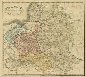
Jan Marcin Bansemer and Piotr Falkenhagen Zaleski: Cartographers of a Lost Homeland The 1837 “Atlas Containing Ten Maps of Poland” stands as more than just a geographical record; it’s a poignant testament to Polish resilience, exile, and the enduring desire for national identity. Created by Jan Marcin Bansemer and Piotr Falkenhagen Zaleski, two Polish refugees deeply embedded within the vibrant community of London, this atlas represents a remarkable synthesis of cartographic skill, historical awareness, and political ambition. Their work wasn’t merely about charting territory; it was an act…
The Subject Atlas
A chart of jan marcin bansemer and piotr falkenhagen zaleski's corpus mapped not by date but by subject. Spokes are what they painted; rings are when; and the threads between stars reveal the patrons and places that secretly connect them.
Spokes — Subject
Each arm of the atlas gathers works by what they depict: portraits, sacred scenes, mythologies, and the scientific studies. Click a spoke to swing that cluster to the top.
Rings — Career Period
Distance from the center marks time. The innermost ring is the earliest period; the outermost, the final years. Style matures as you move outward.
Threads — Shared Context
Coloured lines link works bound by the same patron, commission, or theme. Trace a context to watch related clusters light up across subjects.

