Jan Marcin Bansemer and Piotr Falkenhagen Zaleski: Cartographers of a Lost Homeland
The 1837 “Atlas Containing Ten Maps of Poland” stands as more than just a geographical record; it’s a poignant testament to Polish resilience, exile, and the enduring desire for national identity. Created by Jan Marcin Bansemer and Piotr Falkenhagen Zaleski, two Polish refugees deeply embedded within the vibrant community of London, this atlas represents a remarkable synthesis of cartographic skill, historical awareness, and political ambition. Their work wasn’t merely about charting territory; it was an act of preservation, a deliberate attempt to shape public perception of Poland amidst a period of immense upheaval and partitioning.
Bansemer and Zaleski's story is inextricably linked to the tumultuous events of the late 18th and early 19th centuries. Both men had experienced firsthand the Napoleonic Wars and the subsequent partitions of Poland by Russia, Prussia, and Austria – a process that systematically dismantled the nation’s borders and suppressed its cultural identity. Forced into exile, they found refuge in London, where they established themselves as key figures within the Polish diaspora. This experience profoundly shaped their artistic vision; the atlas wasn't conceived in isolation but rather as a direct response to their displacement and a fervent commitment to safeguarding Poland’s memory.
The Collaborative Creation: A Tapestry of Cartographic Influences
The creation of the atlas was a complex undertaking, involving collaboration with numerous skilled cartographers. Bansemer, a highly experienced mapmaker himself, served as the primary editor and organizer, meticulously overseeing every detail of the project. Zaleski, equally adept at cartography, contributed significantly to the design and execution of several maps. Crucially, they drew upon the expertise of established figures like Auguste-Henri Dufour, renowned for his detailed surveys of France, and Leonard Chodźko, a prominent Polish geographer. This collaborative approach wasn’t simply pragmatic; it reflected a strategic decision to leverage existing talent while simultaneously elevating the project's overall quality and credibility.
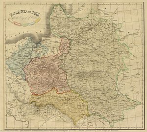
The atlas itself is a remarkable achievement in 19th-century cartography. It meticulously depicts Poland across ten distinct maps, each illustrating a different facet of the country’s political landscape between 1772 – the year of the first partition – and 1831. These aren't merely static representations; they are dynamic visualizations of shifting borders, evolving administrative divisions, and the complex interplay of military campaigns and diplomatic maneuvers. The maps incorporate a wealth of historical detail, including fortifications, roads, rivers, and settlements, all rendered with impressive precision.
A Political Statement: Promoting Polish Identity
Beyond its purely cartographic value, the “Atlas Containing Ten Maps of Poland” functioned as a powerful political statement. Commissioned by Polish émigré organizations in London, it was intended to garner support for the Polish cause among the British public and Parliament. The atlas presented a carefully curated narrative of Polish history – emphasizing resilience, patriotism, and the injustices suffered under foreign rule. By showcasing the country’s rich cultural heritage and strategic importance, Bansemer and Zaleski sought to counter negative stereotypes and advocate for Polish independence.
The inclusion of thematic maps—one illustrating religious divisions and another highlighting linguistic diversity—further underscored the atlas's political message. These elements highlighted the internal complexities of Poland while simultaneously emphasizing its distinct identity as a nation threatened by external aggression. The atlas was distributed widely throughout Britain, reaching influential circles within government and society, and undoubtedly contributed to raising awareness of the Polish plight.
Legacy and Historical Significance
Despite its immediate political goals, the “Atlas Containing Ten Maps of Poland” holds enduring historical significance. It stands as a vital primary source for understanding 19th-century Polish history and the experiences of Polish émigrés in Britain. The atlas’s meticulous cartography, combined with its carefully crafted narrative, offers invaluable insights into the complex dynamics of national identity formation during a period of profound political change.
Furthermore, Bansemer and Zaleski's work exemplifies the crucial role that artists and intellectuals played in preserving cultural memory during times of exile. Their atlas is not just a map; it’s a testament to the enduring spirit of a nation determined to maintain its identity despite facing immense adversity. It remains a poignant reminder of the power of art to shape perceptions, advocate for justice, and safeguard the legacy of a lost homeland.