

 プレビュー
プレビュー
 シェアする
シェアする シェアする
シェアする
 詳細を見る
詳細を見る

 ダウンロード
 似ている作品
 X線調査
X線調査 スライドショー
 統計情報
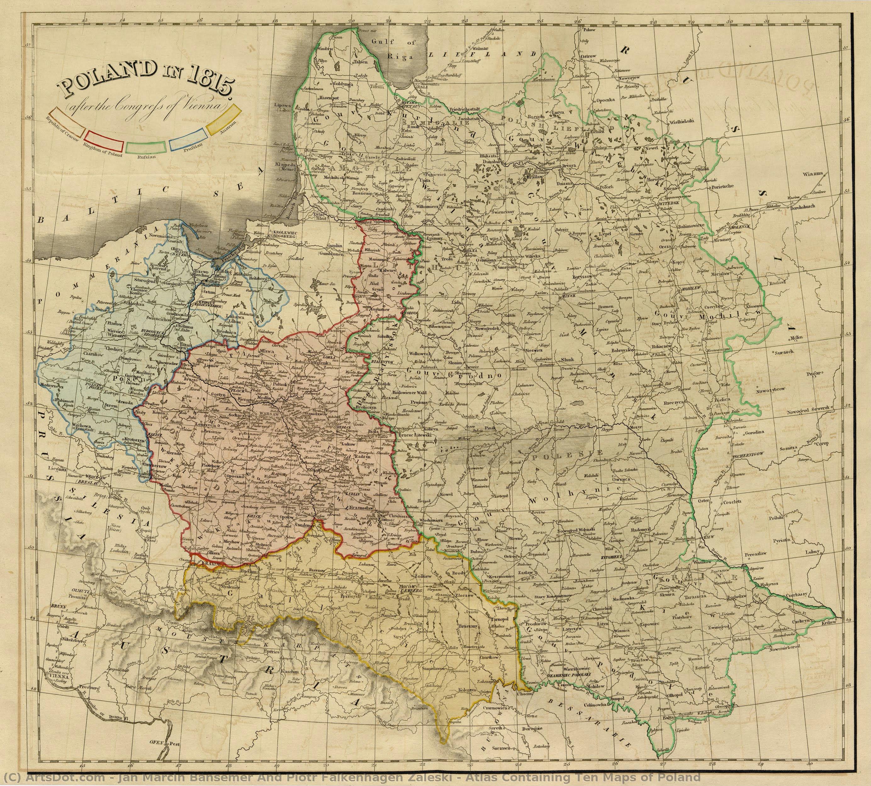
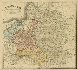
統計情報Atlas Containing Ten Maps of Poland


 詳細を見る
詳細を見る
オンラインプレビューをはるかに凌ぐ、高解像度で鮮明なデジタル画像をご購入いただけます。
各ファイルは、社内の専門家が高度なツールと熟練した手作業によるレタッチを用いて、細心の注意を払って準備されています。すべての画像において、卓越した鮮明度、正確な色彩再現性、そして繊細なディテールを保証いたします。
最終ファイルは、プロフェッショナルな編集・印刷環境ですぐにご利用いただけるよう最適化された状態で、72時間以内にメールにてお届けいたします。これは、一流のデザインスタジオ、出版社、ギャラリーから信頼されているものと同等の品質です。
デジタルアート
個人での鑑賞、印刷、クリエイティブなプロジェクト用に、高解像度ファイルをダウンロードできます。 ( プリント版に切り替え 手描きの絵画を購入)
デジタル画像のご注文に付随する特典
高品質なデジタル画像配信を、確かな品質で。
ArtsDot.com を選ぶことは、単に画像を手に入れることではありません。それは、プロの手によって精密に仕上げられ、満足保証が付いた高品質なデジタルアートワークを受け取ることを意味します。ご注文いただいた際に自動的に付随する内容は、以下の通りです:

メールですぐにお届け
ご注文から72時間以内に、高解像度のデジタル画像ファイルがメールでお手元に届きます。すぐにそのままご利用いただけます。

AI技術で最適化されたデジタルファイル
お客様の作品は、高度なAIツールと専門家による手作業の編集を組み合わせてプロフェッショナルに最適化されており、細部のディテール、鮮明さ、そして正確な色再現性を最大限に引き出しています。

一生涯無料の再送サービス
ファイルを誤って削除したり、紛失してしまったりしましたか?ご安心ください。いつでも無料で再送いたします。

輸入手数料は一切かかりません
関税や手数料、配送料を気にすることなく、お気に入りのアートワークをすぐにお楽しみいただけます。デジタルダウンロードは常に免税です。

色彩再現の保証
プロ仕様のツールとカラーマネジメント技術を用いることで、デジタル画像が元の色を最大限に忠実に再現することを保証いたします。

100日間満足保証
ご購入いただいたデジタル画像にご満足いただけない場合は、100日以内であれば、理由を問わず修正または100%の返金対応をさせていただきます。

100% 返金保証
ご満足いただけない場合は、デジタルファイルを受け取ってから100日以内であれば、理由を問わず全額返金いたします。

まとめ買い割引
3枚購入で10%OFF - 5枚購入で15%OFF - 10枚以上購入で20%OFF。クリエイティブなプロジェクト、ギャラリー、エージェンシーに最適です。
A Cartographic Legacy of Resilience
In the delicate lines of the Atlas Containing Ten Maps of Poland, one finds far more than a mere geographical survey; one discovers a profound act of cultural preservation. Created in 1837 by the skilled hands of Jan Marcin Bansemer and Piotr Falkenhagen Zaleski, this exquisite work serves as a poignant window into a nation struggling to maintain its identity amidst the shadows of partition. As an engraving, the piece possesses a meticulous, intricate texture that invites the eye to wander through its ten distinct sections, each rendered with a precision that speaks to the artists' deep devotion to their homeland. The subtle interplay of colors across the various territories does not merely delineate borders; it breathes life into a landscape that was, at the time, being systematically erased from the political map of Europe.
The technique employed in this atlas reflects the mastery of 19th-century cartographic engraving. Every fine line and shaded region is a testament to the painstaking labor required to transform copper or steel into a narrative of survival. For the discerning collector, the visual complexity of the work offers an unparalleled depth, where the technical brilliance of the etching meets the emotional weight of history. The way light seems to catch the detailed topography creates a sense of movement, making the map feel less like a static document and more like a living, breathing entity. This level of detail makes it an extraordinary centerpiece for those who appreciate art that marries scientific accuracy with profound artistic expression.
Symbolism and the Spirit of Exile
To gaze upon this atlas is to engage with the very soul of Polish resistance. Bansemer and Zaleski, working from the vibrant yet bittersweet community of London, were refugees of a lost era, using their craft to shape public perception and keep the memory of Poland alive in the hearts of the diaspora. Each colored segment of the map acts as a symbolic fragment of a fractured whole, representing a deliberate attempt to reconstruct a national identity that was under siege by the empires of Russia, Prussia, and Austria. The artistry here is inherently political; it is an act of defiance captured in ink and pigment, turning a scholarly tool into a powerful emblem of hope and enduring heritage.
For interior designers and connoisseurs of historical art, this piece offers a unique opportunity to introduce a sense of narrative gravity and intellectual sophistication into a space. Whether displayed in a private library, a formal study, or a curated gallery setting, the Atlas Containing Ten Maps of Poland commands attention through its storied past. It provides a conversation piece that transcends simple decoration, offering instead an invitation to reflect on themes of displacement, memory, and the indomitable human spirit. Owning a high-quality reproduction of this masterpiece allows one to surround themselves with the echoes of history, bringing a timeless elegance and a deep, soulful resonance to any sophisticated interior.
関連作品







作家の略歴
Jan Marcin Bansemer and Piotr Falkenhagen Zaleski: Cartographers of a Lost Homeland
The 1837 “Atlas Containing Ten Maps of Poland” stands as more than just a geographical record; it’s a poignant testament to Polish resilience, exile, and the enduring desire for national identity. Created by Jan Marcin Bansemer and Piotr Falkenhagen Zaleski, two Polish refugees deeply embedded within the vibrant community of London, this atlas represents a remarkable synthesis of cartographic skill, historical awareness, and political ambition. Their work wasn’t merely about charting territory; it was an act of preservation, a deliberate attempt to shape public perception of Poland amidst a period of immense upheaval and partitioning.
Bansemer and Zaleski's story is inextricably linked to the tumultuous events of the late 18th and early 19th centuries. Both men had experienced firsthand the Napoleonic Wars and the subsequent partitions of Poland by Russia, Prussia, and Austria – a process that systematically dismantled the nation’s borders and suppressed its cultural identity. Forced into exile, they found refuge in London, where they established themselves as key figures within the Polish diaspora. This experience profoundly shaped their artistic vision; the atlas wasn't conceived in isolation but rather as a direct response to their displacement and a fervent commitment to safeguarding Poland’s memory.
The Collaborative Creation: A Tapestry of Cartographic Influences
The creation of the atlas was a complex undertaking, involving collaboration with numerous skilled cartographers. Bansemer, a highly experienced mapmaker himself, served as the primary editor and organizer, meticulously overseeing every detail of the project. Zaleski, equally adept at cartography, contributed significantly to the design and execution of several maps. Crucially, they drew upon the expertise of established figures like Auguste-Henri Dufour, renowned for his detailed surveys of France, and Leonard Chodźko, a prominent Polish geographer. This collaborative approach wasn’t simply pragmatic; it reflected a strategic decision to leverage existing talent while simultaneously elevating the project's overall quality and credibility.
The atlas itself is a remarkable achievement in 19th-century cartography. It meticulously depicts Poland across ten distinct maps, each illustrating a different facet of the country’s political landscape between 1772 – the year of the first partition – and 1831. These aren't merely static representations; they are dynamic visualizations of shifting borders, evolving administrative divisions, and the complex interplay of military campaigns and diplomatic maneuvers. The maps incorporate a wealth of historical detail, including fortifications, roads, rivers, and settlements, all rendered with impressive precision.
A Political Statement: Promoting Polish Identity
Beyond its purely cartographic value, the “Atlas Containing Ten Maps of Poland” functioned as a powerful political statement. Commissioned by Polish émigré organizations in London, it was intended to garner support for the Polish cause among the British public and Parliament. The atlas presented a carefully curated narrative of Polish history – emphasizing resilience, patriotism, and the injustices suffered under foreign rule. By showcasing the country’s rich cultural heritage and strategic importance, Bansemer and Zaleski sought to counter negative stereotypes and advocate for Polish independence.
The inclusion of thematic maps—one illustrating religious divisions and another highlighting linguistic diversity—further underscored the atlas's political message. These elements highlighted the internal complexities of Poland while simultaneously emphasizing its distinct identity as a nation threatened by external aggression. The atlas was distributed widely throughout Britain, reaching influential circles within government and society, and undoubtedly contributed to raising awareness of the Polish plight.
Legacy and Historical Significance
Despite its immediate political goals, the “Atlas Containing Ten Maps of Poland” holds enduring historical significance. It stands as a vital primary source for understanding 19th-century Polish history and the experiences of Polish émigrés in Britain. The atlas’s meticulous cartography, combined with its carefully crafted narrative, offers invaluable insights into the complex dynamics of national identity formation during a period of profound political change.
Furthermore, Bansemer and Zaleski's work exemplifies the crucial role that artists and intellectuals played in preserving cultural memory during times of exile. Their atlas is not just a map; it’s a testament to the enduring spirit of a nation determined to maintain its identity despite facing immense adversity. It remains a poignant reminder of the power of art to shape perceptions, advocate for justice, and safeguard the legacy of a lost homeland.
プロフィール概要
- Artistic Movement Or Style: Cartography
- Artists Who Influenced This Artist:
- Auguste-Henri Dufour
- Leonard Chodźko
- Full Name: Jan Marcin Bansemer & Piotr Falkenhagen Zaleski
- Nationality: Polish
- Notable Artworks: ['Atlas Containing Ten Maps of Poland']
- Place Of Birth: Poland