

 Pregledaj u prostoru
 Pošalji
 Podeli
 Detalji o delu

 Преузми
 Slični predmeti
 Rendgenski snimak
 Slajdovi
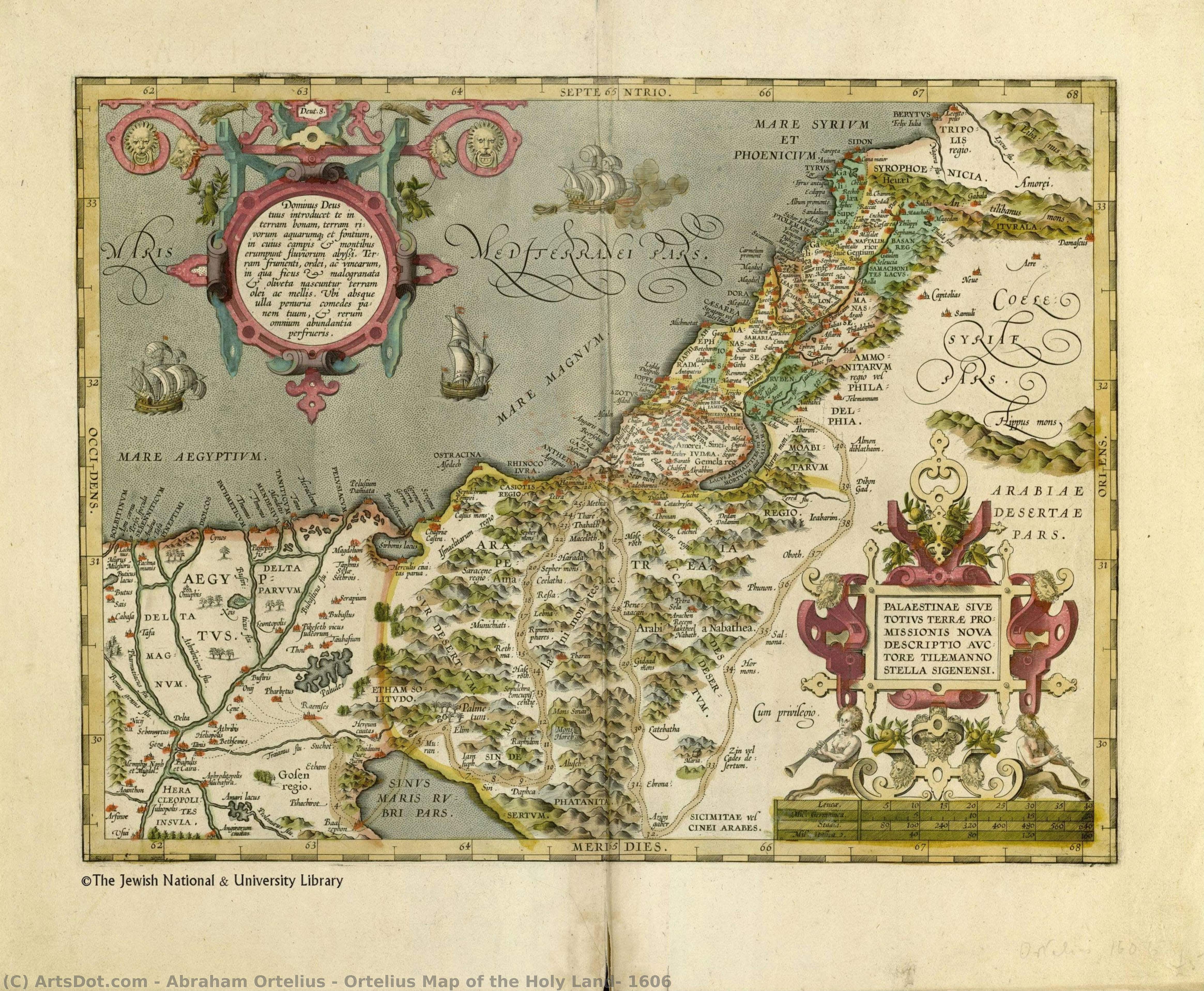
Ortelius Map of the Holy Land, 1606
 Painting
- Renaissance Cartography
 1606
1606- Early Modern
 34.0 x 45.0 cm
 Nacionalna biblioteka Izraela
 Pročitaj više
Ručno rađena uljana reprodukcija
Ručno oslikano uljanim bojama na platnu u dimenzijama i okviru po vašem izboru, izrađeno po porudžbini od strane naših umetnika. ( Kupi print Kupi digitalnu sliku)




































Izaberite jednu od naših unapred definisanih veličina koje odgovaraju originalnim proporcijama umetničkog dela.

Можете унети сопствене димензије како бисте прилагодили дело одређеном оквиру или простору. Ако одабрана величина не одговара пропорцијама оригинала, слика ће бити исечена или проширена додатним елементима који се ручно насликавају. Дигитални prikaz ће вам бити послат на одобрење пре почетка производње.
Имајте на уму да преглед на екрану не одражава стварно исецање или проширење. Само приказ (mockup) ће тачно приказати коначну композицију.
Иако су доступне прилагођене величине, препоручујемо да одаберете димензију из дефинисане листе како бисте сачували оригиналне пропорције.
Nakon narudžbine, tim ArtsDot.com će klijentu putem e-pošte poslati uputstva i dostaviti prikaz predloženog rešenja
Isporuka širom sveta () za 3/4 nedelje umesto uobičajenih 5 nedelja. (23 август). Bez kompromisa po pitanju kvaliteta.

Besplatna ekspresna dostava širom sveta

Visokokvalitetno laneno platno

Kompletno osiguranje transporta

Garancija povraćaja carine i uvoznih dažbina

Garancija vernosti boja

Politika povrata u roku od 60 dana (samo u slučaju nedostataka)

Garancija povrata novca od 100%

Popust pri grupnoj kupovini
 Opcija sa staklom dostupna je samo za dimenzije manje od 110 cm

Ortelius Map of the Holy Land, 1606
Tehnika reprodukcije
Dimenzije reprodukcije
-


Konačna cena
$ 263
Opis umetničkog dela
A Journey Through Time: The Cartographic Splendor of the Holy Land
To gaze upon the Ortelius Map of the Holy Land, 1606, is to embark on a voyage not merely across geography, but through the very fabric of history. This exquisite reproduction captures the essence of early seventeenth-century cartography, a period when maps were far more than navigational tools; they were profound works of art that blended scientific inquiry with imaginative storytelling. The scene unfolds as a rich tapestry of the Levant, where the rugged topography of mountains and valleys serves as a stage for a bustling, miniature world. Every stroke of the brush evokes the meticulous detail of Abraham Ortelius’s original vision, inviting the viewer to wander through a landscape where the boundaries between reality and myth feel beautifully blurred.
The composition is a masterclass in visual narrative, teeming with life that breathes vitality into the ancient terrain. Scattered across the azure waters are majestic ships, their sails caught in an invisible breeze, suggesting the era's great maritime explorations. On the verdant shores, the presence of exotic fauna—most notably a striking elephant positioned on the far right—adds an element of wonder and the allure of the unknown. These details, accompanied by soaring birds and tiny, industrious figures, transform the map from a static document into a living ecosystem. For the discerning collector, this piece offers a window into a world where every landmark tells a story of pilgrimage, trade, and discovery.
Technically, this hand-painted reproduction honors the intricate engraving style that defined the Golden Age of Flemish cartography. The artist captures the delicate linework and the subtle, aged patina of the original 1606 print, ensuring that the textures of the parchment and the depth of the mountain ranges feel authentic. The interplay of light and shadow across the valleys creates a sense of three-dimensional relief, making the landscape appear to rise from the canvas. This level of craftsmanship is essential for those seeking to bring a sense of intellectual depth and historical prestige to a curated space.
For interior designers and art enthusiasts alike, this map serves as a sophisticated focal point that transcends simple decoration. It possesses an emotional resonance that evokes nostalgia for the Age of Discovery, making it an ideal centerpiece for a library, a study, or a grand hallway. Whether paired with classical furniture to enhance a traditional aesthetic or set against modern, minimalist decor to provide a storied contrast, the Ortelius Map commands attention. It is more than a reproduction; it is an invitation to contemplate our shared human history and the enduring beauty of the world as seen through the eyes of the masters.
Srodna umetnička dela





Biografija umetnika
Abraham Ortelius: Pioneer of Modern Cartography
Abraham Ortelius (1527-1598) stands as a monumental figure in the history of mapmaking and scientific exploration, largely unrecognized until recent decades. Born in Antwerp, Belgium—a vibrant hub of Renaissance scholarship and artistic innovation—Ortelius’s life was marked by intellectual curiosity and unwavering dedication to advancing geographical knowledge. Trained initially as an engraver, he swiftly transitioned into publishing, establishing a workshop that would become synonymous with the production of groundbreaking atlases and meticulously crafted maps. His ambition wasn't merely decorative; it was driven by a profound belief in the power of accurate representation to illuminate understanding of the world.- Early Life & Training: Ortelius’s formative years were steeped in humanist ideals, fostering an appreciation for classical learning and observation. He honed his engraving skills under Rubens, absorbing techniques that would prove invaluable in reproducing his maps with exceptional detail.
- Theatrum Orbis Terrarum (1570): Ortelius's magnum opus, *Theatrum Orbis Terrarum*, represents a pivotal moment in cartographic history. Published during the tumultuous Reformation era, it was the first atlas to employ copperplate engraving on a grand scale—a revolutionary method that allowed for unprecedented precision and artistic beauty. It meticulously charted Europe, Asia, Africa, and the Americas, incorporating Ptolemy’s geocentric model alongside observations from explorers like Magellan and Drake.
- Influence & Collaborations: Ortelius didn't operate in isolation; he actively engaged with fellow scholars and artists. Notably, his collaboration with Ludovico Teixeira—a Portuguese cartographer—resulted in the creation of a comprehensive atlas of Brazil, significantly bolstering Portugal’s maritime empire and establishing a benchmark for future Brazilian mapping endeavors.
- Legacy & Significance: Ortelius's impact extends far beyond the production of atlases. His meticulous research into ancient texts and his insistence on incorporating new scientific data fundamentally reshaped how Europeans perceived their surroundings. *Theatrum Orbis Terrarum* served as a cornerstone for subsequent generations of cartographers, influencing exploration, navigation, and ultimately contributing to the dissemination of knowledge about the globe.
A Detailed Examination of Ortelius’s Cartographic Technique
Ortelius's maps weren’t simply copied from existing sources; they were painstakingly reconstructed using a combination of Ptolemaic calculations, astronomical observations, and firsthand accounts from explorers. The engravers employed by Ortelius utilized techniques perfected during the Renaissance—particularly hatching and cross-hatching—to convey tonal variations in terrain elevation with remarkable accuracy. Color printing was also experimented with, albeit sparingly, adding visual richness to certain sections of the atlas. These innovations underscored Ortelius’s commitment to presenting a scientifically informed depiction of the Earth.Notable Works Beyond Theatrum Orbis Terrarum
While *Theatrum Orbis Terrarum* cemented Ortelius's reputation as a visionary, he produced numerous other maps and atlases that showcased his exceptional skill and dedication to geographical accuracy. These included detailed charts of the Mediterranean Sea, explorations of Scandinavia, and depictions of Persia—reflecting Ortelius’s broad interests in maritime navigation and scholarly pursuits. His meticulous attention to detail ensured that these works remained invaluable resources for navigators and scholars alike.Ortelius's Portrait by Rubens: A Reflection of Renaissance Idealism
Sir Peter Paul Rubens commissioned a portrait of Abraham Ortelius, capturing him amidst his workshop—a scene replete with maps, instruments, and scholarly texts. The painting exemplifies the humanist ideals prevalent during the Renaissance, portraying Ortelius as an intellectual figure engaged in serious contemplation. Rubens skillfully rendered Ortelius’s face with subtle shading and anatomical precision, reflecting the artistic standards of the era and solidifying Ortelius's place within the cultural landscape of Antwerp.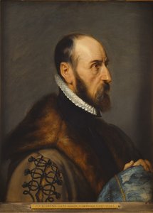
Abraham Ortelius
1527 - 1598 , Belgium
Osnovne informacije
- Artistic Movement Or Style: Renaissance cartography
- Artists Or Movements Influenced By This Artist: ['Cartography']
- Artists Who Influenced This Artist: ['Johannes Mercator']
- Date Of Birth: 1527 Antwerp, Belgium
- Date Of Death: 1598
- Full Name: Abraham Ortelius
- Nationality: Flemish
- Notable Artworks: ['Theatrum Orbis Terrarum']
- Place Of Birth: Antwerp
Povezani članci
Echoes of Time: Nostalgia, Technique & Cultural Significance in Vintage Paintings
Explore the captivating world of vintage paintings! Discover key styles, cultural significance & collecting tips from art experts at ArtsDot. Find authentic reproductions and elevate your home décor.
Echoes of Time: Exploring the Enduring Appeal of Vintage Artwork
Explore the captivating world of vintage art! Discover its history, enduring appeal, & how to build your own collection. Expert advice, custom reproductions & museum-quality prints at ArtsDot.
Echoes of Time: Exploring the Enduring Appeal & Historical Context of Vintage Art Prints
Explore the captivating world of vintage art prints! Discover their history, collecting tips & enduring appeal. Expert insights on chromolithography and building a legacy collection with ArtsDot.
Echoes of Eras Past: Exploring Themes & Techniques in Vintage Art Collections
Explore the captivating world of vintage art! Discover historical movements, iconic themes & collecting tips. Find handmade reproductions & expert appraisal at ArtsDot.
Abraham Hulk Senior: Pioneering Maritime Topography of the Dutch Golden Age
Explore the captivating seascapes of Abraham Hulk Senior, a leading Anglo-Dutch marine painter of the 19th century. Discover his signature style, family legacy & collectable artworks at ArtsDot.

