

 Pregledaj u prostoru
 Pošalji
 Podeli
 Detalji o delu

 Преузми
 Slični predmeti
 Rendgenski snimak
 Slajdovi
 Statistika
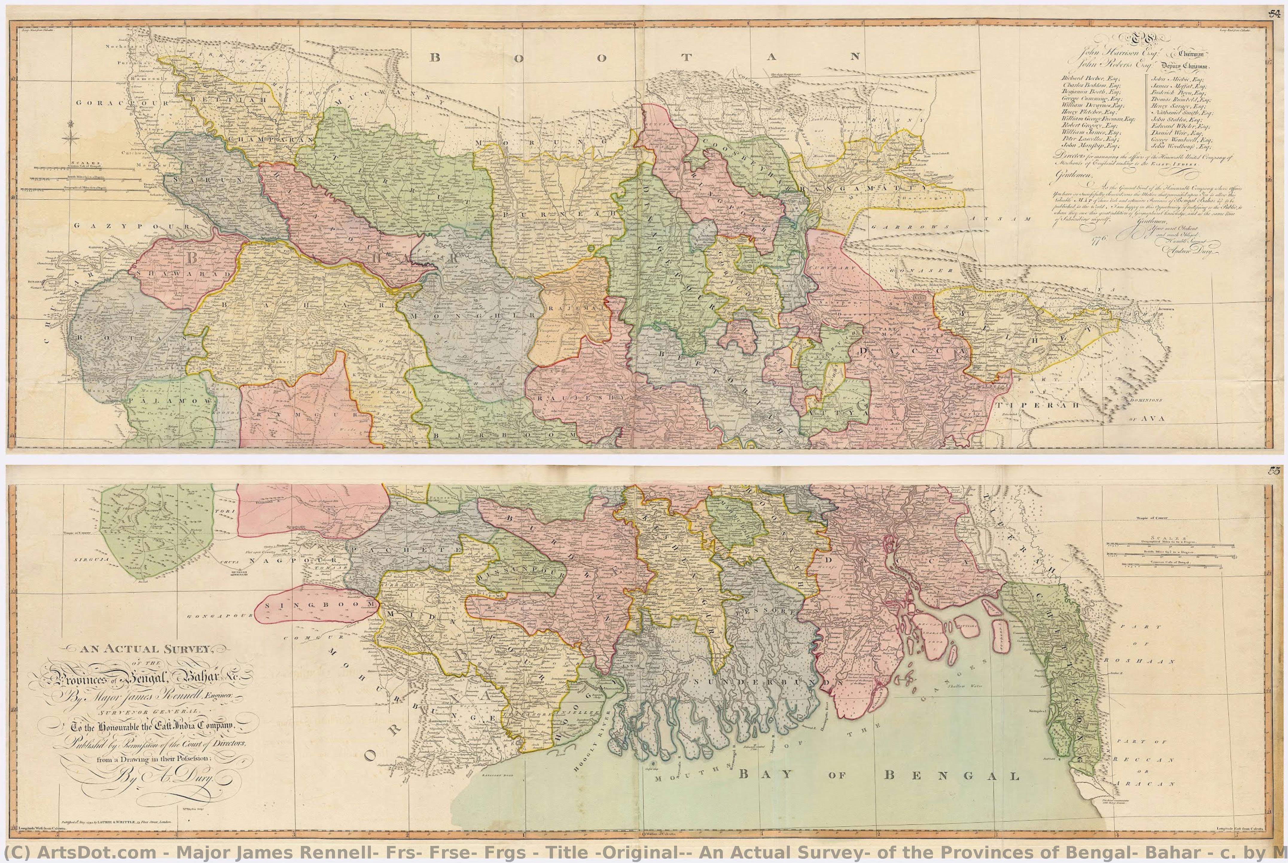
Title (Original): An Actual Survey, of the Provinces of Bengal, Bahar & c. by Major James Rennell Esq. Engineer to the Honorable the East India Company. Published by Permission of the Court of Directors from a Drawing in their Possession by A. Dury.
 Wash
Wash Early Modern
 108.0 x 151.0 cm
 Kalakriti Archives
 Pročitaj više
Kupite digitalnu sliku visoke rezolucije i poboljšanog kvaliteta, koja je znatno superiornija od onoga što vidite u online prikazu.
Svaka datoteka je pedantno pripremljena od strane naših stručnjaka koristeći napredne alate i profesionalnu ručnu retušu. Osiguravamo da svaka slika ima izuzetnu oštrinu, preciznu reprodukciju boja i fine detalje.
Konačna datoteka se dostavlja putem e-pošte u roku od 72 sata, optimizovana za neposrednu upotrebu u profesionalnim, izdavačkim i štamparskim okruženjima. To je isti kvalitet kojem veruju vrhunski studiji dizajna, izdavači i galerije.
Digitalna slika
Preuzmite datoteku visoke rezolucije za ličnu upotrebu, štampanje i kreativne projekte. ( Pređi na štampu Kupi ručno naslikanu sliku)
Uključeno uz svaku porudžbinu digitalne slike
Profesionalna digitalna isporuka, zagarantovana
Kada odaberete ArtsDot.com, ne dobijate samo sliku – vi primate profesionalno unapređeno digitalno umetničko delo, izrađeno sa najvećom preciznošću i uz garanciju zadovoljstva. Evo svega što automatski dolazi uz vašu porudžbinu:

Brza dostava putem e-pošte
Vaša digitalna slika visoke rezolucije biće vam poslata putem e-pošte u roku od 72 sata od poručivanja – spremna za trenutnu upotrebu.

Digitalna datoteka unapređena veštačkom inteligencijom
Vaše umetničko delo je profesionalno optimizovano korišćenjem naprednih AI alata i ručne obrade, čime se osiguravaju maksimalni detalji, oštrina i preciznost boja.

Besplatna ponovna isporuka doživotno
Slučajno ste obrisali ili izgubili svoju datoteku? Ne brinite – poslaćemo vam je ponovo u bilo kom trenutku, potpuno besplatno.

Bez troškova uvoza – zauvek
Uživajte u svojim umetničkim delima trenutno, bez carine, dažbina ili troškova dostave – digitalni download je uvek bez poreza.

Garancija vernosti boja
Uz pomoć profesionalnih alata i upravljanja bojama, osiguravamo da vaša digitalna slika što vernije odražava originalne boje.

Garancija zadovoljstva od 100 dana
Ako niste zadovoljni svojom digitalnom slikom, izvršićemo reviziju ili ćemo vam vratiti 100% novca u roku od 100 dana – bez ikakvih pitanja.

100% garancija povrata novca
Niste zadovoljni? Dobijte puni povraćaj novca u roku od 100 dana od prijema digitalne datoteke – bez suvišnih pitanja.

Popusti na velike porudžbine
Kupite 3 slike, uštedite 10% - Kupite 5 slika, uštedite 15% - Kupite 10+ slika, uštedite 20%. Odlično za kreativne projekte, galerije i agencije.
A Cartographic Masterpiece: The Vision of Bengal
In the annals of geographical discovery, few works command as much reverence as Major James Rennell’s 1783 survey, An Actual Survey, of the Provinces of Bengal, Bahar & c. This breathtaking piece is far more than a mere navigational tool; it is a profound intersection of scientific precision and imperial ambition. As one gazes upon this reproduction, one is immediately transported to the late 18th century, an era defined by the expansion of the East India Company and the meticulous documentation of the unknown. The map serves as a window into a world being systematically measured, categorized, and brought under the gaze of the British Crown, making it a captivating centerpiece for any collector of historical or colonial-era art.
The artistry of the piece lies in its incredible technical detail and the delicate use of original wash colors. Each subha, or district, is distinguished by soft, hand-painted hues that breathe life into the terrain, allowing the viewer to trace the intricate veins of rivers, the dense networks of swamps, and the vital arteries of trade roads. The composition is a masterclass in balance; while the vastness of the Ganges and Nerbudla river systems dominates the visual field, the deliberate vagueness applied to the distant Himalayan ranges reflects the true spirit of 18th-century empiricism—a commitment to recording only what could be scientifically verified. For the interior designer, this map offers a sophisticated texture, blending the organic flow of natural geography with the structured elegance of classical cartography.
The Symbolism of Power and Discovery
Beyond its topographical accuracy, the work carries a heavy symbolic weight, acting as a silent witness to the foundation of the ‘Company Raj.’ Every meticulously labeled village and every delineated path represents the encroaching influence of the East India Company. The map was envisioned by Warren Hastings not merely for military strategy, but as a "Doomsday Book" for Bengal—a tool for taxation, property registration, and social oversight. This layer of historical gravity adds an intellectual depth to the artwork, making it a conversation piece that invites contemplation on how knowledge and mapping have historically been used as instruments of governance.
The presence of subtle decorative elements, such as the dedication by publisher Andrew Dury and the occasional inclusion of period-specific motifs, lends the work a sense of narrative depth. It captures a moment in time when the boundaries of the known world were being redrawn through the sweat and science of pioneers like Rennell. For those seeking to adorn a study, library, or grand hall, this reproduction offers an evocative emotional impact, evoking a sense of nostalgia for the Age of Discovery and a profound respect for the meticulous craftsmanship that defined an era of global transformation.
Srodna umetnička dela






Biografija umetnika
**early life and contributions to geography**
major james rennell, frs, frse, frgs, a prominent figure in the realm of geography and oceanography, was born on december 3, 1742, in the united kingdom. his work not only bridged the gap between these two disciplines but also set the foundation for modern geographical studies. * **pioneering oceanography**: rennell is often referred to as the “father of oceanography”, a testament to his groundbreaking contributions to the field. * **accurate maps of bengal and india**: his detailed maps, produced at a scale of one inch to five miles, remain some of the most accurate geographical representations of his time.**notable artworks and their significance**
while rennell's primary focus was on geography and oceanography, his influence can also be seen in the artistic community. though not a painter himself, his work has inspired numerous artists who have captured the essence of geographical discovery through their art. * walter westley russell’s artwork, "bertram sidney thomas (1892–1950), explorer and arabist", is a notable example. this piece not only reflects the spirit of exploration but also pays homage to rennell's legacy. * the faculty of asian and middle eastern studies in cambridge, united kingdom, houses an impressive collection that includes artworks inspired by rennell’s contributions to geography.**legacy and impact on modern geography**
* **founding member of the royal geographical society**: in 1830, rennell was one of the founders of this prestigious institution in london. * **influence on contemporary art and geography**: his work continues to inspire both artists and geographers, demonstrating the enduring impact of his contributions.- for more information on major james rennell, frs, frse, frgs, visit https://ArtsDot.com/@/major-james-rennell-frs-frse-frgs
- explore the faculty of asian and middle eastern studies collection at /en/art/show/art-d3bnn9-en/
- discover the tate modern, a hub for modern and contemporary art, at https://ArtsDot.com/@@/a@d3bb9k-tate-modern:-o-museu-de-arte-contemporanea-na-gra-bretanha
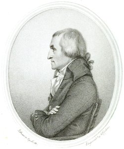
major james rennell, frs, frse, frgs
1742 - 1830 , United Kingdom
Kratke činjenice
- Artists Or Movements Influenced By This Artist: ['Faculty of Asian and Middle Eastern Studies']
- Artists Who Influenced This Artist: ['Walter Westley Russell']
- Date Of Birth: December 3, 1742
- Date Of Death: March 29, 1830
- Full Name: James Rennell
- Nationality: British
- Notable Artworks:
- A Bengal Atlas
- Map of the Provinces of Delhi
- Place Of Birth: Chidley, United Kingdom