

 Pregledaj u prostoru
 Pošalji
 Podeli
 Detalji o delu

 Преузми
 Slični predmeti
 Rendgenski snimak
 Slajdovi
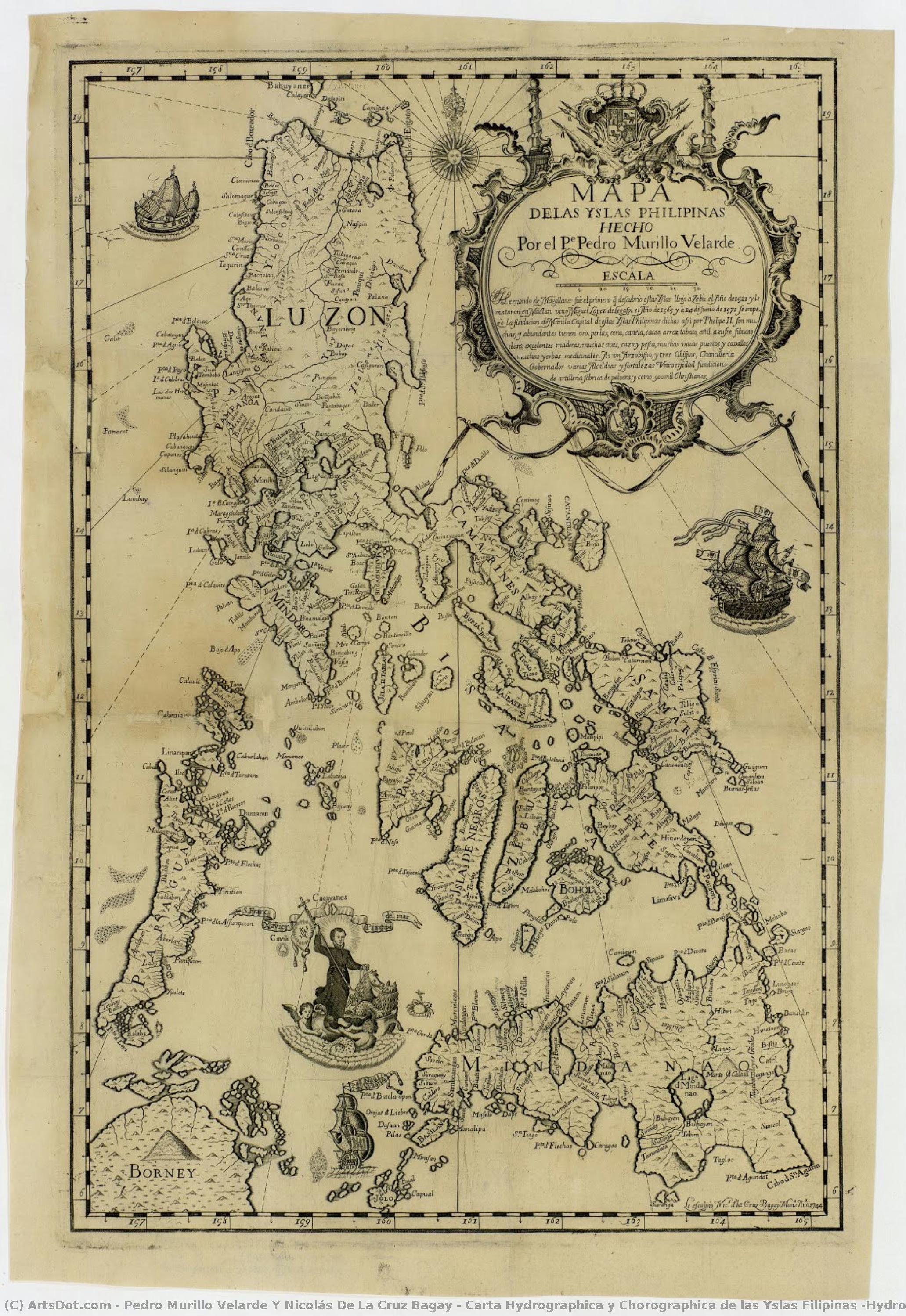
Carta Hydrographica y Chorographica de las Yslas Filipinas (Hydrographic and Chorographic Map of the Philippines)


 Pročitaj više
Giclee štampa / Umetnički otisak
Giclée štampa ili print na platnu muzejskog kvaliteta uz brzu proizvodnju i fleksibilne opcije završne obrade. ( Kupi ručno naslikanu sliku Kupi digitalnu sliku)




P118B $10

P118H $10

P118W $10

P438Z $10

P508JH $12

P508YH $12

P805H $10

P805Z $10

P919BZ $10

P919G $10

P919XJ $10

P959ZH $10

P968JZ $12

W106C $8

W218G $10

W218JH $8

W218Y $10

W307PJ $10

W316G $10

W316PJ $8

W316Y $10

W398PJ $8

W4111J $10

W500HY $15

W500JH $15

W692G $12

W849H $8

W940BG $15

W953PJ $8




Izaberite jednu od naših unapred definisanih veličina koje odgovaraju originalnim proporcijama umetničkog dela.

Možete uneti sopstvene dimenzije kako biste umetničko delo prilagodili specifičnom okviru ili prostoru. Ako odabrani format ne odgovara proporcijama originalne slike, mi ćemo ili iscrtati deo dela ili proširiti sliku pomoću ogledane ivice ili jednobojnog popunjavanja. Digitalni prikaz će vam biti poslat na odobrenje pre početka proizvodnje.
Imajte na umu da pregled na ekranu ne odražava stvarno iscrtavanje ili proširivanje. Samo će prikaz (mockup) precizno pokazati finalnu kompoziciju.
Iako su prilagođene dimenzije dostupne, preporučujemo da odaberete dimenziju sa unapred definisane liste kako biste očuvali originalne proporcije.
Dostava širom sveta () za 2 nedelje umesto uobičajenih 4/5 nedelja. (2 септембар)

Besplatna ekspresna dostava širom sveta

Visokokvalitetno laneno platno

Kompletno osiguranje transporta

Garancija povraćaja carine i uvoznih dažbina

Garancija vernosti boja

Politika povrata u roku od 60 dana (samo u slučaju nedostataka)

Garancija povrata novca od 100%

Popust pri grupnoj kupovini
 Opcija sa staklom dostupna je samo za dimenzije manje od 110 cm

Carta Hydrographica y Chorographica de las Yslas Filipinas (Hydrographic and Chorographic Map of the Philippines)
Giclee štampa / Umetnički otisak
Dimenzije reprodukcije
-


Konačna cena
$ 62
Srodna umetnička dela








Biografija umetnika
The Architect of the Archipelago: The Legacy of Pedro Murillo Velarde
In the golden age of Spanish maritime exploration, few names resonate with as much scientific and cultural weight as Pedro Murillo Velarde. A man whose life was defined by the intersection of faith, mathematics, and discovery, Velarde was far more than a mere cartographer; he was a visionary who sought to capture the very soul of the Philippine archipelago through the precision of science. Born in Madrid, Spain, his early years were steeped in the rigorous intellectual traditions of Jesuit education. At Loyola College Madrid, he honed his mastery over the celestial and the terrestrial, developing an exceptional aptitude for astronomy and geometric calculations. This profound scientific foundation would later serve as the compass for his most enduring contribution to human knowledge.
The trajectory of Velarde’s life shifted irrevocably in 1726 when he accepted a prestigious mission from the Jesuit Order to relocate to Manila. Tasked with establishing a new observatory in the Spanish East Indies, Velarde brought with him an unwavering dedication to empirical observation. His arrival in the Philippines marked the beginning of a transformative era where European scientific methodology met the rich, complex realities of the Pacific. This period of his life was not merely about mapping coastlines; it was about translating the vast, intricate geography of a burgeoning colonial frontier into a language that the rest of the world could comprehend.
A Symphony of Collaboration and Craft
The true brilliance of Velarde’s work lies in its profound collaborative nature, representing a rare and beautiful union between European scholarship and indigenous artistry. While Velarde provided the mathematical rigor and hydrographic data gathered from arduous Jesuit expeditions, he recognized that such a monumental undertaking required a master's touch in physical form. This led to his historic partnership with Nicolás de la Cruz Bagay, an artisan of extraordinary talent from Pangasinan. As an engraver of unparalleled skill, Bagay possessed the ability to translate complex topographical surveys onto copper plates with breathtaking clarity.
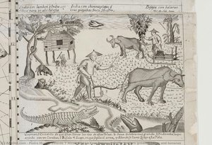
Together, they breathed life into the Carta Hydrographica y Chorographica de las Islas Filipinas. This was not a solitary achievement but a multidisciplinary masterpiece that also drew upon the artistic vision of Francisco Suárez. The resulting work was a tapestry of information, where scientific accuracy met aesthetic splendor. Through their combined efforts, the map became more than a navigational tool; it became a narrative medium. It depicted not only the intricate web of rivers, harbors, and islands but also the human element of the archipelago, illustrating various ethnic groups and the vibrant life that pulsed through the Spanish East Indies.
The Mother of All Philippine Maps
Completed in 1734, the Velarde Map has earned its venerable title as the "Mother of all Philippine Maps." Its historical significance cannot be overstated, as it stands as the first and most important scientific chart of the Philippines ever produced. The map’s intricate detail—capturing maritime routes from Manila to Spain and New Spain—provided a vital lifeline for colonial commerce and naval strategy. It was a document of immense political power, dedicated to the King of Spain, yet it possessed an ethnographic depth that captured the diverse identities of the islands, from the Sangley to the various indigenous tribes.
The map’s journey through history is as dramatic as its creation. During the British occupation of Manila in the late 18th century, the very copper plates used to print this masterpiece were seized and transported to England. This displacement led to a proliferation of copies across Europe, turning the Velarde Map into a celebrated antiquity that commanded high prices among collectors. Today, we look upon the work of Pedro Murillo Velarde not just as a relic of colonial cartography, but as a monumental achievement of human intellect—a moment in time when science and art converged to define the identity of an entire nation.
Osnovne informacije
- Artistic Movement Or Style: Jesuit Cartography
- Artists Or Movements Influenced By This Artist: ['Cartography']
- Artists Who Influenced This Artist: ['Juan Ruiz Zafra']
- Date Of Birth: Living
- Full Name: Pedro Murillo Velarde y Nicolás de la Cruz Bagay
- Nationality: Spanish
- Notable Artworks: ['Carta Hydrographica y Chorographica de las Islas Filipinas']
- Place Of Birth: Spain
Povezani članci
Giclée Prints: Archival Quality & Aesthetic Nuances for the Discerning Collector
Explore the world of giclée prints with ArtsDot. Learn about archival quality, aesthetic nuances & investment potential. Expert guidance for discerning art collectors seeking museum-quality reproductions and lasting value.
Echoes of Time: Exploring the Enduring Appeal & Historical Context of Vintage Art Prints
Explore the captivating world of vintage art prints! Discover their history, collecting tips & enduring appeal. Expert insights on chromolithography and building a legacy collection with ArtsDot.
The Enduring Legacy of Fine Art Prints: Technique, History & Aesthetic Impact
Explore the rich history & techniques of fine art prints. Discover investment potential, assess authenticity, and learn how to preserve your collection with expert guidance. Trusted insights for discerning collectors.
The Enduring Legacy of Printmaking: Techniques, Themes & Artistic Innovation Across Centuries
Explore the rich history of printmaking with ArtsDot. Discover techniques from intaglio to lithography, learn about collecting valuable prints & find museum-quality reproductions. Expert insights for art enthusiasts and collectors.
The Enduring Legacy of Woodblock Printmaking: Technique, History & Artistic Expression
Explore the rich history of woodblock printmaking – from ancient techniques to Ukiyo-e masterpieces. Discover expert insights on collecting, preserving & appreciating this enduring art form.

