

 Preview
 Send
Send Share
Share
 Details

 Download
 Similars
 X-Ray
X-Ray Diaporama
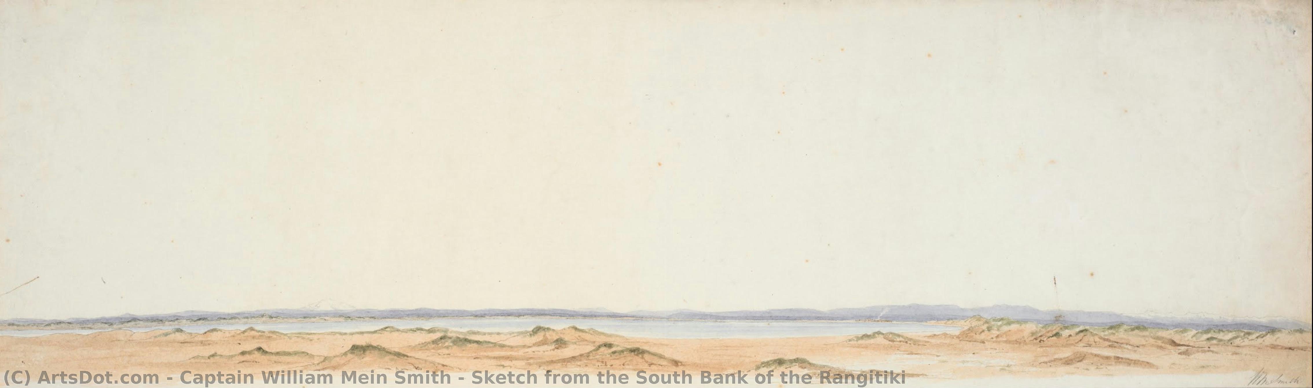
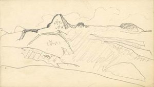
Sketch from the South Bank of the Rangitiki


 Read More
Purchase a high-resolution, enhanced digital image, far superior to the online preview.
Each file is meticulously prepared by our in-house specialists using advanced tools and expert manual retouching. We ensure every image has exceptional clarity, precise color accuracy, and fine detail.
The final file is delivered via email within 72 hours, optimized for immediate use in professional, editorial, and print environments. This is the same quality trusted by top-tier design studios, publishers, and galleries.
Digital Image
Download a high-resolution file for personal display, printing, and creative projects. ( Buy Print Buy Hand Made Painting)
Included in Every Digital Image Order
Expert Digital Delivery, Guaranteed
When you choose ArtsDot.com, you're not just getting an image - you're receiving a professionally enhanced digital artwork, crafted with precision and backed by a satisfaction guarantee. Here's everything that comes with your order, automatically:

Fast Email Delivery
Your high-resolution digital image file will be emailed to you within 72 hours of ordering - ready for immediate use.

AI-Enhanced Digital File
Your artwork is professionally optimized using advanced AI tools and manual editing, ensuring maximum detail, clarity, and color accuracy.

Free Lifetime Re-Delivery
Accidentally deleted or lost your file? No worries - we'll resend it to you anytime, free of charge.

No Import Fees - Ever
Enjoy your artwork instantly with zero customs, duties, or delivery fees - digital downloads are always tax-free.

Color Accuracy Guarantee
We ensure your digital image reflects the original colors as closely as possible using professional tools and color management.

60-Day Satisfaction Guarantee
If you're not satisfied with your digital image, we'll revise it or refund 100% within 60 days - no questions asked.

100% Money-Back Guarantee
Not satisfied? Get a full refund within 60 days of receiving your digital file - no questions asked.

Bulk Order Discounts
Buy 3 images, save 10% - Buy 5, save 15% - Buy 10+, save 20%. Great for creative projects, galleries, and agencies.
Related Artworks


Artist Biography
The Cartographer’s Eye: The Life and Legacy of Captain William Mein Smith
In the annals of colonial history, few figures possess a dual legacy as profound as Captain William Mein Smith. To some, he was the meticulous surveyor whose precise lines and measured plans laid the very foundations of Wellington, New Zealand; to others, he was a sensitive observer of the natural world, capturing the raw, untamed beauty of a burgeoning landscape through the delicate medium of watercolor. Born in 1798 in Cape Town, South Africa, Smith’s life was shaped by the disciplined rigor of the Royal Artillery and the expansive horizons of the British Empire. His early years, spent amidst the rugged landscapes of Devon and the Scottish Borders, instilled in him a profound appreciation for topographical detail—a trait that would later bridge the gap between scientific necessity and artistic expression.
Smith’s journey was one of constant movement and observation. His service in Ireland and Canada provided more than just military experience; it offered a canvas of diverse terrains that nurtured his burgeoning talent for sketching. It was during his time in Canada, where he met his wife Louisa Wallace, that the seeds of his artistic identity truly began to take root. The precision required of an artillery officer—the ability to render accurate topographical drawings and measured plans—became the technical backbone of his creative output. This unique intersection of skill sets meant that when he was appointed Surveyor General for Edward Wakefield’s New Zealand Company in 1839, he arrived not merely as a colonial administrator, but as a visual chronicler of a new era.
Mapping a Nation: The Intersection of Science and Art
Arriving at Port Nicholson in early 1840, Smith faced the monumental task of transforming an uncharted wilderness into a structured settlement. His work was fraught with logistical perils, from navigating treacherous coastal waters to contending with the unpredictable floods that hindered the laying out of the Wellington street plan. Yet, within this struggle for order, there existed a profound artistic opportunity. As he surveyed the coastline and charted the harbors, Smith’s sketches became more than mere navigational aids; they were evocative windows into a landscape on the precipice of change. His ability to capture the essence of the New Zealand terrain—the lushness of the riverbanks and the dramatic contours of the coast—lent a human soul to the cold mathematics of cartography.
His artistic development was deeply influenced by his role as Master of Line Drawing at the Royal Military Academy, Woolwich. This formal training in precision allowed him to execute works such as his Sketch from the South Bank of the Rangitiki with a remarkable clarity that balanced scientific accuracy with aesthetic grace. In these works, one can sense the tension between the surveyor’s need for truth and the artist’s desire for beauty. He did not merely record distances; he recorded the light, the atmosphere, and the spirit of the land. His sketches served as a vital bridge, translating the complex, often intimidating reality of the New Zealand wilderness into a visual language that could be understood and admired by those far across the seas.
A Lasting Impression on the Colonial Landscape
The historical significance of Captain William Mein Smith extends far beyond the boundaries of his maps. While his administrative contributions—such as the reservation of land for Māori owners and the establishment of the Wellington town belt—were instrumental in the socio-political formation of New Zealand, his visual legacy remains an irreplaceable cultural treasure. His works offer a rare, unmediated glimpse into the pre-industrial landscape of the mid-19th century, capturing a moment in time before the heavy hand of colonization had irrevocably altered the topography he so lovingly documented.
Ultimately, Smith’s life represents a harmonious union of two seemingly disparate worlds: the rigid, structured world of military surveying and the fluid, emotive world of landscape art. He remains a pivotal figure whose meticulous observations helped define the geographical identity of a nation while his artistic sensibilities preserved its ephemeral beauty. Through his eyes, we see not just the birth of a colony, but the enduring majesty of a land that continues to inspire awe long after the surveyor’s ink has dried.

captain william mein smith
1799 - 1883 , United Kingdom
Quick Facts
- Artistic Movement Or Style: Sketch Artist
- Date Of Birth: 1798
- Date Of Death: 1883
- Full Name: William Mein Smith
- Nationality: British
- Notable Artworks: ['Sketch from the South Bank of the Rangitiki']
- Place Of Birth: London, United Kingdom

