

 Preview
 Send
Send Share
Share
 Details

 Download
 Similars
 X-Ray
X-Ray Diaporama
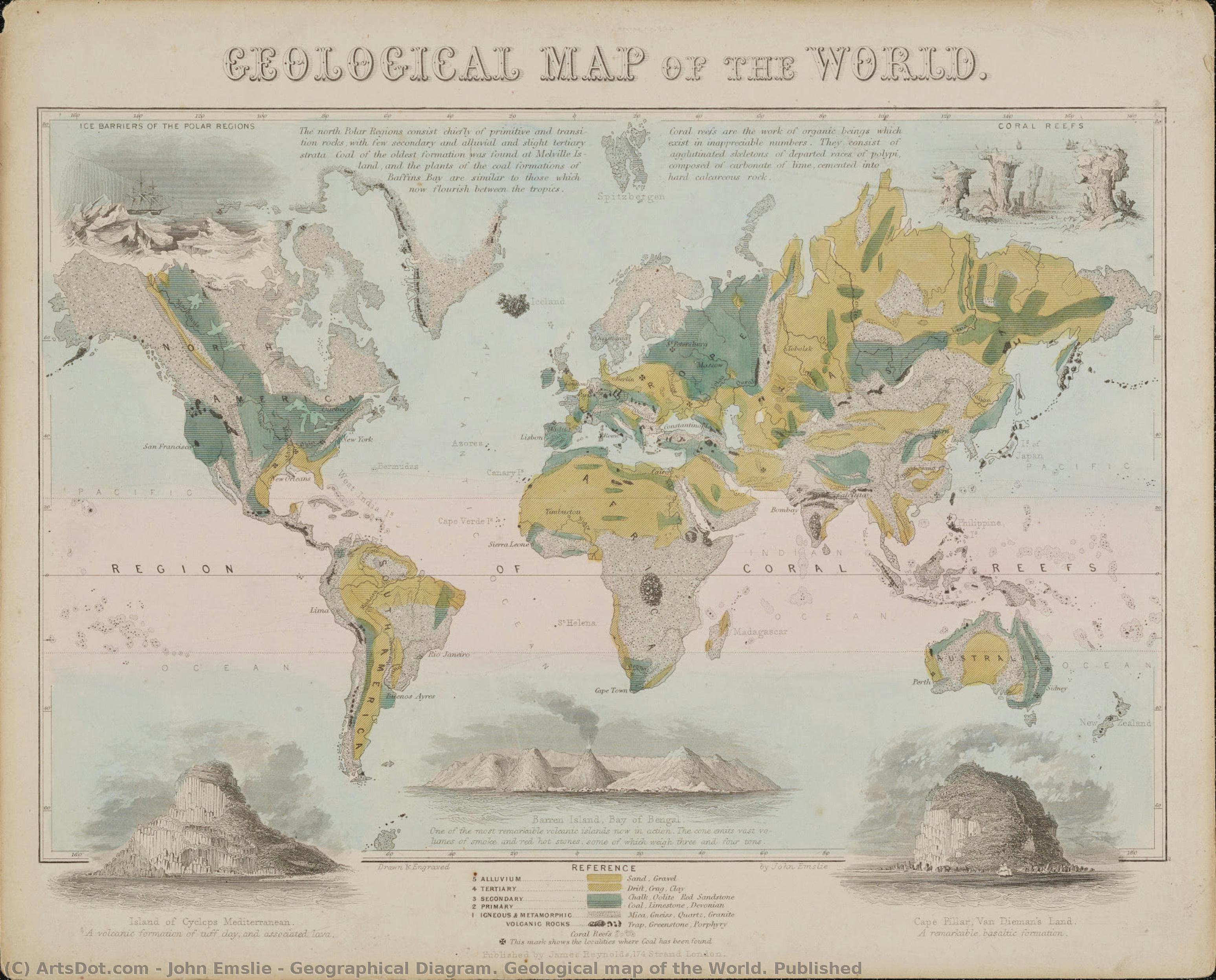
Geographical Diagram. Geological map of the World. Published


 Read More
Purchase a high-resolution, enhanced digital image, far superior to the online preview.
Each file is meticulously prepared by our in-house specialists using advanced tools and expert manual retouching. We ensure every image has exceptional clarity, precise color accuracy, and fine detail.
The final file is delivered via email within 72 hours, optimized for immediate use in professional, editorial, and print environments. This is the same quality trusted by top-tier design studios, publishers, and galleries.
Digital Image
Download a high-resolution file for personal display, printing, and creative projects. ( Buy Print Buy Hand Made Painting)
Included in Every Digital Image Order
Expert Digital Delivery, Guaranteed
When you choose ArtsDot.com, you're not just getting an image - you're receiving a professionally enhanced digital artwork, crafted with precision and backed by a satisfaction guarantee. Here's everything that comes with your order, automatically:

Fast Email Delivery
Your high-resolution digital image file will be emailed to you within 72 hours of ordering - ready for immediate use.

AI-Enhanced Digital File
Your artwork is professionally optimized using advanced AI tools and manual editing, ensuring maximum detail, clarity, and color accuracy.

Free Lifetime Re-Delivery
Accidentally deleted or lost your file? No worries - we'll resend it to you anytime, free of charge.

No Import Fees - Ever
Enjoy your artwork instantly with zero customs, duties, or delivery fees - digital downloads are always tax-free.

Color Accuracy Guarantee
We ensure your digital image reflects the original colors as closely as possible using professional tools and color management.

60-Day Satisfaction Guarantee
If you're not satisfied with your digital image, we'll revise it or refund 100% within 60 days - no questions asked.

100% Money-Back Guarantee
Not satisfied? Get a full refund within 60 days of receiving your digital file - no questions asked.

Bulk Order Discounts
Buy 3 images, save 10% - Buy 5, save 15% - Buy 10+, save 20%. Great for creative projects, galleries, and agencies.
Collectible Description
A Cartographer's Vision of a World Transformed
To gaze upon this 1850 depiction, the Geological Map of the World by John Emslie, is not merely to observe geography; it is to step directly into the intellectual fervor of the Victorian age. This painting transcends the function of a mere atlas illustration, becoming instead a profound artifact of scientific curiosity and artistic mastery. The meticulous rendering of continents and countries speaks volumes about the era's burgeoning understanding of global interconnectedness, yet the hand that painted it imbues the cold precision of science with a palpable sense of wonder.
The Artistry of Scientific Representation
John Emslie’s technique here is a masterful marriage of scientific illustration and fine art. While the subject matter—the delineation of geological strata and political boundaries—demands accuracy, the execution breathes life into the parchment. One can almost feel the weight of the drafting instruments and the careful application of pigment that brought this vision to life. The inclusion of the compass rose in the lower corner is not just a navigational aid; it serves as a symbolic anchor, orienting both the viewer and the observer within the grand narrative of human discovery. It invites contemplation on how much we know, and how much remains undiscovered.
Historical Echoes: Mid-Nineteenth Century Exploration
Painted in 1850, this map captures a world suspended between established knowledge and radical new theories. The Victorian era was a time of unprecedented exploration, industrial expansion, and scientific breakthrough. This piece reflects that tension—the desire to categorize, measure, and master the planet, all while acknowledging the vast, untamed mystery that lay beyond the known borders. For the collector or designer, owning such a reproduction is acquiring a tangible link to this pivotal moment in human intellectual history.
Symbolism and Emotional Resonance
Beyond its cartographic data, the map carries deep symbolic weight. It represents humanity's enduring impulse to chart its own existence—to find patterns, to draw lines where chaos might otherwise reign. The rich coloration used by Emslie elevates the diagram from a dry academic study to an object of aesthetic contemplation. It evokes a sense of both grand scale and intimate detail; the vastness of the oceans contrasted with the careful labeling of individual nations creates a compelling emotional dialogue between the infinite and the defined.
Bringing Global Grandeur Home
For interior design, this artwork offers unparalleled depth. Imagine it displayed where natural light can illuminate its complex details, serving as a magnificent focal point in a library, study, or grand hall. A high-quality reproduction allows one to incorporate the grandeur of historical scientific art into a modern setting, lending an air of cultivated erudition and timeless adventure to any space.
Related Artworks





Artist Biography
The Intersection of Cartography and Soul: The Life of John Philipps Emslie
In the heart of Victorian London, a period defined by both rigorous scientific advancement and a deep-seated fascination with the mystical, John Philipps Emslie emerged as a singular voice. Born in 1839 to an engraver, Emslie was destined to inherit a legacy of precision. His early years were shaped by the meticulous discipline of his father’s craft, yet his spirit sought something more expansive than mere reproduction. Through his studies under the legendary Dante Gabriel Rossetti at The Working Men's and Artisans' College, Emslie breathed life into the rigid lines of technical drawing, infusing them with the romanticism and expressive color palettes characteristic of the Pre-Raphaelite influence. This unique duality—the ability to marry the exacting eye of a cartographer with the emotive heart of a storyteller—would become the defining hallmark of his illustrious career.
Emslie’s artistic evolution was deeply intertwined with the intellectual currents of his era. As a prominent member of The Folklore Society, serving on its council from 1875, he viewed the landscape not merely as a collection of geographical coordinates, but as a living tapestry woven with oral traditions and ancient myths. His expeditions across the English countryside were more than mere topographical surveys; they were pilgrimages into the cultural memory of the nation. When he sat to document a mountain range or a rural valley, he was capturing the very breath of the land, ensuring that the scientific accuracy of his architectural studies remained inseparable from the atmospheric mystery of the folklore he so dearly loved.
A Legacy of Precision and Atmosphere
The mastery of Emslie’s technique lies in his profound command over perspective and shading, tools he used to bridge the gap between the seen and the felt. His celebrated topographical drawings are renowned for their remarkable accuracy, yet they possess a haunting quality that transcends mere documentation. In his depictions of mountainous regions, one can sense the weight of the stone and the shifting light of the clouds, rendered with a level of detail that speaks to his training in engraving. He possessed a rare ability to utilize geographical diagrams and architectural studies to create works that were both educational and deeply evocative, serving as a vital window into the Victorian intersection of science and art.
Throughout his life and work, Emslie achieved several milestones that solidified his place in British art history:
- The Synthesis of Disciplines: He successfully merged the technical rigors of cartography with the expressive freedom of Romanticism.
- Cultural Preservation: Through his involvement with The Folklore Society, he utilized his art to document and preserve the vanishing oral histories of rural England.
- Mastery of Medium: His ability to transition from the fine, precise lines of engraving to the lush, atmospheric textures of landscape painting set him apart from his contemporaries.
Today, the works of John Philipps Emslie stand as a testament to a time when the world was being mapped with both compass and imagination. His legacy remains an essential study for anyone seeking to understand how the Victorian era reconciled its thirst for empirical truth with its enduring reverence for the unknown. In every line he drew and every landscape he captured, Emslie reminded us that to truly map a place, one must also understand its soul.
john emslie
1848 - 1918 , United Kingdom
Quick Facts
- Artistic Movement Or Style: Topographical Art
- Artists Or Movements Influenced By This Artist: ['Victorian Art']
- Artists Who Influenced This Artist: ['Dante Gabriel Rossetti']
- Date Of Birth: 1839
- Date Of Death: 1913
- Full Name: John Philipps Emslie
- Nationality: British
- Notable Artworks: ['Mountain Height engraving']
- Place Of Birth: London, United Kingdom

