 Preview
 Send
Send Share
Share
 Details

 Download
 Similars
 X-Ray
X-Ray Diaporama
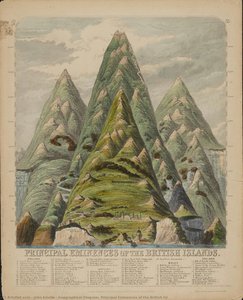
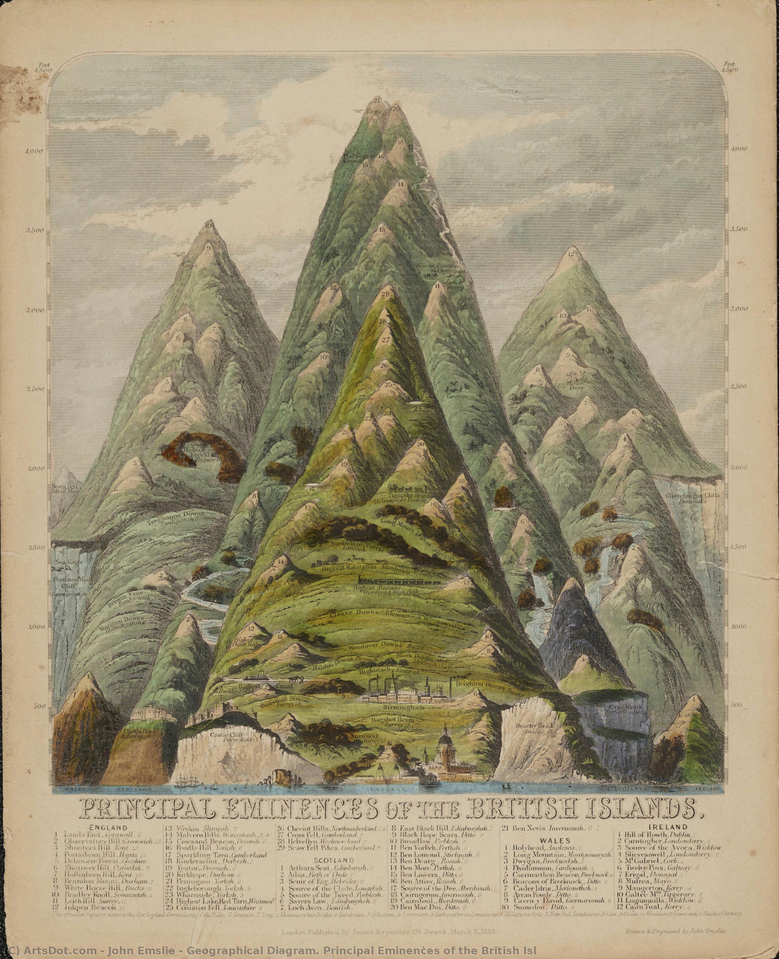
Geographical Diagram. Principal Eminences of the British Isl


 Read More
Hand Made Oil Reproduction
Hand-painted oil on canvas in your size and frame, made to order by our artists. ( Buy Print Buy Image)




P118B $10

P118H $10

P118W $10

P438Z $10

P508JH $12

P508YH $12

P805H $10

P805Z $10

P919BZ $10

P919G $10

P919XJ $10

P959ZH $10

P968JZ $12

W106C $8

W218G $10

W218JH $8

W218Y $10

W307PJ $10

W316G $10

W316PJ $8

W316Y $10

W398PJ $8

W4111J $10

W500HY $15

W500JH $15

W692G $12

W849H $8

W940BG $15

W953PJ $8




Pick from our preset sizes that match the artwork's original proportions.

You may enter your own dimensions to fit a specific frame or space. If your selected size does not match the original image's proportions, we will either crop the artwork or extend the painting with additional hand-painted elements. A digital mockup will be sent for your approval before production begins.
Please note that the on-screen preview does not reflect the actual cropping or extension. Only the mockup will accurately show the final composition.
While custom sizes are available, we recommend selecting a dimension from the predefined list to preserve the original proportions.
After order, ArtsDot.com team will email client for instructions and provide a mockup preview
Worldwide Delivery () in 3/4 weeks instead of standard 5 weeks. (17 August). No compromise on quality.

Free Worldwide Express Shipping

High-Quality Linen Canvas

Full Shipping Insurance

Customs Tax Refund Guarantee

True Color Matching Guarantee

60-Day Return Policy (Defects Only)

100% Money-Back Guarantee

Bulk Discount Offer
 Glass option is only available in size under 110 CM

Geographical Diagram. Principal Eminences of the British Isl
Reproduction Medium
Reproduction Size
-


Total Price
$ 263
Artwork Description
A Cartographic Masterpiece: The Majesty of the British Isles
In the delicate intersection of scientific precision and Romantic artistry lies John Emslie’s 1852 engraving, Geographical Diagram. Principal Eminences of the British Isles. This captivating work serves as more than a mere topographical record; it is a visual tribute to the soaring peaks that define the rugged soul of the British landscape. Through meticulous lines and thoughtful composition, Emsult captures the essence of giants such as Ben Nevis, Snowdon, and Scaw Fell Pike, presenting them not just as geological coordinates, but as monumental sentinels of nature. The piece invites the viewer to ascend through the clouds, tracing the jagged silhouettes of stone and rock that have stood the test of time, offering a profound sense of scale and grandeur that resonates with anyone who has ever felt humbled by the mountains.
The technique employed in this work reflects the pinnacle of Victorian engraving mastery. Every stroke of Emslie’s hand contributes to a textured reality, where the verdant greens of the mountain summits contrast beautifully against the stark, enduring strength of the rocky faces. The interplay of light and shadow creates a rhythmic movement across the canvas, simulating the way mist clings to high altitudes and how sunlight breaks through a shifting sky. This mastery of depth and atmosphere transforms a flat diagram into a breathing, three-dimensional experience, making it an exquisite specimen of 19th-century printmaking that bridges the gap between the analytical mind of a cartographer and the emotive heart of a fine artist.
Timeless Elegance for the Modern Collector
For the discerning collector or interior designer, this reproduction offers a unique opportunity to introduce a sense of historical depth and intellectual curiosity into a living space. The artwork’s palette—dominated by earthy tones, deep greens, and ethereal sky hues—complements a wide array of sophisticated decor styles, from the moody textures of a traditional library to the clean, minimalist lines of a contemporary gallery-style room. It acts as a conversational centerpiece, sparking discussions about geography, history, and the enduring allure of the natural world.
Beyond its aesthetic appeal, the piece carries an emotional weight that provides a grounding presence in any environment. There is a quiet, contemplative strength found in these depicted eminences, offering a window into a bygone era when exploration and discovery were woven into the very fabric of art. To hang this work is to invite the timeless spirit of the British Isles into one's home, surrounding oneself with the enduring beauty of the earth's most magnificent heights. It is an investment in heritage, a celebration of topographical splendor, and a soulful addition to any curated collection.
Related Artworks
Artist Biography
The Intersection of Cartography and Soul: The Life of John Philipps Emslie
In the heart of Victorian London, a period defined by both rigorous scientific advancement and a deep-seated fascination with the mystical, John Philipps Emslie emerged as a singular voice. Born in 1839 to an engraver, Emslie was destined to inherit a legacy of precision. His early years were shaped by the meticulous discipline of his father’s craft, yet his spirit sought something more expansive than mere reproduction. Through his studies under the legendary Dante Gabriel Rossetti at The Working Men's and Artisans' College, Emslie breathed life into the rigid lines of technical drawing, infusing them with the romanticism and expressive color palettes characteristic of the Pre-Raphaelite influence. This unique duality—the ability to marry the exacting eye of a cartographer with the emotive heart of a storyteller—would become the defining hallmark of his illustrious career.
Emslie’s artistic evolution was deeply intertwined with the intellectual currents of his era. As a prominent member of The Folklore Society, serving on its council from 1875, he viewed the landscape not merely as a collection of geographical coordinates, but as a living tapestry woven with oral traditions and ancient myths. His expeditions across the English countryside were more than mere topographical surveys; they were pilgrimages into the cultural memory of the nation. When he sat to document a mountain range or a rural valley, he was capturing the very breath of the land, ensuring that the scientific accuracy of his architectural studies remained inseparable from the atmospheric mystery of the folklore he so dearly loved.
A Legacy of Precision and Atmosphere
The mastery of Emslie’s technique lies in his profound command over perspective and shading, tools he used to bridge the gap between the seen and the felt. His celebrated topographical drawings are renowned for their remarkable accuracy, yet they possess a haunting quality that transcends mere documentation. In his depictions of mountainous regions, one can sense the weight of the stone and the shifting light of the clouds, rendered with a level of detail that speaks to his training in engraving. He possessed a rare ability to utilize geographical diagrams and architectural studies to create works that were both educational and deeply evocative, serving as a vital window into the Victorian intersection of science and art.
Throughout his life and work, Emslie achieved several milestones that solidified his place in British art history:
- The Synthesis of Disciplines: He successfully merged the technical rigors of cartography with the expressive freedom of Romanticism.
- Cultural Preservation: Through his involvement with The Folklore Society, he utilized his art to document and preserve the vanishing oral histories of rural England.
- Mastery of Medium: His ability to transition from the fine, precise lines of engraving to the lush, atmospheric textures of landscape painting set him apart from his contemporaries.
Today, the works of John Philipps Emslie stand as a testament to a time when the world was being mapped with both compass and imagination. His legacy remains an essential study for anyone seeking to understand how the Victorian era reconciled its thirst for empirical truth with its enduring reverence for the unknown. In every line he drew and every landscape he captured, Emslie reminded us that to truly map a place, one must also understand its soul.
john emslie
1848 - 1918 , United Kingdom
Quick Facts
- Artistic Movement Or Style: Topographical Art
- Artists Or Movements Influenced By This Artist: ['Victorian Art']
- Artists Who Influenced This Artist: ['Dante Gabriel Rossetti']
- Date Of Birth: 1839
- Date Of Death: 1913
- Full Name: John Philipps Emslie
- Nationality: British
- Notable Artworks: ['Mountain Height engraving']
- Place Of Birth: London, United Kingdom
Related Articles
Verdant Visions: Exploring the Symbolism & Aesthetic Impact of Green in Art History
Explore the rich history & symbolism of green in art! Discover iconic paintings, techniques, and how to bring verdant harmony into your home with ArtsDot's expert guide.

Emerald Visions: Top 10 Paintings Dominated by Cadmium Green |
Explore 10 iconic paintings where cadmium green reigns supreme! From Monet to Van Gogh, discover the stories behind these masterpieces & the power of color. Find museum-quality art reproductions and elevate your home decor on .
Dark Olive Green Masterpieces: 10 Iconic Paintings & Decor Ideas
Explore 10 iconic paintings where dark olive green reigns supreme! From Van Gogh to Rembrandt, discover art history's most captivating masterpieces & the stories behind them. Find museum-quality reproductions and curated decor ideas at .
Chrome Green Masterpieces: 10 Famous Paintings & Their Alluring Hues |
Explore 10 famous paintings where 'Chrome Green' reigns supreme! Discover Monet, Manet & Van Gogh’s masterpieces. Learn the stories behind these iconic artworks and find museum-quality art reproductions for your home at .

Seafoam & Masterpieces: 10 Paintings Dominated by Medium Sea Green | ArtsDot
Dive into serenity with 10 famous paintings bathed in calming medium sea green. Explore Impressionist masterpieces by Monet, Degas & Renoir. Find museum-quality art reproductions and elevate your home decor at ArtsDot.com.