

 Preview
 Send
Send Share
Share
 Details

 Download
 Similars
 X-Ray
X-Ray Diaporama
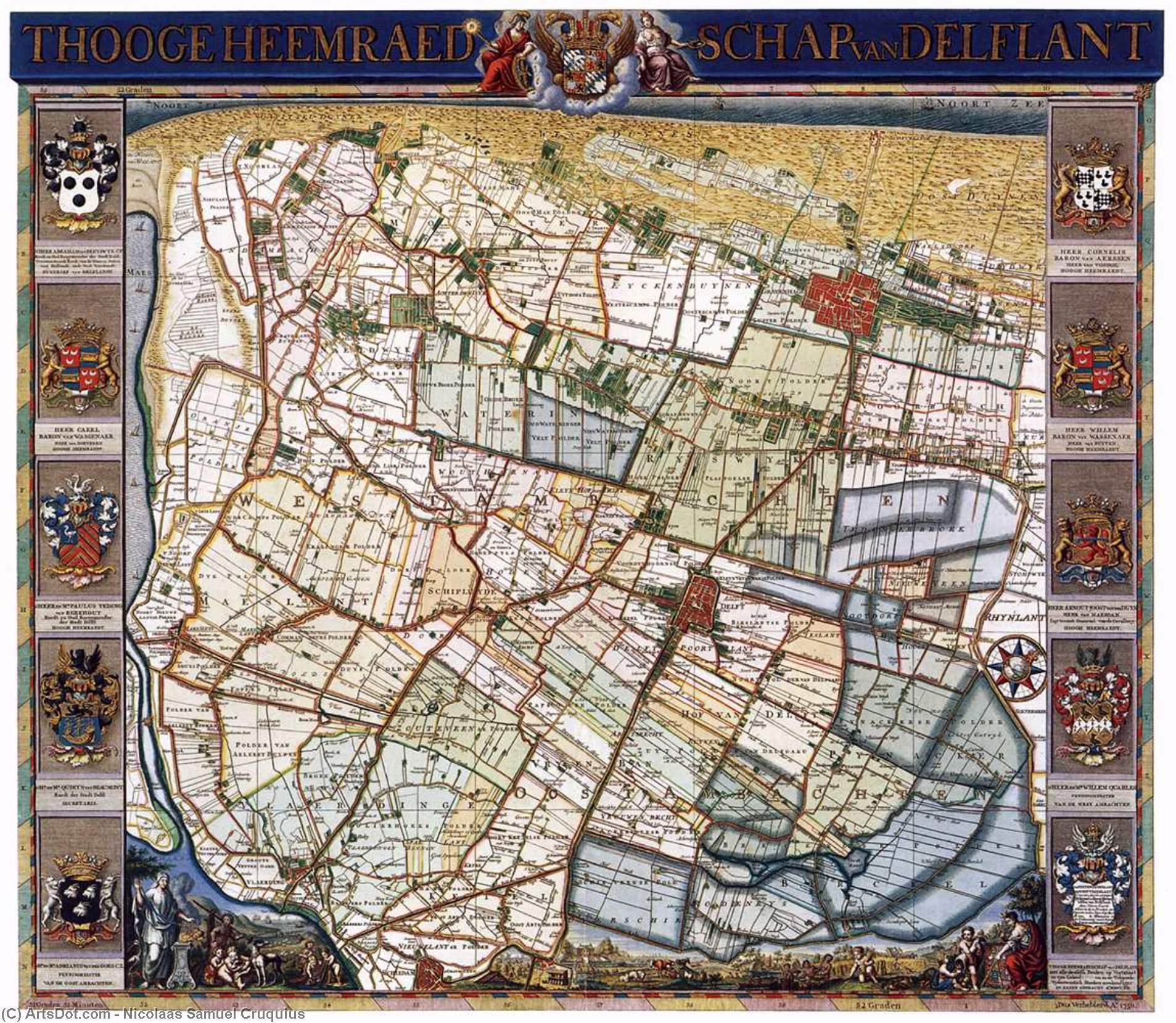
Map of Delfland
 Print
Print- WallArt
 1750
1750- Early Modern
 543.0 x 657.0 cm
 Rijksmuseum
 Read More
Purchase a high-resolution, enhanced digital image, far superior to the online preview.
Each file is meticulously prepared by our in-house specialists using advanced tools and expert manual retouching. We ensure every image has exceptional clarity, precise color accuracy, and fine detail.
The final file is delivered via email within 72 hours, optimized for immediate use in professional, editorial, and print environments. This is the same quality trusted by top-tier design studios, publishers, and galleries.
Digital Image
Download a high-resolution file for personal display, printing, and creative projects. ( Buy Print Buy Hand Made Painting)
Included in Every Digital Image Order
Expert Digital Delivery, Guaranteed
When you choose ArtsDot.com, you're not just getting an image - you're receiving a professionally enhanced digital artwork, crafted with precision and backed by a satisfaction guarantee. Here's everything that comes with your order, automatically:

Fast Email Delivery
Your high-resolution digital image file will be emailed to you within 72 hours of ordering - ready for immediate use.

AI-Enhanced Digital File
Your artwork is professionally optimized using advanced AI tools and manual editing, ensuring maximum detail, clarity, and color accuracy.

Free Lifetime Re-Delivery
Accidentally deleted or lost your file? No worries - we'll resend it to you anytime, free of charge.

No Import Fees - Ever
Enjoy your artwork instantly with zero customs, duties, or delivery fees - digital downloads are always tax-free.

Color Accuracy Guarantee
We ensure your digital image reflects the original colors as closely as possible using professional tools and color management.

60-Day Satisfaction Guarantee
If you're not satisfied with your digital image, we'll revise it or refund 100% within 60 days - no questions asked.

100% Money-Back Guarantee
Not satisfied? Get a full refund within 60 days of receiving your digital file - no questions asked.

Bulk Order Discounts
Buy 3 images, save 10% - Buy 5, save 15% - Buy 10+, save 20%. Great for creative projects, galleries, and agencies.
Collectible Description
A Cartographic Masterpiece: The World in Miniature
In the grand tradition of the Dutch Golden Age, where scientific precision met unparalleled artistic elegance, the Map of Delfland stands as a breathtaking testament to human curiosity and the mastery of Nicolaas Samuel Cruquius. This expansive work, dating from approximately 1750, is far more than a mere navigational tool; it is a meticulously crafted tapestry of geography and artistry. At first glance, the viewer is swept into a detailed topographical landscape where the verdant greens of fertile fields meet the earthy browns of ancient woodlands. The map captures the essence of the northern part of Zuid-Holland, presenting a world that feels both intimately familiar and grandly epic. For the discerning collector or interior designer, this piece offers a window into an era when every line drawn on parchment was an act of discovery.
The technique employed by Cruquius reflects his dual identity as both a hydraulic engineer and a fine artist. There is a rhythmic precision to the way the waterways, canals, and coastlines are rendered, suggesting a deep understanding of the very land he sought to document. The use of color is subtle yet purposeful, with soft washes of pigment creating depth and texture across the terrain. Small, vibrant red accents punctuate the landscape, marking the vital pulse of towns and cities, acting as beacons of civilization amidst the sprawling natural expanse. This delicate balance between technical accuracy and aesthetic grace ensures that the map functions perfectly as a focal point in any sophisticated interior, commanding attention through its intricate detail and harmonious palette.
Symbolism and the Spirit of the Dutch Golden Age
Beyond its geographical utility, the Map of Delfland is rich with symbolic layers that speak to the political and social fabric of the 18th century. The periphery of the central map is adorned with a magnificent array of coats of arms, each a silent herald of the families, regions, and institutions that shaped the Dutch identity. These heraldic elements transform the map into a genealogical record of power and prestige. Furthermore, the inclusion of coastal profiles and specialized illustrations—such as detailed harbor plans—serves to celebrate the maritime prowess and commercial vitality that defined the Netherlands. To gaze upon this work is to witness the pride of a nation that had mastered both the sea and the soil.
For those looking to integrate such a piece into a curated space, the emotional impact is profound. It evokes a sense of nostalgia for an age of exploration and the quiet dignity of scholarly pursuit. The presence of this reproduction in a study, library, or grand living room provides an atmosphere of intellectual depth and timeless sophistication. It invites conversation, prompting viewers to trace the winding paths of history and contemplate the enduring legacy of the Dutch masters. Owning a piece of such historical significance is not merely about decoration; it is about preserving a fragment of the human spirit's eternal quest to map the unknown.
Related Artworks



Artist Biography
The Intersection of Science and Art: The Legacy of Nicolaas Samuel Cruquius
In the grand tapestry of the Dutch Golden Age, few figures embody the era's unique marriage of empirical inquiry and aesthetic grace as profoundly as Nicolaas Samuel Cruquius. Born in the windswept serenity of West-Vlieland in 1678, Cruquius—often known by his original name, Nicolaas Kruik—was a man whose life was defined by the dual pursuit of mapping the physical world and capturing its ephemeral beauty. His existence was not merely that of a painter, but of a polymath: a land surveyor, cartographer, astronomer, and hydraulic engineer. This rare combination of disciplines allowed him to view the landscape through a lens that was simultaneously scientific and deeply poetic, creating works that served as both precise records of geography and soulful meditations on nature.
Cruquius’s intellectual journey was shaped by the rigorous academic atmosphere of his time. His studies in mathematics and surveying provided the technical foundation for his later cartographic triumphs, yet it was his immersion in the scientific discourse of Leiden University that truly expanded his horizons. Influenced by the pioneering medical scholar Herman Boerhaave, Cruquius embraced an empirical worldview, a mindset that would later manifest in his meticulous attention to topographical detail. This dedication to accuracy did not come at the expense of artistry; rather, it informed a style where every contour line and waterway was rendered with a rhythmic precision that suggested a deep, intimate understanding of the earth's very anatomy.
A Cartographic Vision: Precision Meets Elegance
As his career flourished, Cruquius established himself as a preeminent figure within Delft’s Royal Guild of St. Luke. His reputation as a surveyor led to prestigious commissions across Holland and Flanders, where he transformed the utilitarian task of mapping into a high art form. One of his most breathtaking achievements, the Map of Delfland, serves as a quintessential example of his mastery. In this work, the viewer is not merely presented with a navigational guide but is instead invited into a miniature world where verdant fields and earthy woodlands coalesce in a harmonious display of color and texture.
What set Cruquius apart from his contemporaries was his ability to integrate groundbreaking scientific techniques into his visual compositions. He was an early adopter of isobaths—contour lines representing water depth—which allowed him to visualize the unseen underwater topography with unprecedented clarity. This innovation reflected his lifelong preoccupation with hydraulic engineering and the management of the Dutch landscape. His maps were often adorned with magnificent coats of arms and subtle, vibrant accents that acted as beacons of civilization amidst the sprawling natural expanse, turning a technical document into a celebratory piece of heraldic art.
The Soul of the Landscape: Genre and Legacy
Beyond the rigid lines of his maps, Cruquius found profound expression in his paintings of serene landscapes and genre scenes. His artistic output often captured the quiet dignity of the elite of Antwerp, portraying scenes that felt both intimately familiar and grandly epic. These works were characterized by a soft, purposeful use of pigment, creating depths and textures that breathed life into the canvas. Through his brush, the landscape became more than just terrain; it became a stage for the social and political fabric of the 18th century.
The historical significance of Nicolaas Samuel Cruquius extends far beyond the borders of his canvases. His visionary proposals to pump the Haarlemmermeer dry left an indelible mark on the Dutch landscape, a legacy so enduring that a village and a museum now bear his name. He remains a symbol of an era when the pursuit of knowledge and the appreciation of beauty were seen as two sides of the same coin. To study the work of Cruquius is to witness the spirit of the Dutch Golden Age—a period defined by a relentless curiosity about the natural world and an unwavering commitment to documenting its splendor with both scientific truth and artistic soul.
nicolaas samuel cruquius
1678 - 1754 , Netherlands
Quick Facts
- Artistic Movement Or Style: Dutch Golden Age Art
- Artists Or Movements Influenced By This Artist: ['Romanticism']
- Artists Who Influenced This Artist: ['Herman Boerhaave']
- Date Of Birth: December 2, 1678
- Full Name: Nicolaas Samuel Cruquius
- Nationality: Dutch
- Notable Artworks:
- Gardens on the Nieuwe Laan
- Map of Delfland
- Place Of Birth: Vlieland, Netherlands

